BULLFROG RAMP CONDITIONS

Status
Not open for further replies.
Dave, did you happen to graph 1/4 mile off the Stanton haystacks? That area is going to be a prop buster again this year. Sq
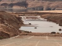
That area around Stanton is really low. We drove the boat up in there and did not see anywhere to unload. I am not familiar at all with Stanton so I don’t even know where you would usually dump a boat but to me it is not going to happen. Someone that is familiar with the area needs to check it out but it does not look good to me. The area out in front towards Halls is less than 10 feet until you get to the bullfrog channel, you are correct there are going to be some props ruined there in the near future. It looks like you can cut across that bay but my maps showed it less than 10 feet for a long ways out there.
 
Yes, that low water area extends 1/4 mile or more from the haystacks, all the way to the Green 95 buoy close to the Hall’s houseboat field at the river bottom trench . DON’T cut the corner going North from Bullfrog bay. Sq

Bullfrog.jpg
Here's a picture of that shelf, courtesy of Pegasus. Definitely want to stay in the channel. Here is a link to his previous post, it has some great pics at roughly this level. Thanks again Pegasus. Flights Over LP-March 15 and 17 2019, water level 3570.8, and March 31 2019 water level 3569.39
 
Well, I guess that settles it. North end of the Lake is nothing but trouble, not worth it. I hope, for their sake (obviously), as many people AS POSSIBLE head down to the South end and enjoy smooth sailing and care free vacations. Maybe some Wordlings could bite the bullet and stick around to help hold the fort down on the north end, though.
No No No. The South is to crowded
 
They are out of the water. What they should be doing is getting equipment and clean up the shore line around the ramps and pick up the rocks.
 
Last edited:
The ferry ramp is in the middle of the Halls boat ramp. There is room to launch one boat at a time and if there are cars waiting for the ferry. You will more than likely have to back down the entire ramp to the water. I am heading back down on the 15th and will take pictures.
 
These are a few maps I found on a HB. Keep in mind that this is a reverse topo map and the "zero" mark is full pool. The larger the number, the deeper it is. So, look for the 100' on the topo and that would be close to today's elevation.

Couldn't find the one for the Bullfrog ramp it's self but didn't look too closely either. This just gives an idea as to what it looks like under the water.
LP TopoDSCN0638_611.JPGLP TopoDSCN0637_610.JPG
 
Anyone have any new pictures of the Bullfrog Ramp? Square
I didn't think about taking a picture but we walked down to look around Monday afternoon. Watched a 24 ft. Bayliner aft cabin load they had to back in way to far me don't like water around my doors. We were told by a ranger he'd use the other ramp so that's what we did there was only 4 or 5 boats there the wind blew everybody off at same time seemed like, went pretty fast for only loading 2 at time. Hopefully we get some run off can't imagine when it gets a little busy. Sorry no picture.
 
Status
Not open for further replies.
Back
Top