(Unofficial) Recent Ramp Conditions / Experiences / Photos 2023

Status
Not open for further replies.
We have launched there many times in the past at these water levels the old road base gravel is good and drop off on right side is a good grade for launching. We even had houseboat retrieved there at about this level. Usually a lot less busy. There are a few small islands so you need to be cautious and run straight out to the Channel before heading out. Even Those should be covered enough in a day or two
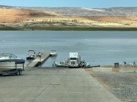
All the heavy equipment and vehicles have been removed from bottom of ramp,
not sure if when they will open it. The current lake level it is usable at your own risk of course.
It is still barricaded off and marked as closed as of Noon today Friday the 19th .
 
NPS just released new ramp information -

 
There was also the Legacy Wahweap Auxiliary Ramp (right next to the marina and fuel docks) that was made available while the new Legacy Stateline Auxiliary (Gustaveson) Ramp was renovated. I'm wondering if that might be the elevation they've provided?

Doing a little research through old NPS news releases, it appears that Wahweap Main Ramp was useable (on boilerplate) to 3555 in June 2021.

So, the LPWDB shows Wahweap safely usable at 3546. Is that the Wahweap Auxillary?
This notice for Wahweap (main) says plates extended to 3555, an additional 5 to 7 feet. So concrete is actually usable about 3562 (same as Stateline). Chemosabe concluded this yesterday morning in this thread #71. Pics in #61 looks like another 15 feet. Color me confused.
Possibly, both numbers (3546 and 3555) came from NPS News Releases. I'm just speculating about how they might have come up with the first one (which is obviously inaccurate for Wahweap Main Ramp). I would plan on 3555 as a bare minimum especially since they have no plans to make further public use of the Wahweap Auxiliary Ramp.
 
Couple questions
Bullfrog main ramp is listed as nn usable at 3576 which is about 32 feet above current lake level.
Looking at it is appears it would be usable at much lower level was the elevation adjusted for the most recent extension work done?
Picture from Sat morning it looks like it would be usable with 15-20 more elevation (attached) have to zoom to see it .
Also why not open spur section ofv of the main ramp even if got only commercial rafts to use. It’s perfect for that application and would keep congestion down at executive ramp
When river trips have to load gear and rafts, which is what we encountered this morning. Only one small lane usable for launching retrieving boats due to river rafts unloading and packing up
See picture from Sat morning!
Makes no sense to
Not let them use the spur would be perfect for that especially.
 

Attachments

  • 6C6A5EF5-2CFF-4416-8794-C07C37A07D45.jpeg
    6C6A5EF5-2CFF-4416-8794-C07C37A07D45.jpeg
    520 KB · Views: 160
  • 681FD89C-1716-49B6-9ADF-25177A03F37A.jpeg
    681FD89C-1716-49B6-9ADF-25177A03F37A.jpeg
    313.7 KB · Views: 159
Couple questions
Bullfrog main ramp is listed as nn usable at 3576 which is about 32 feet above current lake level.
Looking at it is appears it would be usable at much lower level was the elevation adjusted for the most recent extension work done?
Picture from Sat morning it looks like it would be usable with 15-20 more elevation (attached) have to zoom to see it .
Also why not open spur section ofv of the main ramp even if got only commercial rafts to use. It’s perfect for that application and would keep congestion down at executive ramp
When river trips have to load gear and rafts, which is what we encountered this morning. Only one small lane usable for launching retrieving boats due to river rafts unloading and packing up
See picture from Sat morning!
Makes no sense to
Not let them use the spur would be perfect for that especially.

My guess is that the numbers haven't officially changed since the coffer dam was removed. Definitely usable at lower levels now.

My interpretation of recent NPS communications: the plan is to move rafters to the spur and main ramp area asap. Just waiting on the last of the DR debris.

Good pics!
 
My guess is that the numbers haven't officially changed since the coffer dam was removed. Definitely usable at lower levels now.

My interpretation of recent NPS communications: the plan is to move rafters to the spur and main ramp area asap. Just waiting on the last of the DR debris.

Good pics!
It was all removed from what we saw from above and in the water and all heavy equipment gone
By Saturday morning?
 
Status
Not open for further replies.
Back
Top