
You are using an out of date browser. It may not display this or other websites correctly.
You should upgrade or use an alternative browser.
You should upgrade or use an alternative browser.
(Unofficial) Recent Ramp Conditions / Experiences / Photos 2023
- Thread starter BartsPlace
- Start date
- Status
- Not open for further replies.


great effort by you, thank you.May 17, 2023
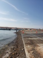
Stateline Main Ramp with (we assume) the inop webcam in foreground.
View attachment 22595
Stateline Aux fully submerged concrete and lots of debris. Second ramp is back on the right looking down toward water
View attachment 22596
View attachment 22597
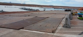
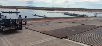
Wahweap Main with worker prepping boiler plates. Lake should be touching the bottom of the new fill (dark area) in another 7-10 days.
View attachment 22598
View attachment 22599
How bout Halls Crossing????does anyone have a main ramp picture update for bullfrog? thanks in advance.
nzaugg
Keeper of San Juan Secrets
It's still 15 feet from the water...How bout Halls Crossing????
Yep just like the PICS!!!!It's still 15 feet from the water...

nzaugg
Keeper of San Juan Secrets
OK. Here is a pic. Just imagine it with 20 feet of additional water, none of which will show up in the foreground that you are seeing since it is a drop-off to the lake.Yep just like the PICS!!!!
")

Mildog
Well-Known Member
Bullfrog Main Ramp and spur RAMP IS CLOSED FOR CONSTRUCTION
More like deconstruction
There is still some debris and heavy equipment at the bottom and sign saying closed. It is at usable elevation for spur section, but they are not finished with the work in removing the remnants of the Dangling Rope marina, docks etc
Reports were posted earlier about a construction accident resulting in a fatality (very sad) which may delay finishing the project and allowing use of the spur.
Here are pics of ramp from
The top as of 7 PM TODAY.
Minimum usable on the water database is saying 3544 @ Wahweap? Doesn't add up. Looks like we need 15 more.
Maverick5207
Escalante-Class Member
john schebler
Active Member
Not really a ramp, but has anyone heard when they are going to move the pedestrian ramp to the bullfrog marina? I was in the slip when they did the move from the “cut” rock to the 1st row of slips for the access. They use the piece of dock. So I was on an island for a day waiting for it to get moved.

Paul_G
Well-Known Member
I went through Sentinal Hub back to 3545 when the ramp should have been open and it's far from the water in the picture. Went back until it looked like the water was touching it and boats were using it and that level was 3560. Sounds like we have a ways to go and the NPS needs to update that usable elevation.Minimum usable on the water database is saying 3544 @ Wahweap? Doesn't add up. Looks like we need 15 more.
nzaugg
Keeper of San Juan Secrets
As I recall, they were using boiler plate for a while and then switched over to the Gustaveson Ramp once it was ready. There was a period of a week or so where there were no launch options though, since there was an issue at the main ramp underwater preventing launches. I think these improvised ramps (Bullfrog Spur) and boiler plate options are probably not ideal though and shouldn't be listed as standard options.Picture from the NPS.Gov website on 7/17/21. They were assessing the ramp. Water level was 3556 on that day.
There was also the Legacy Wahweap Auxiliary Ramp (right next to the marina and fuel docks) that was made available while the new Legacy Stateline Auxiliary (Gustaveson) Ramp was renovated. I'm wondering if that might be the elevation they've provided?
Doing a little research through old NPS news releases, it appears that Wahweap Main Ramp was useable (on boilerplate) to 3555 in June 2021.

 www.nps.gov
Doing a little research through old NPS news releases, it appears that Wahweap Main Ramp was useable (on boilerplate) to 3555 in June 2021.
Lake Powell’s Wahweap Main Ramp Being Extended June 30 - Glen Canyon National Recreation Area (U.S. National Park Service)
Lake Powell’s Wahweap Main Ramp Being Extended June 30
It also appears that the cut-over from Stateline Auxiliary to Stateline Main should be fairly seamless when the time comes.

Mildog
Well-Known Member
Buddies Houseboat launch delayed so we worked on boat and took a drive to look at colorado coming in and Hite.
I’ll post some info and pics later, they had road access blocked so I walked down the HITE concrete ramp and then all the way to the river. Lots of flow and debris coming in cool to see. We Stopped at raft pull out and looked, I don’t think it’s useable at these flows it was ripping and steep banks. If we ever could see full pool, there would be 90 feet of water out from the hite ramp and deeper in river channel. Launching of gravel at bottom of ramp would be doable at 3640 or a bit less, and lower level than that you could launch further down by where marina was.
* update on Bullfrog main/spur still closed here’s a pic to compare yesterday to today, about 16 inches more water!
Someone asked about new gravel I think it the same road Base gravel as before saw a few more trucks hauling stuff up
The ramp and away. Spur looks like you could launch but sign still
Up CLOSED FOR CONSTRUCTION.
nzaugg
Keeper of San Juan Secrets
Could launch and would launch are two different questions for me in that area. The best side to launch off of is the north and if you aren't careful, you will find yourself in dirt really fast. I would caution anyone against using that area now that the Bullfrog North ramp covers an even greater range of lake levels than that spur road.Buddies Houseboat launch delayed so we worked on boat and took a drive to look at colorado coming in and Hite.
I’ll post some info and pics later, they had road access blocked so I walked down the HITE concrete ramp and then all the way to the river. Lots of flow and debris coming in cool to see. We Stopped at raft pull out and looked, I don’t think it’s useable at these flows it was ripping and steep banks. If we ever could see full pool, there would be 90 feet of water out from the hite ramp and deeper in river channel. Launching of gravel at bottom of ramp would be doable at 3640 or a bit less, and lower level than that you could launch further down by where marina was.
* update on Bullfrog main/spur still closed here’s a pic to compare yesterday to today, about 16 inches more water!
Someone asked about new gravel I think it the same road Base gravel as before saw a few more trucks hauling stuff up
The ramp and away. Spur looks like you could launch but sign still
Up CLOSED FOR CONSTRUCTION.
- Status
- Not open for further replies.