You are using an out of date browser. It may not display this or other websites correctly.
You should upgrade or use an alternative browser.
You should upgrade or use an alternative browser.
Lake Powell - Photos from the Early Years
- Thread starter JFRCalifornia
- Start date


Joe Wilson
Well-Known Member
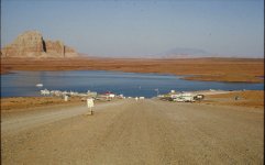
I'm gonna say its after '88. The red and silver truck with the camper shell (foreground almost center) is the new body style. And the suburbans, 1-tons and blazers kept the squarebody till '91.Agreed, there are a lot of square body Chevy trucks in that pic and nothing new. That body style ended after 1987.
I'm gonna say its after '88. The red and silver truck with the camper shell (foreground almost center) is the new body style. And the suburbans, 1-tons and blazers kept the squarebody till '91.
That does kind of look like the next gen body style. You may be correct.
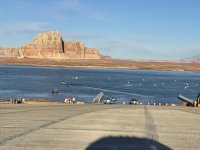
What ever happened to those rocks just offshore to the right of the restrooms in the picture? (Edit: Based on what looks like water around the restrooms I was thinking that the level was full pool, but perhaps those are the rock outcroppings on the south side of the main ramp.)I think we'll hold off on launching! Taken from Bullfrog Lodge parking lot. My guess this is from early 90s based on the vehicles in the parking lot.
91 - elevation 3632
92 - elevation 3631
93 - elevation 3647
The second pic is cleaned up by Gemini AIView attachment 35027View attachment 35028
Last edited:

JFRCalifornia
Keeper of San Juan Secrets
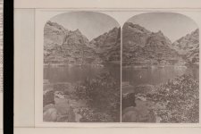
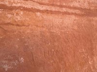
Here's a true piece of history - a stereo pair of photos of Hole in the Rock taken from across the river in July 1872, almost eight years before the Hole in the Rock pioneers made their way down the slope. The bottom part looks almost doable, better than it does today...

Trix
Keeper of San Juan Secrets
Ok, gotta ask since you almost certainly have a very educated guess. The river looks pretty robust to me. How deep?
The expedition was in November to January so lower water, even I could maybe find that depth.
Edit, I read they ferried the wagons across, so always too deep to wheel across. So now my question is kinda moot, but still curious.
The expedition was in November to January so lower water, even I could maybe find that depth.
Edit, I read they ferried the wagons across, so always too deep to wheel across. So now my question is kinda moot, but still curious.
Last edited:

It may look more doable today in this picture, but I do not think you could find a group of people willing enough or even with a work ethic to do what my Great Grand Father, Walter C Lyman, and his brother, Platte D Lyman did. After the pioneers came down the Hole-In-The-Rock and eventually reached their destination along the San Juan River, Bluff Utah now, they, Walter and Platte, turned around went back up the Hole-In-The-Rock to get a load of flour and then went back down it back to Bluff. Three trips, one up and two down. Please note that the horses the pioneers used to get wagons down the Hole-In-The-Rock had been blinded by an illness earlier in life. Horses that could see had more sense and would not steep off the cliff. I've traveled on some of this trail and was in awe, and sometimes a little scared, for what these people did.Here's a true piece of history - a stereo pair of photos of Hole in the Rock taken from across the river in July 1872, almost eight years before the Hole in the Rock pioneers made their way down the slope. The bottom part looks almost doable, better than it does today...
View attachment 35964
JFRCalifornia
Keeper of San Juan Secrets
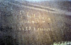
I agree--what those folks did crossing the river in the dead of winter was an amazing feat of engineering, faith, creativity and perseverance. And it was even harder once they reached the other side. It's so interesting you are related to the pioneering Lymans. I'm not related to any of those people, but I follow their story closely. Is your great grandfather the Walter Lyman who died in 1943? I'm assuming so. He would have been only 16 or 17 at the time of the journey. One thing you might find interesting (and you might know this already) is that Platte and Walter's brother Edward Leo Lyman left his mark on Register Rock that is still visible today. I'm attaching a couple of photos--one from 1962, when the signatures were very visible, and another I took of the same signatures in 2025 where water erosion has taken its toll, but you can still read "E.L. Lyman". Here's my question to you: who is "H.M. Lyman"? I've searched through the records, and the huge horde of siblings and offspring of the Lymans, but I can't find an H.M. Lyman of the age who would have crossed in 1880. Any clues?It may look more doable today in this picture, but I do not think you could find a group of people willing enough or even with a work ethic to do what my Great Grand Father, Walter C Lyman, and his brother, Platte D Lyman did. After the pioneers came down the Hole-In-The-Rock and eventually reached their destination along the San Juan River, Bluff Utah now, they, Walter and Platte, turned around went back up the Hole-In-The-Rock to get a load of flour and then went back down it back to Bluff. Three trips, one up and two down. Please note that the horses the pioneers used to get wagons down the Hole-In-The-Rock had been blinded by an illness earlier in life. Horses that could see had more sense and would not steep off the cliff. I've traveled on some of this trail and was in awe, and sometimes a little scared, for what these people did.

Jan Hertzen
Well-Known Member
Not to be critical JFR, but that looks like a lake, not a river. And look how high the river is.Here's a true piece of history - a stereo pair of photos of Hole in the Rock taken from across the river in July 1872, almost eight years before the Hole in the Rock pioneers made their way down the slope. The bottom part looks almost doable, better than it does today...
View attachment 35964
Water on the Parker Strip looks like that, though, and it's moving. . .
JFRCalifornia
Keeper of San Juan Secrets
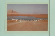
Here's what launching at Wahweap looked like in September 1964, when the lake was at 3490... could be useful information for the future...
JFRCalifornia
Keeper of San Juan Secrets
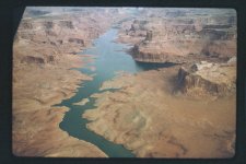
And here's one of the earliest shots of Lake Powell on the rise, taken on 5-28-63, looking up Last Chance as it begins to flood. The lake at that time was at 3335...
Trix
Keeper of San Juan Secrets
I’m confused, as usual. I thought there is a sharp drop off, a cliff, at the end of Wahweap Main right now. Did the graded ramp erode?Here's what launching at Wahweap looked like in September 1964, when the lake was at 3490... could be useful information for the future...
View attachment 35975
JFRCalifornia
Keeper of San Juan Secrets
An early NPS publication called "Meet Lake Powell", which came out in the first half of 1964, might shed some light on this. Or it might just make things muddier. I'll quote what it says about Wahweap Marina:I’m confused, as usual. I thought there is a sharp drop off, a cliff, at the end of Wahweap Main right now. Did the graded ramp erode?
*****
"The National Park Service has provided boat launching ramps to accommodate the visiting public at all stages of lake elevation. The ramps in use at the bottom of Wahweap Canyon will provde access during the formative days, are of a temporary nature, although designed to be safe and convenient. Such construction is practical since these ramps will be lost forever beneath the lake surface. They are below the minimum pool storage level of the reservoir.
When the surface of Lake Powell passes the 420-foot depth line at the dam, (it is at the 277-foot mark on February 1, 1964), its waves will be lapping at the lower edge of the permanent public launching ramp at Wahweap, and boating activities will center there. It is interesting to note that when this ramp comes into use, Lake Powell will be 170 feet deep in the middle of Wahweap Basin. The time the lake will reach this elevation is now unpredictable..."
[JFR NOTE: When the lake is 420 feet deep at the dam, that means the surface elevation is 3560. The lake didn't reach 3560 until 1969. But then it goes on to describe what will eventually become the permanent design, and writes about it as if it has already been constructed. Confusing.]
"This ramp has been designed and constructed to meet the modern demands of a heavily used marina. Its 1,100 feet of asphalt surfaced pavement will extend well into the water at normal lake elevations. A 500-foot extension at the lower end of the ramp has been constructed as an economical feature to continue launchings when the reservoir is at its very lowest permissible levels. The gravel surface of this lower prolongation is expected to be submerged except during rare periods in the life of the lake. The 200-foot width of the ramp will provide spacious rom for the maneuvering of cars and boat trailers, and additionally, will be used as a parking area for the convenience of the boating public. Its 8.5% grade should permit easy launching of a boat..."
Not sure any of this helps clear the confusion, or just causes more... I know figuring this out involves math.

Bill Sampson
Keeper of San Juan Secrets
This is a really great reference at to whale locations at lower water levels.And here's one of the earliest shots of Lake Powell on the rise, taken on 5-28-63, looking up Last Chance as it begins to flood. The lake at that time was at 3335...
View attachment 35976

fish&peace
Active Member
We will take this any day! especially if you can park on the side.Here's what launching at Wahweap looked like in September 1964, when the lake was at 3490... could be useful information for the future...
View attachment 35975

Rivergoer
Keeper of San Juan Secrets
"This ramp has been designed and constructed to meet the modern demands of a heavily used marina. Its 1,100 feet of asphalt surfaced pavement will extend well into the water at normal lake elevations. A 500-foot extension at the lower end of the ramp has been constructed as an economical feature to continue launchings when the reservoir is at its very lowest permissible levels. The gravel surface of this lower prolongation is expected to be submerged except during rare periods in the life of the lake. The 200-foot width of the ramp will provide spacious rom for the maneuvering of cars and boat trailers, and additionally, will be used as a parking area for the convenience of the boating public. Its 8.5% grade should permit easy launching of a boat..."
When the lake fell to 3519’ a few years ago, an old asphalt ramp emerged to the right (Marina Side) of Wahweap Main. That ramp was used by the public for a short while then limited to authorized access only due to the deteriorating asphalt which turned out to be too old to handle the traffic. If I recall correctly it was referred to as “Wahweap Aux” ramp.
Reading the above excerpt, it sounds like this “Wahweap Aux” ramp was the 500-foot extension originally placed at the bottom of the Wahweap Main ramp. In the 1964 photo, the extension ramp would’ve been in use as the lake elevation had not reached Wahweap Main yet.
When the lake fell to 3519’ a few years ago, an old asphalt ramp emerged to the right (Marina Side) of Wahweap Main. That ramp was used by the public for a short while then limited to authorized access only due to the deteriorating asphalt which turned out to be too old to handle the traffic. If I recall correctly it was referred to as “Wahweap Aux” ramp.
Reading the above excerpt, it sounds like this “Wahweap Aux” ramp was the 500-foot extension originally placed at the bottom of the Wahweap Main ramp. In the 1964 photo, the extension ramp would’ve been in use as the lake elevation had not reached Wahweap Main yet.
That photo is of what is now the Stateline Auxiliary Ramp. Compare the view in October, 1964, with this picture from 10/18/2021 (scraped from a WW post, but I didn't save the full attribution.)I’m confused, as usual. I thought there is a sharp drop off, a cliff, at the end of Wahweap Main right now. Did the graded ramp erode?