Lake Powell - Photos from the Early Years

where did you get that picture from?
I have probably a 15 year or so old story (not really a story but how I got it)
Might be 18 years by now lol!
Actually don't know where it originally came from....found this pic in an 'Powell Pics' folder on a dead 2006 laptop's hard drive..... 😸

How did yours show up? :unsure:
 
Looks like it was full. Can expand it and see the water under Rainbow Bridge.
I thought the same at first, but the bridge is actually farther up the canyon from the waters end. Maybe it's the docks that show up in the photo. It also looks like there's a bath tub ring visible in oak bay.
 
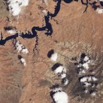
here's another pic I found in an old folder, on an old hardrive. Methinks Forbidding & Bridge canyons ........and Rainbow bridge......kinda left center.....pointing down.....but JFR will know fur sure! Nice high lake level....eh?

😸

View attachment 34726
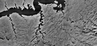
Great shot. The key to figuring out the lake level is to focus on what Oak Bay looks like. Those islands are the giveaway. Not exactly sure when your aerial was taken, but you can compare it to the known dates of certain historic aerials, and more or less figure out the lake level. Yours is definitely a lower lake level than the 9-14-11 aerial, when the lake was at 3655. Also lower than the 6-22-09 aerial, when the lake was at 3638. But it's higher than the 7-29-20 aerial, when the lake was at 3606. As for Trix's hypothesis that the lake is full because he sees water under Rainbow Bridge, I think that "water" is just a shadow.

If you dig back far enough, the best match is an aerial from April 27, 1992, when the lake was at 3621. Here's that aerial:

92-04-27 Oak Bay 3621.jpg
 
Last edited:
Well, my failing vision is just one of several of my infirmities. It just appears to me that the bridge is visible just above end of the water in the canyon. The only map I have handy is Stan Jones and not enough detail to identify the canyon’s twists and turns. Just enjoy contemplating my favorite place on earth.
 
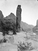
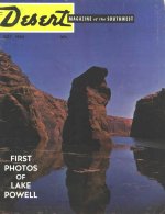
Here are two photos that provide a good tape measure showing the early rise of Lake Powell in 1963. The first shot was taken in 1871, and shows Sentinel Rock at the mouth of Wahweap Creek. The rock is about 300 feet tall. The second shot is from the spring of 1963, and appears on the cover of the July 1963 issue of Desert Magazine. You can see that the lake has climbed about 2/3 the way up the rock, which makes the lake about 200 feet deep at that point. That puts the date of the photo at the very end of May or early June 1963. The top of the rock disappeared completely in the summer of 1964. When the lake is full, the top is 250 feet underwater. Today, it's still about 80 feet underwater....

1871 - Sentinel Rock - E.O. Beaman.jpg63-07 - Desert Magazine Cover - Sentinel.jpg
 
Back
Top