Lake Powell - Photos from the Early Years

Here's an interesting snapshot in time--the cover of a map of the Glen Canyon area from 1955. Look closely, and you can see the road network, such as it was, that served the area. There is still no Page, AZ, no highway from Kanab, and the poor dirt road to Hite Ferry cautions you to "carry water"....
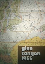
GC Map 1955.jpg
 
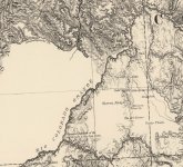
Here are two of the oldest maps of the Colorado River through Glen Canyon. The first is by Clarence King, from 1870, just one year after Powell's first voyage. King had surveyed the land east of the river to some extent, guessed where he could, and left the entire west bank of the Colorado blank. The course of the river itself is sort of guesswork. You'll see a note that says the "supposed junction of the Rio Colorado and Rio San Juan," a position fixed by Powell the year before. You'll also see that King makes no effort to figure out where the Green River meets the Grand to form the Colorado, another position fixed by Powell.

King 1870.jpg

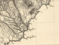
The other map is just as interesting, from 1879. This one was published by Clarence Dutton, a conglomeration of various surveys, including the U.S. Geographical and Geological Survey of the Rocky Mountain Region. This predated the first USGS maps. The interesting thing here compared to the 1870 map is that it makes an effort to survey the land west of the Colorado, but not to the east. What it does include to the west is often erroneous in the details. Take a look at the Escalante River, for example. All that to say, it was a good first effort.

Dutton 1879.jpg

One thing in common both maps share is that they identify the Crossing of the Fathers (“El Vado de los Padres" on the King map)...
 
Last edited:
Back
Top