Lake Powell - Photos from the Early Years

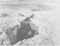
That photo is of what is now the Stateline Auxiliary Ramp. Compare the view in October, 1964, with this picture from 10/18/2021 (scraped from a WW post, but I didn't save the full attribution.)
Agreed, I stand corrected. That’s why the Stateline Aux was so quickly constructed during the last low-water event. The major land movement had already been done back in the 60’s and all that remained after pouring concrete was to build out a lower parking area.
 
Here's an artist's rendering of what the dam and bridge were intended to look like, put together before any construction began. This drawing appeared in the April 1957 issue of Desert Magazine, which hit the stands during the earliest stages of the dam project. It's a pretty close match to what actually happened...

57-04-xx - GCD Artists Rendition.jpg
 
Last edited:
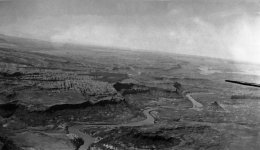
Here's an aerial taken in June 1935 over the upper end of Glen Canyon, with Castle Butte being the most obvious feature at right. This is what Good Hope Bay looks like when the only water in it is the Colorado River. That's Ticaboo Creek coming in from lower left, and Red Canyon in front of Castle Butte heading off the page to the lower right...

1935 - Roger Toll Survey - Castle Butte.jpeg
 
I think it's the overlook. I've had my jeep out there many times (easy drive). Looks like you can see the crevice from Ticaboo Creek just to the north of what I think is the overlook trail. :cool:
 
I was looking at the road like image in the lower left of the frame....the one Squirrel pointed out above. Looks like it runs along the creek bed and terminates in an open area of sand or dirt next to the waters edge. C
 
Great pictures!
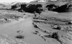
Here's another one that Tad Nichols took in September 1963 down in Wahweap Creek. It's quite significant because it shows the moment (more or less) when the flat water of the reservoir meets the running water in the creek, thus flooding the road to Kane Creek. Nichols and, of course, the many other river runners (including the other two-thirds of We Three) would have travelled that road thousands of times when floating the Green or putting in at Hite without wishing to head further to take out at Lees Ferry.
I think he was there specifically to record that event on film. They say nostalgia ain't what it used to be but Tad obviously felt a pull to be in that place at that time and I thank him for being there. Within minutes he had moved along the track to photograph those first docks being assembled and readied for floating.
The elevation of the reservoir was ~3395 on that day. The sandbar at the mouth of Kane (Crossing of the Fathers) was already under 200 feet of water.
 

Attachments

  • Wahweap Creek.jpg
    Wahweap Creek.jpg
    212.4 KB · Views: 96
Last edited:
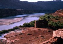
Apologies if this excellent photograph has been posted on here previously. I don't have a credit for it. It appears to show a swollen Colorado river meeting the flat water of a rapidly-rising Lake Powell at the mouth of White Canyon. If that is the case, this picture would have been taken on, or about, June 10th 1964. The reservoir was rising by approximately two feet each day at that time and looking at the condition of the river you can see why. Judging by the tree line, the elevation of the reservoir was ~3450 at that moment. The Hite ferry landings would have already been under several feet of water. Of course, center right is the magnificent Moki fort which would eventually have 150 feet of water above it. That's quite hard to get your head around when looking at this picture!
 

Attachments

  • Fort Moki 1.jpg
    Fort Moki 1.jpg
    208.3 KB · Views: 96
Back
Top