How much do we expect the lake to rise this spring/summer

To add some additional doom, in addition to the current dry forecast, at least the next week calls for warm and wind, perfect conditions to evaporate our existing snowpack. This is scarily similar to what happened in 2002, which turned out to be the worst runoff year on record. In that year a poor but not terrible snowpack was hit by a very dry and windy March and April that led to large scale evaporation of the snowpack before it could melt and run off. On March 15 of that year the forecasted runoff was 4 million acre feet. After the dry and windy spring did its thing runoff ended up being just 1.2 million acre feet. It feels like the worst case scenario for this year keeps getting worse.

Great point on the wind, that can really accelerate evaporation. In my experience, more in the NV/CA deserts than the Rockies, the surface wind forecasts are the least reliable parts of the models which makes for a potential big wild card in how much water could disappear.

As far as temperatures go, the models, including the generally more reliable EPS ensemble, are really ugly the next two weeks with essentially no precipitation of any kind combined with substantially elevated temperatures for the entire forecast period. And yeah, with for now some windy periods. If that comes to pass it's not going to be good.

So USBR still has a few arrows in left the quiver if they choose to use them...

What the USBR does is the most opaque to me right now. From reading all the various documents it seems that they could make a call this month (perhaps after the March 24-Month Study is released) to alter their release plan for the rest of the year. As your excellent analysis shows they've got the potential to protect the lake level at 3525 as they've said is their goal. So if they decide to do that, do we hear about it soon?

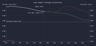
As far as I understand they've already met the requirement to release as little as 6 Maf for the year as recent Minimum Probable forecasts show a level below power pool. That wasn't true at the start of the water year, so at that time they set the operating plan for the year at 7.48 Maf. But if I'm reading things right, they can change that plan if predictions show below power pool levels. What I don't understand clearly is exactly how quickly they can start doing that, but I sort of drew the conclusion that middle of the water year was when they could (i.e. about now). But no one is saying anything at all about this, which seems strange and makes me wonder if I've misinterpreted things.

Also, they never released a January 5 Year Probabilistic Projection which they say they typically do in low water years. Perhaps the 24 Month Study was already dire enough they didn't think they needed the 5 year...
 
What the USBR does is the most opaque to me right now. From reading all the various documents it seems that they could make a call this month (perhaps after the March 24-Month Study is released) to alter their release plan for the rest of the year. As your excellent analysis shows they've got the potential to protect the lake level at 3525 as they've said is their goal. So if they decide to do that, do we hear about it soon?
In 2023, they waited until the April 24-month study to change their release protocol, in that case to increase releases in response to a big runoff. I imagine it will be the same approach this time, only in the other direction, assuming they choose to make a change to decrease releases. If they do, the modified releases would likely start at the beginning of April. That said, they are only planning to release 490 kaf in April, so there's not much wiggle room there. The changes would likely be reflected in their May-July releases...
 
Last edited:
Just to translate these numbers into possible lake levels, here you go. Let's start with the assumption that the USBR does not alter its projected releases from Glen Canyon Dam through the summer, which I have to say are pretty modest by historic standards. We're talking about a release schedule that looks like this:

April - 490,000 af
May - 600,000 af
June - 800,000 af
July - 890,000 af

Total (Apr-Jul) - 2780 kaf

So if we've only got an inflow that might range between 1619-2302 kaf, that tells you the lake is going to drop. How much? Well here's the numbers:

If inflow is 2302 kaf, it would be 3519 on July 31...

...but if inflow is only 1619 kaf, it would be 3506 on July 31. Yikes...

And just for comparison, the USBR's March 2026 24-month study projects just under 3515 on July 31.

So the recent CBRFC forecasts are more or less consistent with the latest USBR projections.

But let's say USBR took extraordinary measures, and reduced releases through GCD each month to no more than 500 kaf. And let's say they ramped up the summer release from Flaming Gorge, which right now is projected to be a total of 292 kaf (Apr-July) to, let's say 400 kaf. That would buy an extra 900 kaf total for Lake Powell in the April-July period. And if that happened, then the range of July 31 lake levels would be 3523-3535. Basically, those moves could buy about 17 feet through the summer.

So USBR still has a few arrows in left the quiver if they choose to use them...
interesting data and analysis. So..., do we really believe the releases will be cut back to 500 kaf for the next at least 6 months? Wonder how that would affect trout habitat in the river in the summer with the heat and water temps. It was a definite issue last spring. And Lake Mead will be OK with that little flow? Really appreciate JFR and DV's data and perspectives.
 
But let's say USBR took extraordinary measures, and reduced releases through GCD each month to no more than 500 kaf. And let's say they ramped up the summer release from Flaming Gorge, which right now is projected to be a total of 292 kaf (Apr-July) to, let's say 400 kaf. That would buy an extra 900 kaf total for Lake Powell in the April-July period. And if that happened, then the range of July 31 lake levels would be 3523-3535. Basically, those moves could buy about 17 feet through the summer.

So USBR still has a few arrows in left the quiver if they choose to use them...
I am pretty sure this is what's going to happen. I just can't see BOR allowing Powell to fall below minimum power pool. The operational, economic and political risk are too high. There is enough water in Mead to absorb the loss of Powell outflow this year and not cause any operational problems down there. Next year? I guess we will see.

Some type of ultimatum from BOR indicating that they won't allow either Mead or Powell to fall below what they consider an operationally safe level, probably 10 to 20 feet above minimum power pool, might be helpful at this point. Something to give the states some motivation to work out a deal if they know there is a day not to far away where they will only get what flows into the system out of the system. Testing this rule in court could also be helpful because I think BOR would win. I don't see a judge ordering them to take the levels lower if they can make a credible argument that doing so threatens the safety of vital infrastructure.
 
So..., do we really believe the releases will be cut back to 500 kaf for the next at least 6 months? Wonder how that would affect trout habitat in the river in the summer with the heat and water temps. It was a definite issue last spring. And Lake Mead will be OK with that little flow?
Not sure how much they'll hold back, but I'm with @ndscott50 on this one--I bet they will hold something back to keep Powell over 3525, or at least close to it. If they hold back as much as I suggested they might from April through July (800 kaf), that would reduce Lake Mead by the same amount, which would drop Mead to 1040 by the end of July (instead of 1052, as currently projected). Lake Mead currently stands at 1065. It can produce power down to 950, although the amount of power diminishes below 1050. It's a tricky balance.

USBR could also reduce deliveries to the lower basin states, and keep the balance in Lake Mead. That would be a more contentious solution.

No matter how much water is released from Powell, it will still be cold coming out of the dam. That said, its slower flow and smaller volume might cause the river to warm slightly as it flows downstream from the dam.... not sure how this will affect the trout habitat there...
 
I have had both....

There could be the trifecta or even worse. "I'm pregnant! The baby's not yours!" (It's some dude that you couldn't even imagine someone with any sense or good taste or decency could possibly be someone someone you <crushed on, loved, fantasized, etc.> could ever pick). Ok, yes, I should be a gothic horror story author in another life...
 
There are many electric utility professionals whose jobs are the planning and operation of western power resources. The 1,320 MW of power from the dam is managed by the Western Area Power Authority. Those folks plan for all contingencies, including the loss of GCD output. GCD’s capacity is important, but for comparison, Arizona’s peak demand is 20,000+ MW. GCD power is primarily distributed to municipalities and cooperative utilities. Their costs will increase as more expensive resources are acquired. But GCD falling to dead power pool will not cause rolling blackouts. That’s my now feeble recollection having retired from the utility business more than a decade ago.
 
Has there been a study done on the ramifications of Glen Canyon Dam not producing any electricity? Are we thinking there's just an increase in cost but alternatives can pick up the slack, or are we talking about rolling blackouts?

There is very little chance the loss of the electricity generated from either power station having a signifcant effect upon the grid. They've vastly expanded power generation with solar, wind, natural gas and battery storage throughout the entire region and they've also added more connections to the various areas to create a regional power organization (WEIM) and are likely to continue adding even more participants as the whole thing works to move extra energy around to the places that need it so they're not wasting as much (search CAISO and WEIM).

@Trix the energy they are likely to be able to get now will cost much less than any newly built hydro or natgas as wind+solar+battery is now often cheaper. anyone building new fossil fuel burners is likely going to be sitting on a stranded asset that is more expensive to run than the alternatives...

the major issue now is not the energy but how to get it distributed and the things slowing that down are the permitting and building of new power lines and connections.
 
Just took a look at the March 2026 Water Supply Briefing from the NOAA-NWS Colorado Basin Forecast Center. Rather than rehashing a bunch of technical data, it is probably best to simply provide their summary conclusions:
  • The 2025–26 meteorological winter (December–February) was the warmest winter on record for vast swaths of the Colorado River basin.
  • Persistent high pressure was a strong contributing factor, which also resulted in very dry conditions.
  • March 1 SWE is at/near record low at many SNOTELs (40-50 year period of record).
  • The 2-week weather forecast is favoring warmer/drier conditions and is expected to lead to further declines in the water supply outlook
Based on this analysis projected inflow for Lake Powell is 2300 kaf, with a maximum upper bound of 4300 kaf, and a maximum lower bound of 950 kaf. Given current forward-looking weather model projections, it is likely we will deviate more toward the lower bound in the weeks ahead. Recall that the worst inflow ever recorded was 964 kaf in 2002. We still have a distinct possibility of beating that on the downside.

To say that this assessment is grim is an understatement. At this point the Colorado River basin is simply out of water. The Era of Limits has arrived in the American West.
 
Yep, the coming weather is brutal!

The March 24 Month Study was just released today and it is fairly irrelevant at this point. It looks about like the February study because the March 1st runoff estimate it is built on was only slightly worse than the February 1st. Unfortunately in the two weeks since that March 1st estimate things have gotten quite a bit worse. But for completeness, here it is:

Powell24MS.png

The blue "Probable Maximum" is entirely fictional at this point, it is based on the January numbers because they don't bother updating the maximum forecast every month when they are only concerned about the low end.

The green "Most Probable" is based on the March 1st CBRFC official forecast. The CBRFC in their recent webinar already mentioned the March 1st forecast was almost immediately invalidated by a change in the forecast to much drier and hotter weather just after they issued it.

The above green line is based on a spring runoff of 2300 kaf. As of today, the forecast spring runoff is only 1600-1700 kaf depending on which forecast you use for the next week of temperatures and precipitation (i.e. the bad one or the super bad one).

The red "Probable Minimum" likely has not changed very much, the bottom end of the CBRFC forecasts does not change as dramatically as the 50% numbers.

Here is the current doom out of the CBRFC:

Screenshot 2026-03-16 at 2.38.30 PM.png
This run uses the GEFS ensemble to forecast temperatures and precipitation for the coming days and then uses climatology after that. You can see it is a "noisy" forecast because a multi-day forecast like GEFS tends to bounce around a bit on its own (we all know "10 day forecasts" are pretty worthless).

The bottom end are terrifyingly bad numbers which hopefully won't come to pass. That "ESP Min" for example uses GEFS for the coming days and then uses the worst case weather ever observed, so a true "perfect storm" unlikely to occur. But that "ESP 70" number at just 1214 kaf is what will occur if we are only as bad as the 30% worst weather - a fairly probable occurrence.

Lastly recall that BoR does have the ability to reduce outflows from Lake Powell. So while the curves above show the lake dropping rapidly they are based on the assumption that 7.48 Maf will be released this water year. That is almost certainly not going to be the case at all. At this point we just don't have any information as to exactly how BoR will change the releases this summer.
 
The bottom end are terrifyingly bad numbers which hopefully won't come to pass. That "ESP Min" for example uses GEFS for the coming days and then uses the worst case weather ever observed, so a true "perfect storm" unlikely to occur. But that "ESP 70" number at just 1214 kaf is what will occur if we are only as bad as the 30% worst weather - a fairly probable occurrence.

I've never actually lived in the Colorado River basin, but as a lover of the intermountain west and southwest, have sort of kept tabs on the diminishing storage and flow situation from afar for quite a while. I checked in on the water database about a month ago and haven't been able to stop digging into the data since.

I started with charts from the NWCC Average Temperature, Snow Water Equivalents, and Precipitation data for the upper Colorado River Basin that allow for a water-year day comparison of current to previous years.

Average Temperature:
2026 year-to-date is warmer than the previous warmest year by 2.3 degrees F.

At one point, on January 7, over a 30 day rolling average, 2026 was 5.1 degrees F warmer than any previous year. That is unheard of.

Screenshot 2026-03-16 at 3.12.37 PM.png

Precipitation:
2026 is below average, but not an outlier.
Screenshot 2026-03-16 at 3.40.09 PM.png

Snowpack Water Equivalents:
2026 is at an all time low, more than 15% below 2002. There have been some low snowpack years at this point in the season that have had late season snow accumulations, like 2013, but that's difficult to envision given the outlier average temperatures of 2026 to date. The discrepancy between below average precipitation and way below average snowpack suggests that precipitation has fallen as rain instead of snow, which makes sense given the outlier temperatures.

Screenshot 2026-03-16 at 3.41.55 PM.png


Lastly recall that BoR does have the ability to reduce outflows from Lake Powell. So while the curves above show the lake dropping rapidly they are based on the assumption that 7.48 Maf will be released this water year. That is almost certainly not going to be the case at all. At this point we just don't have any information as to exactly how BoR will change the releases this summer.

After assessing climate data, I put together a chart that projects previous water year inflows from the current day and conditions of Lake Powell. It's an attempt at using actual data from previous years to project Lake Powell from the outlier snowpack data from this year. As the values of today, March 16, only 2002 and 2018 were within 20% of this year's snowpack water equivalent for the Upper Colorado River Basin.

You can adjust Lake Powell release scenarios to affect the projections. As far as I can tell, the current release "plan" is 7.48 MAF, but the current lowest possible is 6.0 MAF based on this 2024 Record of Decision update to the 2007 Interim Guidelines. The chart lets you adjust based on applying a handful of release scenarios to inflows extrapolated from previous water years.

One caveat is that I've yet to add in the other components of the water balance equation like evaporation and bank storage.
Screenshot 2026-03-16 at 3.59.22 PM.png

That's probably enough for now. This is all a work in progress, and hopefully sheds light on some of those projected 2026 inflow volumes and variations linked by DVexile.
 

Attachments

  • Screenshot 2026-03-16 at 3.46.21 PM.png
    Screenshot 2026-03-16 at 3.46.21 PM.png
    164.2 KB · Views: 7
Last edited:
I've never actually lived in the Colorado River basin, but as a lover of the intermountain west and southwest, have sort of kept tabs on the diminishing storage and flow situation from afar for quite a while. I checked in on the water database about a month ago and haven't been able to stop digging into the data since.

I started with charts from the NWCC Average Temperature, Snow Water Equivalents, and Precipitation data for the upper Colorado River Basin that allow for a water-year day comparison of current to previous years.

Average Temperature:
2026 year-to-date is warmer than the previous warmest year by 2.3 degrees F.

At one point, on January 7, over a 30 day rolling average, 2026 was 5.1 degrees F warmer than any previous year. That is unheard of.

View attachment 35165

Precipitation:
2026 is below average, but not an outlier.
View attachment 35166

Snowpack Water Equivalents:
2026 is at an all time low, more than 15% below 2002. There have been some low snowpack years at this point in the season that have had late season snow accumulations, like 2013, but that's difficult to envision given the outlier average temperatures of 2026 to date. The discrepancy between below average precipitation and way below average snowpack suggests that precipitation has fallen as rain instead of snow, which makes sense given the outlier temperatures.

View attachment 35167


After assessing climate data, I put together a chart that projects previous water year inflows from the current day and conditions of Lake Powell. It's an attempt at using actual data from previous years to project Lake Powell from the outlier snowpack data from this year. As the values of today, March 16, only 2002 and 2018 were within 20% of this year's snowpack water equivalent for the Upper Colorado River Basin.

You can adjust Lake Powell release scenarios to affect the projections. As far as I can tell, the current release "plan" is 7.48 MAF, but the current lowest possible is 6.0 MAF based on this 2024 Record of Decision update to the 2007 Interim Guidelines. The chart lets you adjust based on applying a handful of release scenarios to inflows extrapolated from previous water years.

One caveat is that I've yet to add in the other components of the water balance equation like evaporation and bank storage.
View attachment 35170

That's probably enough for now. This is all a work in progress, and hopefully sheds light on some of those projected 2026 inflow volumes and variations linked by DVexile.
That's really excellent work! Thank you!
 
Thank you. I've gleaned a lot reading your posts on here.

Lake Powell / Glen Canyon is truly at the epicenter of an incredibly dynamic and important watershed. I've learned a lot attempting to put together tools to help myself understand the basics of the situation, and feel like I've only scratched the surface.

In trying to understand this, I've managed to amass a ton of data from the USBR, USGS, NOAA, and the NWCC. If there's something that would help illuminate things that isn't readily available, I'm all ears.

For instance, one piece of the puzzle that I found helpful was putting Lake Powell in the context of upstream storage:

Screenshot 2026-03-16 at 4.54.54 PM.png
 
I like that website :) Puts the whole basin into perspective. It's amazing to think that arguably one of the largest infrastructure projects in recent history--- controlling every drop of water on the NA continent, occurred from the mid 30s to the mid 70s. TVA, BoR, USACE et al.... 4 decades changed the entire show, 1/2 a lifetime. Don't know why I felt the need to say that haha, but the more I think about the scope of and impact of that -- many impacts and many scopes -- the more staggering it becomes.
 
There are many electric utility professionals whose jobs are the planning and operation of western power resources. The 1,320 MW of power from the dam is managed by the Western Area Power Authority. Those folks plan for all contingencies, including the loss of GCD output. GCD’s capacity is important, but for comparison, Arizona’s peak demand is 20,000+ MW. GCD power is primarily distributed to municipalities and cooperative utilities. Their costs will increase as more expensive resources are acquired. But GCD falling to dead power pool will not cause rolling blackouts. That’s my now feeble recollection having retired from the utility business more than a decade ago.
I can agree with Trix, and I only retired from the utility business about 6 years ago. The municipal utilities that contract for GCD output all have clauses in their contracts that say that WAPA can buy on the open market to replace any shortfalls in GCD generation, and pass those market prices through to the customers. There were a few years when the market price was actually cheaper than the GCD cost, and the munis were paying more for the GCD contract energy than if they had been free to go buy on the open market for themselves. Bottom line is that turning off GCD would have a minimal impact on reliability because there's plenty of generation in the western grid, and a small but noticeable effect on cost, most of which would be felt by municipal utility customers.
 
Back
Top