
You are using an out of date browser. It may not display this or other websites correctly.
You should upgrade or use an alternative browser.
You should upgrade or use an alternative browser.
Stateline Ramp this morning
- Thread starter Marina Bum
- Start date


Marina Bum
Escalante-Class Member
A person from our group who was on the beach with us ground up an expensive prop in that very same area when he launched there day before yesterday. It was a fixed prop inboard so not much you can do about it in that area, be careful.Stateline aux ramp is at the boiler players. Super sketchy to the south, about the 9’ to the north of the curtsey dock there is about a 2’ deep and 3’ wide gap between the plates, saw a few trailers drop off and pop their tires.
Last edited:

Rainbowbridge
Keeper of San Juan Secrets
Ouch....props, struts, rudders.....A person from our group who was on the beach with us ground up an expensive prop in that very same area when he launched there day before yesterday. It was a fixed prop inboard so not much you can do about it in that area, be careful.

When I see the photos of the inboards launching at the old dirt ramp before Wahweap.....and before depth finders.....
Wow, those intrepid souls were more brave than moi......


jimmybame
Well-Known Member
I’m launching a sailboat Tuesday night any suggestions besides checking it out first thanks for the heads upStateline aux ramp is at the boiler plates. Super sketchy to the south, about the 9’ to the north of the curtsey dock there is about a 2’ deep and 3’ wide gap between the plates, saw a few trailers drop off and pop their tires.


sphoppie
Active Member
Stay to the north as much as you ca, look at the plates before you launchI’m launching a sailboat Tuesday night any suggestions besides checking it out first thanks for the heads up
Marina Bum
Escalante-Class Member
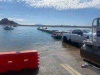
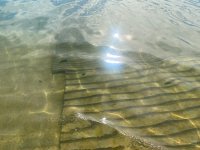
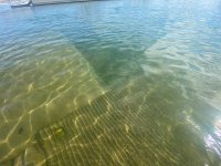
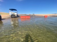
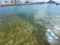
Photos from 10:30 this morning, Tuesday July the Seventh. Park Service was out filling these barricades with water, behind those maybe 20 feet out is the drop off end of the concrete ramp. Those are the spots that have reportedly been eating trailers and props. As long as you go straight back anywhere it’s not barricaded up there is boiler plate maybe 40 feet out.
Last edited:

Tiff Mapel
Escalante-Class Member
Thank you for the pics. I'm coming down today and launching my Boston Whaler this afternoon. I'll let you all know how it goes. My team and I will be doing our "Rogue" Trash Tracker trip. Since there's not an official program this season, we're using my boats. We'll be based out of Wahweap Bay somewhere. So if you see four of us hiking around lugging trash bags, that'll be us!
Tiff
Tiff

Bill Sampson
Keeper of San Juan Secrets
Thank you TiffThank you for the pics. I'm coming down today and launching my Boston Whaler this afternoon. I'll let you all know how it goes. My team and I will be doing our "Rogue" Trash Tracker trip. Since there's not an official program this season, we're using my boats. We'll be based out of Wahweap Bay somewhere. So if you see four of us hiking around lugging trash bags, that'll be us!
Tiff
So what happens once we reach the end of the current 40 feet of boiler plate? Can another 40-foot section be added, or is that effectively the end of the road?
Right now the lake is dropping roughly 3–4 feet per month without any additional Flaming Gorge (FG) releases. That would put the lake about 6 feet lower by September 1 and approximately 8–9 feet lower by October 1.
I imagine the immediate focus is simply making it through this summer. Next spring feels so far away that it's probably not getting much attention yet from the boat ramp team.
But what happens if there is little or no runoff this winter? Once the emergency Flaming Gorge water is gone, there is no reserve left. There is no magic solution waiting in the wings.
By next spring, boat ramp access may actually become a secondary concern compared to bigger issues like survival and navigation. As the lake continues to fall, new islands, shoals, and rock hazards will emerge throughout Wahweap Bay. One recent post on another Powell forum estimated that as many as 26 new islands could appear between the main channel near Glen Canyon Dam and the Wahweap rental docks by April 1. The accompanying satellite image already shows well over a dozen shallow areas that appear ready to break the surface. That same analysis suggested portions beneath the Wahweap Marina are already only about 30 feet deep.
If we receive little or no runoff this winter, could Wahweap Marina realistically remain where it is next summer? Or would relocating operations to Halls become the only practical option? Where else is there sufficient water depth, road access, utilities, parking, and support infrastructure? Antelope Point presents obvious challenges, including private ownership, existing utility capacity, parking limitations, and access constraints.
Even if engineering efforts and additional Flaming Gorge releases reduce the decline to only 2 feet per month, the lake would still fall another 16 feet by April. At 3 feet per month, the drop would approach 24 feet by spring. Either scenario represents a very serious threat to Wahweap's long-term viability.
How much usable water depth actually remains behind the boiler plates? Is there still 30 feet of water, and does the lake bottom continue with a gradual slope that would allow additional boiler plate sections to be installed over the next year if necessary?
Has anyone conducted a detailed sonar survey throughout Wahweap Marina to map the remaining depths and identify where the next islands and shoals are likely to emerge? That information would provide a much clearer picture of what the marina may be facing over the coming months.
Looking at recent satellite imagery, Warm Creek also appears to be approaching a critical point. Near Buoy 12, the access channel now looks more like a narrow thread than a navigable channel. Years ago, the three-way junction was broad and open. What does that channel actually look like today?
Has Wahweap Marina shared any official long-term strategy, or is the current focus simply getting through August 31 and evaluating conditions from there?
If this winter produces little runoff and Wahweap Bay continues to decline through next spring, what realistic options remain for Wahweap Marina? Beyond hoping for a wet winter, what practical paths forward actually exist?
Has Halls ironed out all the bugs from the Bullfrog merge or are they still neck deep in chaos.
I think I took Lake Powell for granted for too long - I never ever thought we would ever be living this and discussing this.
A few years ago we had a miracle and it only extended marina life by 3 years - do you see that miracle happening every three years to keep the ball rolling, if not the people at the lake are screwed and that is nothing in comparison to the next cliff impacting society, a big part of our country known as the southwest. - You think there are good deals on houseboats, what happens when entire communities run out of water… that is what is around the next corner - communities collapsing.
Right now the lake is dropping roughly 3–4 feet per month without any additional Flaming Gorge (FG) releases. That would put the lake about 6 feet lower by September 1 and approximately 8–9 feet lower by October 1.
I imagine the immediate focus is simply making it through this summer. Next spring feels so far away that it's probably not getting much attention yet from the boat ramp team.
But what happens if there is little or no runoff this winter? Once the emergency Flaming Gorge water is gone, there is no reserve left. There is no magic solution waiting in the wings.
By next spring, boat ramp access may actually become a secondary concern compared to bigger issues like survival and navigation. As the lake continues to fall, new islands, shoals, and rock hazards will emerge throughout Wahweap Bay. One recent post on another Powell forum estimated that as many as 26 new islands could appear between the main channel near Glen Canyon Dam and the Wahweap rental docks by April 1. The accompanying satellite image already shows well over a dozen shallow areas that appear ready to break the surface. That same analysis suggested portions beneath the Wahweap Marina are already only about 30 feet deep.
If we receive little or no runoff this winter, could Wahweap Marina realistically remain where it is next summer? Or would relocating operations to Halls become the only practical option? Where else is there sufficient water depth, road access, utilities, parking, and support infrastructure? Antelope Point presents obvious challenges, including private ownership, existing utility capacity, parking limitations, and access constraints.
Even if engineering efforts and additional Flaming Gorge releases reduce the decline to only 2 feet per month, the lake would still fall another 16 feet by April. At 3 feet per month, the drop would approach 24 feet by spring. Either scenario represents a very serious threat to Wahweap's long-term viability.
How much usable water depth actually remains behind the boiler plates? Is there still 30 feet of water, and does the lake bottom continue with a gradual slope that would allow additional boiler plate sections to be installed over the next year if necessary?
Has anyone conducted a detailed sonar survey throughout Wahweap Marina to map the remaining depths and identify where the next islands and shoals are likely to emerge? That information would provide a much clearer picture of what the marina may be facing over the coming months.
Looking at recent satellite imagery, Warm Creek also appears to be approaching a critical point. Near Buoy 12, the access channel now looks more like a narrow thread than a navigable channel. Years ago, the three-way junction was broad and open. What does that channel actually look like today?
Has Wahweap Marina shared any official long-term strategy, or is the current focus simply getting through August 31 and evaluating conditions from there?
If this winter produces little runoff and Wahweap Bay continues to decline through next spring, what realistic options remain for Wahweap Marina? Beyond hoping for a wet winter, what practical paths forward actually exist?
Has Halls ironed out all the bugs from the Bullfrog merge or are they still neck deep in chaos.
I think I took Lake Powell for granted for too long - I never ever thought we would ever be living this and discussing this.
A few years ago we had a miracle and it only extended marina life by 3 years - do you see that miracle happening every three years to keep the ball rolling, if not the people at the lake are screwed and that is nothing in comparison to the next cliff impacting society, a big part of our country known as the southwest. - You think there are good deals on houseboats, what happens when entire communities run out of water… that is what is around the next corner - communities collapsing.

Trix
Keeper of San Juan Secrets
You have articulated concerns we all have. To put in context of this broader discussion, you could move your post to this thread.

I know a lot of us watch the daily water level and data that David posts. It looks like the lake is dropping a foot a wk now. I have a couple of wks planned on the lake in August, one mid month and one late month. Is the lake going to be down to 3520 by late August? Or are there plans to decrease the outflow at the dam? Or increase releases again from Flaming Gorge? At what level will these changes start?
- doc
- Replies: 18
- Forum: Lake Powell Issues

RichieW13
Well-Known Member
As the lake continues to fall, new islands, shoals, and rock hazards will emerge throughout Wahweap Bay.
Isn't this always an issue at Powell? Whether water is rising or falling it is creating new rock hazards.

fish&peace
Well-Known Member
It is for us,thats why you have to know where you are and watch wtf you are doing!!Isn't this always an issue at Powell? Whether water is rising or falling it is creating new rock hazards.
Marina Bum
Escalante-Class Member
@ Bubba, nice to hear from you again, it’s been a minute.
The Auxiliary ramp can go as low as 3450, the plan was to keep adding onto it chasing the receding water just as they did last time. The extension of Antelope public ramp has been approved and is getting under way with plans to take that ramp to 3490. That project is supposed to have a target for completion of June 1st of 2027. Soon we may all be launching there as a better alternative to low waters in Wahweap, or not.
In my estimation BOR is doing everything they can to keep water levels above dead power pool at 3490 up to an including keeping, as a buffer, the last three MAF between dead power pool and dead pool. (That is not yet official, it’s based on what I’m hearing and seeing) I don’t think they want to manage the reservoir from dead pool, it limits their options way to much.
Letting the levels fall to Dead Pool would also kill any semblance of recreation as we know it and it would have other unintended consequences as well beyond that. I also don’t think it’s a coincidence that the new depth of the ramp at Antelope is also the minimum power pool level. Does the BOR and Park Service know something we don’t? Probably, I think extending the ramp there is a good idea since it’s right on the channel in deep water especially if 3490 becomes the new minimum.
The Auxiliary ramp can go as low as 3450, the plan was to keep adding onto it chasing the receding water just as they did last time. The extension of Antelope public ramp has been approved and is getting under way with plans to take that ramp to 3490. That project is supposed to have a target for completion of June 1st of 2027. Soon we may all be launching there as a better alternative to low waters in Wahweap, or not.
In my estimation BOR is doing everything they can to keep water levels above dead power pool at 3490 up to an including keeping, as a buffer, the last three MAF between dead power pool and dead pool. (That is not yet official, it’s based on what I’m hearing and seeing) I don’t think they want to manage the reservoir from dead pool, it limits their options way to much.
Letting the levels fall to Dead Pool would also kill any semblance of recreation as we know it and it would have other unintended consequences as well beyond that. I also don’t think it’s a coincidence that the new depth of the ramp at Antelope is also the minimum power pool level. Does the BOR and Park Service know something we don’t? Probably, I think extending the ramp there is a good idea since it’s right on the channel in deep water especially if 3490 becomes the new minimum.
Last edited:

JFRCalifornia
Keeper of San Juan Secrets
The most drastic management measure USBR could take is to do what they did in 1963 when the lake was filling—reduce outflows through the dam to 1000 cfs. That would of course have major downstream consequences to flow through the Grand Canyon, storage in Lake Mead, and lower basin water use. And of course almost no power generated through the dam. But it would certainly stabilize Powell in the short term…
Last edited:
Marina Bum
Escalante-Class Member
Thank you JFR! The Park Service directors here have been talking about the “Return to the Riparian Environment” where “what flows in flows out” for some time now. If BOR were to keep the three million acer feet between dead power pool (3490) and internal tunnels dead pool (3470) the same thing could apply; What flows in can flow out only through the turbines. I don’t think BOR, Park Service or the Government are ready just yet to let the reservoir go. Otherwise why would they be spending over a hundred million dollars to take the Antelope ramp to 3490? And why 3490? Why not 3450 if we are headed there or worse?The most drastic management measure USBR could take is to do what they did in 1963 when the lake was filling—reduce outflows through the dam to 1000 cfs. That would of course have major downstream consequences to flow through the Grand Canyon, storage in Lake Mead, and lower basin water use. And of course almost no power generated through the dam. But it would certainly stabilize Powell in the short term…
To me it’s not so much about saving lake Powell as a return, if needed, to “a riparian environment where what flows in flows out” only through the normal reliable high capacity works. Like you said low outflows have been done before but if it’s passing on what you get it’s a natural deal, if they do this it’s kind of a having their cake and eating it too situation.
If we loose power pool we loose the ability to make power and there will be a brain drain on how to maintain and run the turbines. The marinas will go away and so will all those folks who know how to run them and then there are the communities around the lake that will have a setback for a time. In the end we’d loose so much of the physical and human infrastructure that makes boating here possible that it could take a long time to recover if the lake ever came back.
Last edited:
fish&peace
Well-Known Member
Is the sky falling? It is flooding again in the East,they brought Oil from AK,surely you could bring water from a Missisippi boardering state. If you look at an air map (simplest to read) it is all down hill from Albuquerque (more or less),and what about invasive species? that would be us !! Do yous want water or not?? Lets do something even if it's wrong.
Is the sky falling? It is flooding again in the East,they brought Oil from AK,surely you could bring water from a Missisippi boardering state. ...
This has been covered many times already. The idea is way too expensive and there are better ways of dealing with the problem.
