
You are using an out of date browser. It may not display this or other websites correctly.
You should upgrade or use an alternative browser.
You should upgrade or use an alternative browser.
Snow
- Thread starter TR.
- Start date
- Status
- Not open for further replies.


Sherrie (prev MB 2000)
Well-Known Member
I’m partial to snow at Keystone ski area in Colorado both to ski on in the winter and then to boat on at Lake Powell in the summer.
The Mon-Tues December 12-13 storm is projected to drop 10”-15” there.
We stayed in Keystone for the first week of March 2020 and had 7 feet of snow in 7 days. That’s the kind of snow we need for Powell. While great, these not-yet-even-winter snows seem to me to have a lot of evaporation loss.
But enough of them can help protect the ground from drying out more. The last few years the continental divide mountains have been all but bare as I’ve driven over to ski. It’s been really bad.
I will give you my uneducated snow status report for how the mid-Colo Rockies are looking for mid-December as soon as I get my hiney up to ski — hopefully later this week.
The Mon-Tues December 12-13 storm is projected to drop 10”-15” there.
We stayed in Keystone for the first week of March 2020 and had 7 feet of snow in 7 days. That’s the kind of snow we need for Powell. While great, these not-yet-even-winter snows seem to me to have a lot of evaporation loss.
But enough of them can help protect the ground from drying out more. The last few years the continental divide mountains have been all but bare as I’ve driven over to ski. It’s been really bad.
I will give you my uneducated snow status report for how the mid-Colo Rockies are looking for mid-December as soon as I get my hiney up to ski — hopefully later this week.
Last edited:
Colorado Expat
Well-Known Member
Like many atmospheric river events that we saw last year, this one is having a strong impact in northern California and the Pacific northwest, but then following a more typical La Nina omega pattern and tracking too far north to bring really big snowfalls to the southern and central Rockies that feed the Colorado River basin. In Colorado it looks like a moderate snowfall event at best (the heaviest snow totals potentially occurring on the eastern plains rather than in the mountains as the system dives back south), with perhaps some better accumulation in the upper Green River basin of northeastern Utah and western Wyoming. But California can definitely use the snowpack accumulation in the Sierra, and they are going to get it, at least in the northern half of the range.Well, I can tell you here on the central CA coast we are getting slammed right now and all weekend, best guess it will end up somewhere around 3+ inches of cold rain in 2 days, with more ahead... hopefully that translates well farther east.
Sherrie (prev MB 2000)
Well-Known Member
Expat, it’s my understanding the Colo River Basin gets less moisture in La Niña years which are generally caused by higher ocean surface temps in the Southern Pacific. Because our weather patterns are influenced by those ocean temps, forecasters are able to let us know whether to expect La Niña or El Niño moisture.
Does my understanding sound right to you?
Does my understanding sound right to you?
Colorado Expat
Well-Known Member
The correlation between El Nino or La Nina events and winter snowpack in the Colorado River basin is not absolute, but in general a La Nina pattern, which is characterized by a large mass of cool water at the surface in the equatorial East Pacific ocean area, tends to match up with lower snowfall years more often than not. The El Nino and La Nina phases alternate over time in what are called ENSO cycles, often with a somewhat ENSO-neutral period in between. Most La Nina episodes only last for 1 or 2 years, then fade. In this case, the current La Nina is now going strong into a third successive winter, which is unusual. This is one of the reasons why BOR is so concerned about how they are going to maintain even minimum hydro pools at both Glen Canyon and Hoover dams going into 2023. Another dry La Nina winter, if that is what occurs, will really make things difficult for them, and might even force them to choose which hydro plant to idle. At the moment we are still in the early stages of winter, and anything can happen. But if you are playing the odds, then the money is on another sub-par runoff year coming up, and BOR certainly understands this.Expat, it’s my understanding the Colo River Basin gets less moisture in La Niña years which are generally caused by higher ocean surface temps in the Southern Pacific. Because our weather patterns are influenced by those ocean temps, forecasters are able to let us know whether to expect La Niña or El Niño moisture.
Does my understanding sound right to you?
Sherrie (prev MB 2000)
Well-Known Member
… but in general a La Nina pattern, which is characterized by a large mass of cool water at the surface in the equatorial East Pacific ocean area, tends to match up with lower snowfall years more often than not.
Thanks for the clarification — much appreciated.
Most La Nina episodes only last for 1 or 2 years, then fade. In this case, the current La Nina is now going strong into a third successive winter, which is unusual. This is one of the reasons why BOR is so concerned about how they are going to maintain even minimum hydro pools at both Glen Canyon and Hoover dams going into 2023. Another dry La Nina winter, if that is what occurs, will really make things difficult for them, and might even force them to choose which hydro plant to idle.
Thanks for the additional insight as to the implications - although very sad, also much appreciated.

Todd
Escalante-Class Member
And our forcast in GJ was 1~3 inches and we got a big NOTHING.Well our forecast was actually exactly right for once. Flagstaff, AZ got 8 inches of the fluffy white stuff. Heck yah
Glad you got it Travis!

Bill Sampson
Keeper of San Juan Secrets
Prescott Valley Arizona has probably gotten a foot between yesterday and today


Dorado
Keeper of San Juan Secrets
Unfortunately, the wet cycle we have been in is about to be replaced by high pressure. Let’s hope it is short lived and doesn’t park over the west for 3 months like it did last winter! At the end of December last year we had a big snowpack, but in January and February it was dry, when the snowpack should have been increasing the most…
Finger crossed this just a short term pattern this year!!!
Finger crossed
this just a short term pattern this year!!!Boatingtopgun
Active Member
In Boulder and Longmont, we got nothing out of this storm. However, the eastern plains got raked with blowing snow and 60 MPH winds.

FishnFly
Well-Known Member
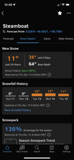
Steamboat is reporting 25 inches over the past 48 hours and they are forecasted to receive another 25 inches next Thursday and Friday (hope that forecast holds). Just wish it would snow like that on every mountain in the state. Beggars can’t be choosers…I guess. It’s uplifting to see the snow pack where it is at this time. Keep up the snow dancing!Vail ended up with another 10" and is expecting more today. They are seating at 117" on the Year and average 230" for the year. For the month of Nov and Dec they Average 80" so doing well this year so far. Hope it keeps up.

FishnFly
Well-Known Member
Agreed. I was super bummed that the storm fizzled out for the most part. I was mistaken on Steamboat. They’ve had 36 inches in the past 72 hours!Unfortunately this past storm was a bust for Summit County however we are still crushing it so far.
Attachments

Squirrel
Keeper of San Juan Secrets
- Status
- Not open for further replies.