Projected Bullfrog North Ramp Closure Date

Status
Not open for further replies.
I don't know why they can't chase the bottom of the Bullfrog north ramp extension with ramps as well. It puts a lot of houseboats in jeopardy to not have a way to retrieve the boat.
I am pretty sure there is no depth out in front of the ramp to "chase". As I remember, the bay out front is too flat and shallow, according to the reports of other WW boaters this spring...
 
When I went in October it didn't seem to be quite what I expected with respect to slow out from the ramp. I was expecting something much more shallow and found it quickly dropped to 20-30 feet by the end of the courtesy dock. That would leave at least a little room for bringing things down over the next 4-6 months to allow larger boats to launch off of plates. I think the Diesel Brother's big PT Boat was launched off that ramp before it was officially open.
 
If I have a vote, I would rather have them pursue a new ramp in a different location. Something that could be used for the next several years should the drought persist.

I thought that was the anticipated plan?
That is the plan. They have outlined plans for launch ramps at Stanton Creek along with an extension of the Hall's ramp in their top secret Jacobs planning document. Meanwhile, I am looking at pictures of a sunk houseboat at Wahweap and thinking about what would happen if any boat sprung a leak at the north end of the lake and needed to be pulled. It would be awful nice to have plates in the water to allow launching and retrieval down to 3510 or 3515 instead of discontinuing at 3529.
 
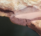
Extending Halls Ramp would be quite the endeavor...

View attachment 20177

Is it possible to extend / utilize the ferry terminal for launching smaller boats snice it is no longer running?
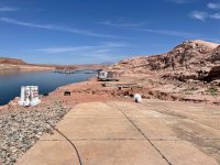
I know we have all seen this picture, but it doesn't really look like that. The view from the ramp is like this:
IMG_6385.jpeg

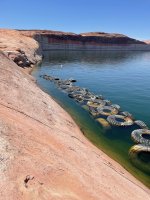
The Jacobs plan has the ramp switching back and heading down lake along the wall on this face:

IMG_6383.jpeg

I think it will be very expensive to make the ramp there blasting through the rock, but I can't see what is down lower. It would seem simpler to me also to get into the ferry ramp for future ramp extension.
 
I don't know why they can't chase the bottom of the Bullfrog north ramp extension with ramps as well. It puts a lot of houseboats in jeopardy to not have a way to retrieve the boat.
See on the internet there are some companies selling boat emergency floats (airbags) - even offering heavy duty applications designed to keep large ships from going completely under. Seems like the North Lake marina should have some on hand to keep a boat in a slip or mooring ball floating, since they can no longer offer a ramp for retrieving a boat that might be in trouble.
 
Weekly Update:
2.26 feet to go as of yesterday at current rate of decline of .09 ft/day. Looks like closure just after the first of the year(1/2/23). Still fairly warm in lower elevations, so a good wet southern storm could slow the rate of decline. Contact your congressman and the new NPS director to move forward with a Stanton launch option. Halls Crossing would be a bonus, but development costs of both locations(existing ramp, or ferry access) will be high relatively. Ferry canyon would require a new parking lot(where?), and existing ramp will require a lot of fill material(how do you compact new material with the end under water).
 
Weekly Update:
1.95 feet remaining at current rate of decline of .09 ft/day, puts closure still at 1/2/2023. Inflows have been somewhat sporadic, but the average has held consistently at .09ft/day for about two weeks. A warm spell could melt snow in the lower elevations around the basin and prolong the use of the ramp.
 
I need a refresher… why is 3525 the number? End of cement at that level? End of usable submerged cement? End of boiler plate level?

With that closure will they start allowing more launch at your own risk again down past the main ramp area? Sorry for my ignorance, maybe this has been explained here or in the park announcements before. Thanks

Preston
 
I need a refresher… why is 3525 the number? End of cement at that level? End of usable submerged cement? End of boiler plate level?

With that closure will they start allowing more launch at your own risk again down past the main ramp area? Sorry for my ignorance, maybe this has been explained here or in the park announcements before. Thanks

Preston
If I remember correctly, it was the end of the usable ramp with gravel put down. However, i do remember folks launching on that ramp when it was a few feet lower than 3525.

What I'm really interested in though is the dirt area off the main ramp for small boats. It would be great to see them smooth an area out and throw some gravel down there as the water goes down. wishful thinking i know....

Edit: found link from old post. refer to pages 19 and 20

 
Last edited:
We launched on May 4th down past the main ramp and past the big break tires and the level was 3522ish. So there should be some launching available past the first of the year. Problem is there is ZERO communication/news/plans etc. that I see. Have a trip tentatively planned for January 14th-15th and need a spot lol.

Or I need to finish up my Blue Notch Rig sooner. Have had the trailer done for a while now, but had to start on a different boat that was more stable after some tests.
 
Problem is there is ZERO communication/news/plans etc. that I see
The first WW reported motorized launch on the extended Executive ramp was on April 28th at an elevation of 3522.64. This was a bass boat launched before boiler plates had been placed. It was noted in the post that the closure barricades were still standing at the top of the ramp. The ramp will "close" shortly after the first of the year, and I suspect the dirt ramp below the main ramp will start getting use again. With declining water levels exposing mud, this may be more difficult than with water rising, but time will tell. Looking at the photos of the dirt ramp there are some rock protrusions in the area so it might be okay. I too wish that NPS would move forward with the Stanton launch plan if for no other reason than to improve the road that accesses the Stanton area, but I'm not sure of the status on any of the ramp extensions referenced in that earlier post(I'll try and find it again for everyones reference). We took a weekend camping trip to Antelope Point RV Park over Thanksgiving weekend because I plan on launching our Cabin Cruiser down there this spring and I wanted to familiarize myself with Stateline/Wahweap/etc. The last thing I want to do is bury a semi and 30' Cruiser in the middle of the only launch on the North. Since we're a few weeks from ramp closure, maybe we can get some photos of the dirt launch below the main bullfrog ramp for current status?
 
Status
Not open for further replies.
Back
Top