
You are using an out of date browser. It may not display this or other websites correctly.
You should upgrade or use an alternative browser.
You should upgrade or use an alternative browser.
North Lake observations
- Thread starter jeeps72
- Start date
- Status
- Not open for further replies.
Man, does reading some of these posts bring back memories, the cut between BF Bay and Halls I have run lots of times. I can remember pulling up to the "super market" and walking only a few steps to get inside. I remember the ice cream and pizza. That goes back some.
Another memory is a Golden eagle feeding two little ones on a steep slope, my boys the oldest over 50 now says that is one of their favorite memories.
Thanks you guys
Another memory is a Golden eagle feeding two little ones on a steep slope, my boys the oldest over 50 now says that is one of their favorite memories.
Thanks you guys
davew
Well-Known Member
plenty of your boat size launching at north ramp bullfrog -- you will have no problems--We are are planning a trip for next week. I keep debating whether to launch at Halls Crossing or Bullfrog. Did you see any large boats launching and or retrieving the the Bullfrog North ramp? Our boat is 24’ but sits high on the trailer due to the forward drive outdrive. We have to back in about 10’ further than other boats. I guess the question would be if my boat was 34’ long could I still launch at the Bullfrog launch ramp or should I head for Halls Crossing? Thank you beforehand for any information anyone may provide.
I LOVE seeing these pictures. For many years we didn't even go to Bullfrog or Halls. Hite was THE place. I sure miss that end of the lake.Just to jog the memories of those who were there, here's a couple of photos from the north lake wayback machine...
Getting gas at Hite Marina on 9-2-99, when the lake was at 3693...
View attachment 13240
Then there's the Hite overlook, taken on 8-15-86, lake level 3698...
View attachment 13241
Finally, cliff jumping into North Wash, same day, 8-15-86, lake at 3698....
View attachment 13242
If you have any more older pictures, I would love to see them.
July, 2002
Lake level 3,641.94
Water temp 75
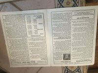
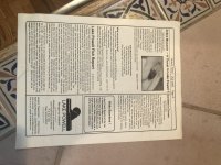
Somehow I have this copy of leisure times. Showing the first customer at Hite.
and back page has Wayne’s fish report
Lake level 3,641.94
Water temp 75
Somehow I have this copy of leisure times. Showing the first customer at Hite.
and back page has Wayne’s fish report
Attachments

broski
Well-Known Member
Cool find!! Interesting (and a reminder) that even all the way back in 2002, mussels were already a major topic and concern...and now look forward 19 years. Sad panda :-(July, 2002
Lake level 3,641.94
Water temp 75
Somehow I have this copy of leisure times. Showing the first customer at Hite.
and back page has Wayne’s fish report
Bill Sampson
Keeper of San Juan Secrets
JFRC, I need to ask you a question. I plan on being on the San Juan the second week of July. Usually I stay close to Great Bend. Historically, what water year would be the best to compare this year to? Thanks in advance.Here's an image of Halls Creek and Bullfrog taken 5-27-21... I can see how Halls looks more like a canyon now instead of a bay!
View attachment 13234
You might have to go back to 1969 to find a comparison for the current lake level. (3555-3560 and falling)
Add to that there has been only a tiny bit of runoff which was not the case in the 60s and 70s?
Add to that there has been only a tiny bit of runoff which was not the case in the 60s and 70s?
JFRCalifornia
Keeper of San Juan Secrets
There's no real comparable to this year. In May 1969, it was at 3560 but on the rise, peaking at 3581 in July. The other year to look at is 2005, when it hit a low of 3555 on April 8, then began a very steep rise. It was at 3560 on April 26 and peaked at 3608 on July 12. (I guess the most comparable time would be from Feb-April 2005, when the lake dropped from 3560 to 3555.)
This year we're on a slow decline from 3560 in early July...that's unprecedented.
But to your point, here's an image from sentinel-hub.com taken on 6-26-21 of the Great Bend. Doesn't look too promising...

This year we're on a slow decline from 3560 in early July...that's unprecedented.
But to your point, here's an image from sentinel-hub.com taken on 6-26-21 of the Great Bend. Doesn't look too promising...
Last edited:
Bill Sampson
Keeper of San Juan Secrets
You are right about that. Thanks for forwarding this.There's no real comparable to this year. In May 1969, it was at 3560 but on the rise, peaking at 3581 in July. The other year to look at is 2005, when it hit a low of 3555 on April 8, then began a very steep rise. It was at 3560 on April 26 and peaked at 3608 on July 12.
This year we're on a slow decline from 3560...that's unprecedented.
But to your point, here's an image from sentinel-hub.com taken on 6-26-21 of the Great Bend. Doesn't look too promising...
View attachment 13802
Bill Sampson
Keeper of San Juan Secrets
John, or anyone following this thread, can you hazard a guess as to how far up the San Juan houseboating would be safe? My group usually water skis, wakeboards, and on occasion air chairs.There's no real comparable to this year. In May 1969, it was at 3560 but on the rise, peaking at 3581 in July. The other year to look at is 2005, when it hit a low of 3555 on April 8, then began a very steep rise. It was at 3560 on April 26 and peaked at 3608 on July 12. (I guess the most comparable time would be from Feb-April 2005, when the lake dropped from 3560 to 3555.)
This year we're on a slow decline from 3560 in early July...that's unprecedented.
But to your point, here's an image from sentinel-hub.com taken on 6-26-21 of the Great Bend. Doesn't look too promising...
View attachment 13802
JFRCalifornia
Keeper of San Juan Secrets
That's a hard question to answer for sure since I haven't been there recently, but I can make an educated guess. The San Juan is a silt machine, and just as in the north end of the lake, most of the silt drops where the river meets the lake and spreads slightly downstream. I guess the good news is the the lake hasn't been quite this low since 2005, so there hasn't been loads of past deposition far downstream of where the lake ends now. Some of course, but the unexpected sandbar problem really gets bad when the lake repeatedly goes up and down over the same place (as near White Canyon). In the Great Bend, it has gone up and down a lot over the past few years (early spring 2019 was almost like today), but not really downstream of there. So I wouldn't expect unusual lake-fluctuation navigation hazards from say Piute Canyon and down. You're probably good all the way to Neskahi Wash, but again, I haven't been there recently. Others might know better. It would be great to know the silt deposition profile on the San Juan.John, or anyone following this thread, can you hazard a guess as to how far up the San Juan houseboating would be safe? My group usually water skis, wakeboards, and on occasion air chairs.
I can say that historically, the 1953 Lake Canyon quad shows the pre-lake base elevation at the top of the Great Bend to be about 3490. And in June 2015, when the lake was at 3591, it ended right at the top of the Great Bend. So that suggests about 100 feet of silt deposits there. At the location where the lake ends now (per the 6-26-21 aerial) near the beginning of the Great Bend, the historic base elevation was about 3460 or so. That again implies 100 feet of silt there.
The 1953 USGS No Mans Mesa quad shows that before Lake Powell, the base elevation at the mouth of Neskahi Wash was roughly 3440. So as long as less than 100 feet of silt has built up there since, you're still okay--but the water would only be about 15-20 feet deep at most. But who knows what bars and hazards lurk in Piute Bay.
The safe play is to go no farther than Piute Canyon... but hopefully others have realtime experience that's better than my guesses...
Bill Sampson
Keeper of San Juan Secrets
John, thanks for your observations. Puite Canyon has good possibilities. Based on other threads, the normal anchorages I use are all high and dry, so I will find new ones. Thanks again, and I will file a report when I return
Crash12rm
Member
I am curious where you got the satellite view. I have not been able to find any satellite view that is up to date with current water levels.Here's an image of Halls Creek and Bullfrog taken 5-27-21... I can see how Halls looks more like a canyon now instead of a bay!
View attachment 13234
JFRCalifornia
Keeper of San Juan Secrets
Go to this site:I am curious where you got the satellite view. I have not been able to find any satellite view that is up to date with current water levels.
Open the "Sentinel Playground" and you can get low res realtime imagery from just about anywhere...
Crash12rm
Member
Thank youGo to this site:
Open the "Sentinel Playground" and you can get low res realtime imagery from just about anywhere...
Meatwagon
Keeper of San Juan Secrets
Thanks for the link. I wonder if it is possible to get a sticky or a short cut to find this link to make it easier for others to find it. It seems like this question about up-to-date images comes up alot. Bartsplace??Go to this site:
Open the "Sentinel Playground" and you can get low res realtime imagery from just about anywhere...
- Status
- Not open for further replies.