Glen Canyon National "Recreation" Area

Status
Not open for further replies.
I've spoken with Superintendent Michelle Kerns about Blue Notch specifically. She was very professional and accommodating. She's the one who alerted me (us) to the public comment period that was approaching last year. Blue Notch, in my opinion, is the fallout of a larger issue stemming from a lawsuit by SUWA in which the verdict/settlement was for NPS to create a much more detailed (rigid, in my view) management plan for off-road travel. I'm not aware of any "infractions" what were taking place at that location, but it got caught up in the plan nonetheless.

She did tell me that travel to the shoreline at/near Blue Notch is permissible for loading/unloading. However, vehicles must return to the end of the improved road (where the sign is posted) during your stay. I'm not defending it nor am I in favor of it, but that's what she passed along.

There is a new version of the management plan that was announced (released?) within the last few weeks. I haven't had time to find it and study it out for changes yet.

EDIT: found it -
Glen Canyon National Recreation Area implements new regulations for off-road vehicle use - Glen Canyon National Recreation Area (U.S. National Park Service)

Official Docs & Background -
Thank you for the information.

Did the sign state what you've indicated about access, or is it like the secret menu at IN and OUT BURGERS? I know there is a picture here somewhere.

The Plan now is the elimination of lake side shore camping with a land based vehicle. Seems you can still park your houseboat, and the like, and shore camp. If some can boat and camp, some should be able to drive and camp. Hard to find a difference here from a conservation aspect, wave action verse two tracks on the "improved road". I say this had me laughing for a minute. Besides, the original intent was to enjoy the land also. How long will it be before GHB is a sand pile like White Canyon, Farley's, Hite, ..... Let us enjoy it now before it is gone too, for fishing. Could be a great ATV place in near future.

It would be nice to know what the fee, or fine, would be to camp next to the lake with a vehicle. It might be worth it to some.
 
Fair question. By resources I don’t necessarily mean “NPS resources.” Every rescue —even a 3rd party—takes somebody’s time and money, plus gas, and commits that effort to rescuing you when others might need help at the same time…

Resources come in many flavors…
Agree it takes someone’s time and money. But government has no role in deciding how I spend my money. Or how Matt or Rabbit Brush recovery spends their time. Especially the feds whose role is strictly limited by what is written in the constitution.
 
Fair question. By resources I don’t necessarily mean “NPS resources.” Every rescue —even a 3rd party—takes somebody’s time and money, plus gas, and commits that effort to rescuing you when others might need help at the same time…

Resources come in many flavors…
Its not terribly different than many of the areas you frequent. Limiting use because of what might happen would greatly shrink the lake for someone like yourself. Climbing around in the rocks is dangerous at times. I hoped we wouldnt come to a time where "what if" had the force to become law.
 
How would a fishing place be destroyed by an ATV?
The new roads created across and down hills also creates sediment rivers that dump into lakes...that's how. So, some of my favorite natural lakes are silting in from man-caused roads. Now, I never said that is an issue at Powell. At Powell and specifically Blue Notch, I can look at Google Earth and see all of the roads that are made by OHVs and ATVs that are scarring the landscape. This abuse may not be hurting Powell but it definitely is hurting the area around the lake.
 
The new roads created across and down hills also creates sediment rivers that dump into lakes...that's how. So, some of my favorite natural lakes are silting in from man-caused roads. Now, I never said that is an issue at Powell. At Powell and specifically Blue Notch, I can look at Google Earth and see all of the roads that are made by OHVs and ATVs that are scarring the landscape. This abuse may not be hurting Powell but it definitely is hurting the area around the lake.
I would sure like to see an example of this that has actually happened. It's hard for me to imagine a situation where an ATV trail is making a significant difference in the amount of sediment that dumps in to a lake. Especially to the point that it is "destroying" a fishing place.
 
I would sure like to see an example of this that has actually happened. It's hard for me to imagine a situation where an ATV trail is making a significant difference in the amount of sediment that dumps in to a lake. Especially to the point that it is "destroying" a fishing place.
It's very true that when you're talking about a huge lake like Powell, fed by the greatest silt machine on the planet in the Colorado River, the relative erosion/deposition caused by vehicles is really small. Back of the napkin: there's been roughly about 2.7 maf of volume displaced by sediment since 1963 in Lake Powell. That's roughly equivalent to 4.3 BILLION cubic yards of dirt. Assuming the average dump truck holds 10 cubic yards, that's 430 million fully loaded dump trucks of dirt. The busiest freeway in LA carries about 350,000 vehicles per day. It would take about 3-4 years of heavy traffic on that freeway to generate 430 million trips. A few vehicles on Blue Notch do not compare.

So yes, when you compare the erosive/depositional power of a river to vehicles on the Lake Powell access roads, there is no comparison.

But if you're focused on a very small area, such as the feeder drainages to Good Hope Bay, vehicles can make a localized difference, especially in the areas above the lake surface. We can argue issues like the importance of shoreline stability, effects on habitat, etc., but when given a choice between causing erosion and minimizing it, and it's not that hard to avoid doing it by sticking to the roads, then...why not?

At the same time, I will also say that the unstable lake shoreline between its current level up to about 3650 has been fully raked over by the lake itself so often that any single vehicle's contribution to this dynamic is pretty minimal in the big picture. But if the lake remains low, again, why exacerbate an existing problem?
 
Priority for anything (cultural artifacts, flora, fauna, etc) existing below full pool was given up in the 1960's when the lake was created. I don't understand why we're returning to try to "save" that area now. Isn't that the same reason that campfires are allowed below high water mark and not above? I'm not advocating for a free-for-all, but I see no reason that responsible recreation at the shoreline (at any level) should be prohibited - especially when such recreation is expressly permitted when you arrive by boat.
 
It's very true that when you're talking about a huge lake like Powell, fed by the greatest silt machine on the planet in the Colorado River, the relative erosion/deposition caused by vehicles is really small. Back of the napkin: there's been roughly about 2.7 maf of volume displaced by sediment since 1963 in Lake Powell. That's roughly equivalent to 4.3 BILLION cubic yards of dirt. Assuming the average dump truck holds 10 cubic yards, that's 430 million fully loaded dump trucks of dirt. The busiest freeway in LA carries about 350,000 vehicles per day. It would take about 3-4 years of heavy traffic on that freeway to generate 430 million trips. A few vehicles on Blue Notch do not compare.

So yes, when you compare the erosive/depositional power of a river to vehicles on the Lake Powell access roads, there is no comparison.

But if you're focused on a very small area, such as the feeder drainages to Good Hope Bay, vehicles can make a localized difference, especially in the areas above the lake surface. We can argue issues like the importance of shoreline stability, effects on habitat, etc., but when given a choice between causing erosion and minimizing it, and it's not that hard to avoid doing it by sticking to the roads, then...why not?

At the same time, I will also say that the unstable lake shoreline between its current level up to about 3650 has been fully raked over by the lake itself so often that any single vehicle's contribution to this dynamic is pretty minimal in the big picture. But if the lake remains low, again, why exacerbate an existing problem?
The comparison made was to wave action. Are vehicles or boats a bigger problem for erosion? Thanks for the analysis, it was already clear the river is the real problem. It destroyed Hite, Farley's, White Canyon.... GHB is not far down on the list of who's next.

Exacerbate an existing problem? I'm confused? Most of the roads in this area were for mining and exploration, done for the benefit of the whole world. The uranium that was used to end WW II was mined from this area of the country and it was the government that pushed and supported this effort. Anyway, this is going to be a sand pile, slightly radioactive, so what are we saving by closing the area and what problem are we trying to solve, people having fun and enjoyment in a recreation area that was intended for this purpose?

Can we get the dump trucks rolling, I understand the Grand Canyon needs some sand. They can make a haul road from Hite to Page and provide more access to the lake. The Navajo's have already talked about a road to Navajo Mt. from the Halls area. Maybe we can get a road to Rainbow Bridge also while we're at it.

Or, how about we make the lake a no wake zone North of Bullfrog/Halls Crossing and open up a maintained primitive boat launch at the Blue Notch/GHB. I'm sure many would support this effort or a version of it.

Sounds a little extreme, similar to some others, but much better than closing the whole area off to those that actually use it.
 
Like Bart already said, the focus here is on what is below high waterline. The " roads" that some are stirred up about are nothing more than little 2- tracks thru the tammies and weeds. The reality is very much different than the what ifs and maybes that are being presented here. I would like to know how many have actually driven the road in there and seen it first hand.
 
Just because I don’t want to feel left out ;)

I would consider myself leaning to the “road closures” side much more than not. I love places you have to hike to. With that said… you still need access for people to realistically be able to enjoy it. This goes with lots of places around the country.

I absolutely HATE seeing any kind of off-road activity. It makes my blood boil as I’m always ok foot when I see it. But in this case, I don’t care if the area below the high water mark looked like a dirt bike track complete with jumps and the likes. It’ll be washed away at some point and we’ll never be the wiser. Some common sense should really go a long way here. An access road or two down to the lake and some signage about how much it’s going to cost them if they need to call Dave at rabbitbrush to come get them if they get stuck.
 
All good stuff but GCNRA aka Powell is a confusing place! Ask casual visitors and I'll bet that most would tell you it's a National Park and why not; Rangers are running around with their trademark hats and lots of stunning scenery everywhere you look. In these pages I see the words National Park and Glen Canyon National Recreation Area used almost interchangeably in places and I don't think that is correct in any way. If you think you feel restricted right now thank the stars above that Lake Powell isn't designated a National Park because if it were we'd have substantially less liberty there. (just saying, love the National Parks System but it's a whole other level of protection)

Same goes for "Wilderness" designation, I read those words too. If GCNRA were ever designated a "Wilderness area" the first thing to go would probably be powered vehicles including boats. Here outside of Flagstaff we have The Peaks Wilderness area designated by congress and signed into law by President Regan in 1984. It's inside of our Coconino National Forrest already and there are lots of additional restrictions to the Wilderness Area that go way beyond; It even goes beyond Wildlife Sanctuary designation as far as protections go, like no motorized vehicles, camping restrictions etc.

All the terms at Powell can kinda get amalgamated and confusing. I'm thankful that the R in GCNRA stands for Recreation because it sure is fun! However I completely recognize after spending a couple of years of my life there there (the best ones) that before it was a reservoir and GCNRA that it certainly could have been a National Park because of its uniqueness and beauty. In my opinion everyone who uses the lake a lot, every Powell enthusiast has to come to terms with that in their own way. For me I have kind of a reverence for that notion and I think it's possible to at least appreciate both sides of that situation without being a radical or to be slurred as a Drainer. (I'm not advocating that)

Like JFR says, those outdated managing documents represent some pretty broad interests; They are competing priorities at least.

I liked this post, good discussions. That why I like WW more than anything I can find on FB, you guys are great!
 
Last edited:
The closure at Blue Notch is for 330 acres that is below 3670'. So its already in the lake. Driving to the waterline here is no more a disturbance than say digging in an anchor. No sediment added or lost. No lasting impact. There are roads and trails above the 3670' closure that are part of a different discussion. I think that is where some of the confusion is coming from. OHVs on the BLM is a whole different can of worms, and should stay that way. My input here is about the lake and access to it.
 
Blue Notch and Farleys and White Canyon are definitely collateral damage from the SUWA lawsuit. Has nothing to do with resource protection. Just a way for the lawsuit to be settled and SUWA to claim a victory to their donors. As others have said these new rules will have zero practical effect because the people camping at the shoreline and the people creating new trails above the high water mark(a real problem) are two totally separate populations.
If people “legally” can drive their boats down to the waterline and unload then park uphill at the sign that’s big news! I can definitely say the signs did not say anything about being able to drive past for any reason. My hope was the park service would be lax on enforcement since the rules were thrust upon them by lawyers. Maybe they will. I was thinking we were all hoping that was the case but no one wanted to be the test subject after what happened in the recapture canyon protest ride.

As for ATVs ruining other lakes. Sure, there is silt damage. But in my experience cows and sheep cause way more damage. They gather around water sources and creeks and eat everything soft and green and trample every shoreline into mud. People will make trails around the shoreline. Cows and sheep will eat down to the bare ground. I’ve personally also seen this at Lake Mead. There are SxS trails here and there causing damage, sure. But meanwhile thousands of donkeys denude the countryside of every living thing. One or two rangers with rifles could do a lot more resource protection than a dozen writing SxS tickets. Every donkey shot is 20+lbs/day of vegetation saved for the price of a 50 cent bullet. That’s what I call “wise stewardship.”
 
Last edited:
If people “legally” can drive their boats down to the waterline and unload then park uphill at the sign that’s big news!

Yes - and it's now part of the new (January 13) document. It's wordy and slightly convoluted. Here are a few excerpts -

This part establishes the focus areas and execution of the new rules:
One change affects the following 10 shoreline access areas that are identified in table 1 to paragraph (f)(3)(ii) of the existing special regulations: Lone Rock Beach, Blue Notch, Bullfrog North and South, Crosby Canyon, Dirty Devil, Farley Canyon, Hite Boat Ramp, Red Canyon, Stanton Creek, White Canyon. The rule separates the existing shoreline access area at Bullfrog North and South into two shoreline access areas, one for Bullfrog North and another for Bullfrog South. The rule requires the superintendent to identify lake elevation levels at each of the 11 shoreline access areas where, if the lake elevation drops below the identified level and remains below the identified level for seven consecutive days, the shoreline access area will close to off-road motor vehicle use. Inversely, if the lake elevation increases above the identified level and remains above the identified level for seven consecutive days, the shoreline access area will open to off-road vehicle use.​

This part seems to confirm what the Superintendent told me would be the likely outcome last year (bold mine) -
A second change related to shoreline access areas adds a statement in the regulations that off-road vehicle use in any of those areas, including the shoreline access areas identified in table 1 to paragraph (f)(3)(ii) of the existing special regulations that are not subject to closure based upon lake elevation, must be for the purpose of traveling from a GMP road to the shoreline, and back. This draws a clear distinction between the purpose of off-road vehicle use in shoreline access areas and the purpose of off-road vehicle use in Lone Rock Beach, Lone Rock Beach Play Area, and Ferry Swale, which are identified in table 1 to paragraph (f)(3)(ii), but not considered shoreline access areas.​

That last one is reiterated as a note to the table of management areas in the master document:
(iv) Off-road motor vehicle use in any of the areas designated in table 1 to paragraph (f)(3)(ii), except for Lone Rock Beach, Lone Rock Beach Play Area and Ferry Swale, must be for the purpose of traveling from a GMP road to the shoreline, and back.​

I'm pleased that we're not cut off completely. A compromise is better than nothing, but I still disagree with the basic premise of a closure in the northern lake. As it currently stands, there is no where to "truck camp" north of Stanton Creek.

Also! I noticed that you can comment on these new (final?) rules until February 12!

If you feel so inclined, the document is located here -
https://www.federalregister.gov/doc...anyon-national-recreation-area-motor-vehicles

There is a big green button "View Comment Instructions" on the top right of the document. This does not appear to be something you can do online, but instead you must mail any comments to the address listed. I'll likely send them some of my own comments from this thread.
 
Last edited:
Yes - and it's now part of the new (January 13) document. It's wordy and slightly convoluted. Here are a few excerpts -

This part establishes the focus areas and execution of the new rules:
One change affects the following 10 shoreline access areas that are identified in table 1 to paragraph (f)(3)(ii) of the existing special regulations: Lone Rock Beach, Blue Notch, Bullfrog North and South, Crosby Canyon, Dirty Devil, Farley Canyon, Hite Boat Ramp, Red Canyon, Stanton Creek, White Canyon. The rule separates the existing shoreline access area at Bullfrog North and South into two shoreline access areas, one for Bullfrog North and another for Bullfrog South. The rule requires the superintendent to identify lake elevation levels at each of the 11 shoreline access areas where, if the lake elevation drops below the identified level and remains below the identified level for seven consecutive days, the shoreline access area will close to off-road motor vehicle use. Inversely, if the lake elevation increases above the identified level and remains above the identified level for seven consecutive days, the shoreline access area will open to off-road vehicle use.​

This part seems to confirm what the Superintendent told me would be the likely outcome last year (bold mine) -
A second change related to shoreline access areas adds a statement in the regulations that off-road vehicle use in any of those areas, including the shoreline access areas identified in table 1 to paragraph (f)(3)(ii) of the existing special regulations that are not subject to closure based upon lake elevation, must be for the purpose of traveling from a GMP road to the shoreline, and back. This draws a clear distinction between the purpose of off-road vehicle use in shoreline access areas and the purpose of off-road vehicle use in Lone Rock Beach, Lone Rock Beach Play Area, and Ferry Swale, which are identified in table 1 to paragraph (f)(3)(ii), but not considered shoreline access areas.​

That last one is reiterated as a note to the table of management areas in the master document:
(iv) Off-road motor vehicle use in any of the areas designated in table 1 to paragraph (f)(3)(ii), except for Lone Rock Beach, Lone Rock Beach Play Area and Ferry Swale, must be for the purpose of traveling from a GMP road to the shoreline, and back.​

I'm pleased that we're not cut off completely. A compromise is better than nothing, but I still disagree with the basic premise of a closure in the northern lake. As it currently stands, there is no where to "truck camp" north of Stanton Creek.

Also! I noticed that you can comment on these new (final?) rules until February 12!

If you feel so inclined, the document is located here -
https://www.federalregister.gov/doc...anyon-national-recreation-area-motor-vehicles

There is a big green button "View Comment Instructions" on the top right of the document. This does not appear to be something you can do online, but instead you must mail any comments to the address listed. I'll likely send them some of my own comments from this thread.
Thank you for the information and could we get a better reaction with a petition, or grouped signed letter? In reality, they seem to only respond to lawsuits. The information only mentions "off-road motor vehicles". Can we still drive a normal vehicle on the dirt roads in this area? They supersede the creation of the recreation area and should be grandfathered in.

In another document I see that snowmobiles and motorized wheelchairs are not off-road vehicles so you could shore camp with them.

I find the NPS's efforts to control erosion quite comical because this is the cause of most of the parks, monuments, and recreation area of the southwest. If the NPS was around many years ago, would not have same scenery we do now, like the Grand Canyon, Arches, Monument Valley, Rainbow Bridge and Lake Powell to name a few.

So, based on this, the issue is not about controlling erosion, it's about controlling us, the public, from enjoying public lands. And in general, this is not what the intent for the GCNRA was based on what I've seen. It would be great for someone with the time and recourses, and maybe a legal background, to look at the history of the GCNRA and see if its original intent is still being promoted. I feel the intent was changed by some in authority, without the actual authority to do so. Conservation is a good thing, but when a small group of people, do not like what is being done, we all suffer from it when those in authority choose to appease them.
 
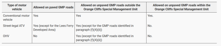
The information only mentions "off-road motor vehicles".

Somewhere buried in that set of documents they explain that, yes, regular vehicles may travel off-road for the stated purpose. Basically when they say "off-road vehicle use" they are talking about any allowed off-road capable vehicle. When they are addressing a specific type of vehicle, they will use the designations "ATV" or "OHV" respectively. Again, the language isn't clear, but this table shows what I'm talking about -

1737867878095.png
 
...
But if you're focused on a very small area, such as the feeder drainages to Good Hope Bay, vehicles can make a localized difference, especially in the areas above the lake surface. We can argue issues like the importance of shoreline stability, effects on habitat, etc., but when given a choice between causing erosion and minimizing it, and it's not that hard to avoid doing it by sticking to the roads, then...why not?
...

there is this idea by some people that they aren't truly recreating unless they are driving some machine "into the wilds". the problem in specific out west is that many of those areas do not do well when disturbed by wheeled or tracked machines. if people were instead walking or riding a horse, etc. the damage would not be so bad, but still once enough people walk the same path it becomes damaged and noticeable and the more arid the climate is the more time it takes to return to "normal".

any ecologist understands how fragile a western arid landscape is - your average person who has the eastern mindset (where green stuff and rains are more frequent) transplanted to the west doesn't often understand this. your average person from the city also is likely to not really understand it either.

some posters in this thread keep asking about damage and saying they don't see it, but the repeated replies about using google maps or your other favorite sattelite pictues viewing platform will easily show how much damage is being done and that damage will be there and visible for quite a long time (as exhibited by hundred year old tracks from various previous migrations across the arid landscapes).
 
Status
Not open for further replies.
Back
Top