powellglass
Active Member
Love that peek A Boo arch hike!

Love that peek A Boo arch hike!

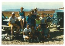
What a great photo of you Wayne! I have a few photos from the hike in the bowl looking out at that amazing view in 2009. If I locate any guide for me in posting pictures here would be helpful too. My daughter has a few pics from houseboat trip this year and our anchorage near Great Bend in neskahi bayPeek-A-Boo is one of my favorite hikes on Lake Powell. View attachment 16341
Long ago I was on 2 houseboat trips from the San Juan Marina. After launching we saw a river runner coming in from upper San Juan into the bay where marina was located.Searching the digital archives of the Cline, U of U, Ft. Lewis, etc. I've never seen a photo of any of the old river runner at Peek-a-Boo. I've often wondered if it is because of the difficulty in accessing the bench from the San Juan River. If anybody sees a pre-Lake Powell photo of the arch, please post.
Do you have any pictures of the San Juan Marina? Two years ago I visited the old site. You can search WW and see the photos. There is a decent book about it, also. It's called Floating Hogans by Wanda Ellits.Long ago I was on 2 houseboat trips from the San Juan Marina. After launching we saw a river runner coming in from upper San Juan into the bay where marina was located.


Yes I do. I also have a short video clip of our group launching on the ramp. How do I upload photos. I will take a screenshot of photos and upload.Do you have any pictures of the San Juan Marina? Two years ago I visited the old site. You can search WW and see the photos. There is a decent book about it, also. It's called Floating Hogans by Wanda Ellits.
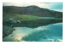
From outside the San Juan Marina store area looking down at the houseboat docks. My Toyota van was new and the washboard road gave it some memorable creaks! This is my first picture posting so doing my best, sorry about the double post. Any help welcome!
With gratitude! I've been working on this for awhile!Great job!
I've never seen any pre-lake photo of Peek-a-Boo arches either... but I have found an old oblique aerial from 1958 that shows where the landing site would have had to be to make the hike, and from this, I'd guess it would have taken a real effort to figure out how to get up the bench there...one that few if any would make. Compare the 1958 aerial and the 2013 Google Earth image I created of how to access that hike...Searching the digital archives of the Cline, U of U, Ft. Lewis, etc. I've never seen a photo of any of the old river runner at Peek-a-Boo. I've often wondered if it is because of the difficulty in accessing the bench from the San Juan River. If anybody sees a pre-Lake Powell photo of the arch, please post.


I have done this hike twice. starting at a much higher water level. It is am amazing hike.I've never seen any pre-lake photo of Peek-a-Boo arches either... but I have found an old oblique aerial from 1958 that shows where the landing site would have had to be to make the hike, and from this, I'd guess it would have taken a real effort to figure out how to get up the bench there...one that few if any would make. Compare the 1958 aerial and the 2013 Google Earth image I created of how to access that hike...
View attachment 16376View attachment 16377