Castle Rock Cut Filling - 2023

Status
Not open for further replies.
SPOILER ALERT !!!!!!!!!!!!!!!!

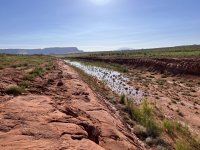
I walked the whole Cut this morning and found some interesting data. As near as I can tell, the Castle Rock Cut is NOT filling much at all . It is not moving much from the Warm Creek side or the Wahweap side. The CUT today looked just like it did on my last hike all the way across. My hike today was 1 mile from Wahweap to Warm Creek which is the same as the last hike. The pictures of the water in the Cut that I thought was filling from the Warm Creek side was actually a big rain water pool from the big storm last Friday. Today, as far as I can tell the water is not moving much in the Cut!
These are photos taken today!

View attachment 23643

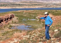
Compare this to the previous photo while standing here.

View attachment 23644

I think the lake moved a tiny bit higher. Maybe it is 50 yards closer but certainly not much different from the photo taken today.

So what is happening? It seems to me that the lake level rise has declined from a foot per day to much less over the weekend. I hope the lake has not quit coming up and this was just a weekend pause. But, right now the lake still has to go across this flat one mile before joining with water in Wahweap. Here are some more pictures taken today.


View attachment 23645

I have a Doctor appointment in St George on Wednesday and will not be back until Thursday. I can look at the Cut again on Friday and see what has changed. Hopefully there will be a whole bunch of deep water in the Cut by the weekend.
If I remember there were two small dams to keep the water out when they were finishing, the water washed that area flat and the water should have to go over a slight humps on each end then should fill quickly.
 
Broski stopped at my place in Evergreen and picked up another (i think) 90 Merc for that boat right after Petester gave it to BB. I never heard if or what happened after that. Sq
I think it was blown up on the very FIRST run they had it! I'm glad they re-powered it too. That would be AWESOME to see Tail-Dragger be the first boat through the cut! I wave to Pete & Patty every trip as I pass Gregory :love:
 
Friday June 23rd. Walked the Cut from water to water. The distance between the Wahweap and Warm Creek water is still 1/2 mile!!!
That is hard to believe. Obviously the raising water is slowing down.

Here is the Warm Creek side.

IMG_3418 2.jpeg

And the Wahweap side.


IMG_3424.jpeg

The distance needed before the two waters join is 1/2 mile. I am not sure when or if this is going to happen. As I drove to the lake this morning it looked like the outflow from Glen Canyon dam has increased? I am not sure about that, so I will just keep watching and see if the waters join and allow the Cut to fill enough for boats to use the short cut. Only time will tell.

We also ran into this little guy while hiking back to the boat.


IMG_3428.jpeg
 
Last edited:
Thanks for the report, and for the photos, Wayne. The rise of the lake is slowing down rapidly, and I don't hold out much hope that it will reach a depth where boats can travel its length. It would be great, but I don't think so. Also, my prediction of 3610' is looking real bad, so somebody else is going to win the trophy. . . and thanks to BZeg!!
 
That is true but the distance between the water on both sides is now 1/2 mile instead of 1 mile. If the lake fills up to 3590 the Cut could work? I am just not sure when, since the inflow is starting to lag behind.
The elevation difference of 3 ft shortened the distance by half a mile (3576 per your post on 6/17). I would imagine we should be seeing both ends touch in the next 6 -7 days.... hopefully
 
The obvious issue is the bottom of the cut is no longer at 3580’.

th
 
The lake is still rising a 6" per day, sure, 40k CFS isn't 70k, but it's nothing to scoff at. 6" is an absolute ton of water for such a big lake, and considering blue mesa is 7' from running over, and the snowpack is still high, it's going to come up at least for 2-3 more weeks. If it averages 1/3 of a foot for 21 days, that's almost 6 feet. . .

There are two real issues here:

1. Putting 17k cfs into Lake Mead daily during the summer is a bit of a waste. BOR should drop that to 12-14k, and consider the impact of not being able to use the cut to the boater. They could do it at 12k for longer and allow Mead and Powell to rise while considering the boater at the same time. But then again, is the Bureau of "Reclamation" not Recreation.

2. Whether you believe in climate change or not, May melted the snow this year and caused a weird run off season. When May outperforms June, trouble is on the horizon.
 
Kinda weird the last couple years water rises then like a light switch slows down. Last year barely came up actually lowest rise I’ve seen in year and this year record snowfall and already tapering off?
2011 was great but water was rising into august first week it finally peaked

Another topic but I’m thinking numbers are fudged a lil bit. But most are thrown off because is it was a good year no doubt but still feel something’s up.
 
but still feel something’s up
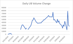
Something is "up", and it's the upper basin reservoirs. On around March 6 they bottomed out at 5.38 million Acre-Ft(mAF) or 58.6% full. Today they are at 9.07 mAF or 87.8% a difference of 3.69 mAF. The average daily fill rate of the upper basin reservoirs has been 31,225 AF per day. I plotted the daily volume change below and we see a downward trend since around the first of June(an outlier showed up a few days ago).
1687555827236.png
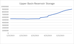
Considering the upper basin as a single reservoir we see a pretty consistent volume increase since early March. Overall storage continues to climb, but based on the daily change data above you can almost see the slope of the curve change around the first of June in the graph below.
1687556043261.png
Bottom line, it's been a good year for Powell, and an excellent year for Upper Basin Reservoirs.
 
Something is "up", and it's the upper basin reservoirs. On around March 6 they bottomed out at 5.38 million Acre-Ft(mAF) or 58.6% full. Today they are at 9.07 mAF or 87.8% a difference of 3.69 mAF. The average daily fill rate of the upper basin reservoirs has been 31,225 AF per day. I plotted the daily volume change below and we see a downward trend since around the first of June(an outlier showed up a few days ago).
View attachment 23743
Considering the upper basin as a single reservoir we see a pretty consistent volume increase since early March. Overall storage continues to climb, but based on the daily change data above you can almost see the slope of the curve change around the first of June in the graph below.
View attachment 23744
Bottom line, it's been a good year for Powell, and an excellent year for Upper Basin Reservoirs.
We all knew they were going to catch them up first, since they released more last year to benefit Powell. The Gorge has recovered quite nicely, and it is by far the biggest upstream reservoir. It will continue to have lot of water coming in as well with all the rain that has been keeping flows high the Green River. It is still flowing strong, and Fontenelle is full for all intents and purposes.

Now we have to hope we get the "Good" El Nino year to really recharge the system!
 
On an observational note....we've never had the ability to observe anything like this in 'real time' before...

Thank you WW & Wayne!!

We wordlings can literally be there....& be a part of it......without 'being there'.

Amazing, and again we so appreciate it & all the updates!

On another note, did you send the snake back to Washington D.C. where it belongs?

Sorry, that wasn't fair to the snake.......

:cool:
 
When all the water talk was going on, no body really thought of the BOR doubling the outflow. They were setting back laughing.
Powell would of came up over 80 ft if not. And so many of our states reservoir's are full, if a guy is not happy with that, oh well. But having water on every ramp but Hite, is pretty darn good. Whether you believe in climate change or not😊
 
Status
Not open for further replies.
Back
Top