
You are using an out of date browser. It may not display this or other websites correctly.
You should upgrade or use an alternative browser.
You should upgrade or use an alternative browser.
Wahweap Marina Island?
- Thread starter Ed_on_WD
- Start date
- Status
- Not open for further replies.

Rivergoer
Keeper of San Juan Secrets
Latest pics from “KAI” (K and I) dock, as a local called it. Wahweap Island is approx 5-6’ high. At least one, possibly two houseboats currently locked in by the island but they appear winterized so no immediate issue.
If the entire Marina can be moved 30-40 feet offshore, the island would be centered where I dock formerly resided leaving everyone able to freely come and go. That would however further squeeze the navigable no wake channel east of the Marina.
12/2/21 Elev 3541


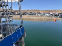
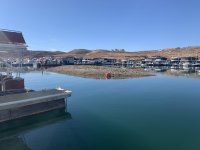
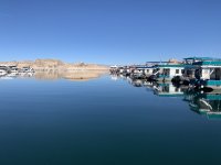
If the entire Marina can be moved 30-40 feet offshore, the island would be centered where I dock formerly resided leaving everyone able to freely come and go. That would however further squeeze the navigable no wake channel east of the Marina.
12/2/21 Elev 3541


dallas massie
Escalante-Class Member
This might seem stupid , but cant they get a backhoe on a barge and just start digging . Instead of having to move the whole marina.

Maverick5207
Escalante-Class Member
I have a houseboat on i-dock and I'm currently on my boat. These pictures are current.
Also, I met one of the boat owners that is blocked in. He and his wife were staying on the boat for a few days. He told me that the marina told him that if he wanted to take his boat out, they would take the dock apart if that's what needed done to give him access to the lake.
I'm on the dock they moved and I now have the best view in the marina. Ha
Also, I met one of the boat owners that is blocked in. He and his wife were staying on the boat for a few days. He told me that the marina told him that if he wanted to take his boat out, they would take the dock apart if that's what needed done to give him access to the lake.
I'm on the dock they moved and I now have the best view in the marina. Ha
Attachments


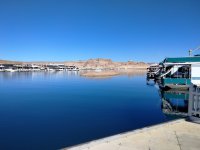
And before you had the best hump in the marina. Glad it was you. Thanks for the pics. How deep was the hump when fish started holding there?I now have the best view in the marina. Ha

Rainbowbridge
Keeper of San Juan Secrets
I'd guess they'd have to dig down underwater about 10', then a foot a month till spring runoff. But what happens when they hit solid rock?This might seem stupid , but cant they get a backhoe on a barge and just start digging . Instead of having to move the whole marina.
In a James Bond movie, they'd use TNT.......those houseboats would then be 'shaken AND stirred'

It IS solid rock, if Navajo Sandstone can be called solid. It’s the top of a promontory or a knob on a fin that projects out from the west side of the canyon. There are a couple of others lurking directly east of the marina and more along both sides of the bay (Canyon) as you proceed downstream towards the dam.
Rainbowbridge
Keeper of San Juan Secrets
I remember in one of the old pics of the ramp...'65 maybe, there were other whales a jumpin'
Gonna be interesting thru April-ish.....sigh.....
Gonna be interesting thru April-ish.....sigh.....
It might be more cost-effective to dig that island out rather than try to relocate the marina. The other option for the marina is the middle of Wahweap Bay between the high water Stateline Ramp and the Gustaveson Ramp. The excavated dirt could be dumped in the inlet / cove over to the east / northeast. (There are probably all kinds of constraints having to do with sediment retention, navigable waterways, and so forth, but this is just my amateur suggestion.) Since the knob is still there while the terrain around it eroded away, it's probably a little harder than the stuff around it, but water saturated sandstone didn't seem to be too much of a problem with the Castle Rock Cut. The marina slips would still need to be changed to a more rectangular configuration than the current square configuration.
Since the knob is an island down to 3,450' or so, it would require barging the excavated material. If it were all on the surface and easily accessible the crew from the Bingham Canyon Mine could have that cleaned out in a day or two.
Dark grey on the rendering is the minimum power pool at 3,490' elevation, and blue is the minimum reserve pool at 3,370' elevation.
Big thank you to dallas massie for a "stupid suggestion" that really deserves to be investigated further.
Since the knob is an island down to 3,450' or so, it would require barging the excavated material. If it were all on the surface and easily accessible the crew from the Bingham Canyon Mine could have that cleaned out in a day or two.
Dark grey on the rendering is the minimum power pool at 3,490' elevation, and blue is the minimum reserve pool at 3,370' elevation.
Big thank you to dallas massie for a "stupid suggestion" that really deserves to be investigated further.
Attachments


JFRCalifornia
Keeper of San Juan Secrets
Well, its sometimes possible to get creative on the environmental impact study part of the equation if you think like an attorney. It might be possible to issue a Categorical Exclusion (with some supporting documentation why that was appropriate) if you do a little regulatory gymnastics. The 2015 NPS NEPA Handbook lists a whole bunch of potential exclusions for all kinds of actions, and while most obviously don't apply, here's one that might qualify:It would probably require a dredging permit, which is a whole ordeal, including environmental impact study, sediment testing, etc.
Section 3.3
C.19. Construction or rehabilitation in previously disturbed or developed areas, required to meet health or safety regulations, or to meet requirements for making facilities accessible for the handicapped.
Not a perfect fit, but close enough--seems to me this action would be all about access, health and safety. The area is previously disturbed and developed because it's sitting in a reservoir.
If I'm NPS's consultant, that's where I'd start (and finish) the environmental review process.
It's also worth noting that if this is considered an "emergency" under NEPA (a questionable assertion I'll admit), you can defer the NEPA process until after the action is completed....
The key question in considering what is the appropriate level of review in any NEPA process is this: "Who is the opposition and will they sue you, with the potential to delay the process or cost unacceptable amounts of money to defend the process?"
Rainbowbridge
Keeper of San Juan Secrets
Great contour pic and overlay...ThX!
JFRCalifornia
Keeper of San Juan Secrets
This is a screenshot from a video someone posted on another thread a couple of months ago showing the early days of Wahweap Marina, likely early 1965, when the lake was at 3491. Is that "Wahweap Island"? Here's a link to that video and discussion:
 wayneswords.net

Historic video of Wahweap Marina
This video shows the early days after the completion of Glen Canyon Dam. This would be the "legacy ramp" at the Marina.
John P Funk
Escalante-Class Member
It's not a stupid question, but it's unlikely that the hill is only gravel/dirt. If it were, I suspect they would have removed it already. More likely it's slickrock with a layer of gravel on top. In addition as the lake recedes further, more and more material would need moved/removed.This might seem stupid , but cant they get a backhoe on a barge and just start digging . Instead of having to move the whole marina.
..... and the photo confirms my assertion.
PS: Note to self, read the rest of the posts before responding. Good answers everyone.

Thank you for the alternate viewpoint. We can complain about cumbersome permitting processes, how long it takes to get anything done, but it's good to have a reminder that we as a society have decided to consider the side effects of our actions.Prime fish habitat, these features should not be removed.
That picture is 50 feet lower than now. They can't let the lake go down that far. Even with 20 feet of buffer (lake level down to 3510) the strong sucking force of the water being drawn into those intake heads would create huge vortexes which could inject air into the turbines and damage them. I think 3520 (30 feet of buffer) might be lowest they can go without having to slow down the turbines, which would lower electricity output (or raise the price to ration it). If you want to rain down divine wrath, start messing with air conditioning in Phoenix and Vegas. In that scenario, access at Bullfrog becomes small potatoes.
So with 5 months to go (December, January, February, March, and April) before spring runoff starts, we have 20 feet to play with, and we can squeak past 3520. Then we'll pass the baton to the 2022 spring runoff and say our prayers that it's a healthy one. Otherwise, we'll be at this same place (or worse) a year from now, wringing our hands again.
So with 5 months to go (December, January, February, March, and April) before spring runoff starts, we have 20 feet to play with, and we can squeak past 3520. Then we'll pass the baton to the 2022 spring runoff and say our prayers that it's a healthy one. Otherwise, we'll be at this same place (or worse) a year from now, wringing our hands again.
- Status
- Not open for further replies.