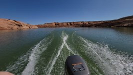
Videos from trip May trip North end

Status
Not open for further replies.
As a note for lower water levels in the Escalante, the rock that you went to the west of around 2:50 - 3:00 will be a peninsula at lower water, and you will need to follow the original river channel to the east.
 
Great videos! Thanks for posting. Definitely want to try to get out on the Lake sometime in the next year or so. About how long did it take to get down to 50 mile?
 
Sparkin5280, why would you sell the BEST mode of transport to see Powell?!! Especially that wave-smasher 300X/LX
with the heaviest hull being constructed of fiberglass with 22 degree of deadrise?? I have done 60+ trips to Powell and
all except maybe 15 have been via PWC. And the other trips in my Yammie LS2000 jet boat, an overgrown pwc. With that
Kawi you are only drafting 6 inches or so at speed. You get into the narrowest, tightest nooks and crannies where no boat
can go. You're gonna miss that Kawasaki mothership!!!:cry:
 
All right, by popular demand (LOL thats a stretch) here's the next installment. A shorter one taken right after I passed Slickrock ending with Rincon in sight. Then a longer one Rincon down to Bowns. Sorry for the finger over the lense occasionaly.
Great videos! Thanks for posting. Definitely want to try to get out on the Lake sometime in the next year or so. About how long did it take to get down to 50 mile?

I got from my camp and Halls Creek to the mouth of the Escalante in just under an hour. And then another 10 minutes to Fifty Mile. I was trying to be conservative with fuel so I was running about 35 miles an hour give or take. But on the way back was a pretty big storm and I had to slow way down because I was freezing and trying to prevent getting splashed constantly. Getting back took closer to 1.5 hours. A boat would have definitely made things a bit easier and more comfortable. And I have a couple of boats but I didn't know if I could launch them, hence bringing the smaller pwc.
 
Sparkin5280, why would you sell the BEST mode of transport to see Powell?!! Especially that wave-smasher 300X/LX
with the heaviest hull being constructed of fiberglass with 22 degree of deadrise?? I have done 60+ trips to Powell and
all except maybe 15 have been via PWC. And the other trips in my Yammie LS2000 jet boat, an overgrown pwc. With that
Kawi you are only drafting 6 inches or so at speed. You get into the narrowest, tightest nooks and crannies where no boat
can go. You're gonna miss that Kawasaki mothership!!!:cry:

Oh you're killing me, I know I kind of want to keep it! I buy and sell things and I bought this to fix and sell but it definitely exceeded my expectations! I used to be all about Sea-Doo but this Kawi is unbelievable the way it handled chop and cruised. On the way back I had to go most of the way with huge winds and waves I'm talking 3 maybe even 4 ft waves and I had to slow way down but this Kawasaki never let me down I truly think it may have saved me. I'm definitely a believer in it.

That being said my house boat trips have evolved more into Towing the friends-and-family behind the boat. I'm more of a water sports guy, I have a 22 ft Moomba craz, ski wakeboard surf fish boat. And then I have the Porta bote that can do some exploring, albeit much slower. So between the houseboat and worrying about the ski boat, having two more watercraft for my friends and family to beat up just adds more headaches than I feel like it's worth. I think if I had more opportunity to do these solo trips I would keep it but this was a kind of rare hall pass that I got away from the family.

You interested in this Beast? Pm me if so.
 
As a note for lower water levels in the Escalante, the rock that you went to the west of around 2:50 - 3:00 will be a peninsula at lower water, and you will need to follow the original river channel to the east.

Wow you mean that rock that started poking its way up last year will actually be a peninsula? It's right outside of the Cove we call 4 eyes. If I'm down there with the ski boat this year I'll have to graph the bottom and see what you're talkin about. Or let's just hope it doesn't get that low!
 
Wow you mean that rock that started poking its way up last year will actually be a peninsula? It's right outside of the Cove we call 4 eyes. If I'm down there with the ski boat this year I'll have to graph the bottom and see what you're talkin about. Or let's just hope it doesn't get that low!
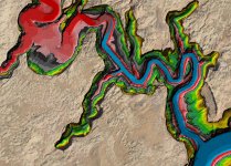
Here's my contour rendering of the start of the Escalante Arm up to Clear Creek Canyon. Greens, yellows, and browns are above water now. It looks like you are okay at least down to power pool, but don't cut that point too close.
 

Attachments

  • EscalanteArm.jpg
    EscalanteArm.jpg
    274.7 KB · Views: 38
I have more coming. Here is a long one I took leaving from the Bullfrog dirt launch at the old Main Ramp peninsula, quickly going to marina then blasting out of the Bullfrog Bay, into main channel then into Halls Creek. Again I didn't realize the GoPro cuts off right before 12 minutes, I actually rode all the way to the end of Halls, but it's not on here. It's long enough I guess LOL!

thanks for sharing, do you have any video of the end of halls?
 
thanks for sharing, do you have any video of the end of halls?

So the video I took from Bullfrog into Halls I actually rode the ski all the way back to the end of Halls but I didn't realize the camera shut off right at 12 minutes. I don't have GoPro video of the rest of Halls but I did take some pictures back there. It pretty much ends at these cottonwood trees poking up. With the size of these trees you think that the water was at least 20 ft deep here but it was actually 3 ft deep, soft mucky bottom. I think it's basically where the silt extends down into the creek/bay.

If you look on the Sentinel Hub playground towards the end of Halls Creek where the water goes from a medium green color to it chocolate milk color that's where I took these pictures. The "lake" continued on for another few hundred yards but at 3 ft deep I didn't feel like going any further.

20220502_095439.jpg

20220502_095504.jpg
 

Attachments

  • 20220502_094931.jpg
    20220502_094931.jpg
    343.3 KB · Views: 41
  • 20220502_100149.jpg
    20220502_100149.jpg
    502.2 KB · Views: 39
Ok back by popular demand (that's a stretch LOL, I can't belive some of you are watching these) I have 2 videos I took going down to Escalante that morning of May 3rd. First one is starting about Slickrock then rounding the bend to see Rincon. Then from Rincon and that long stretch down to about Bowns. I mistakenly narrated the second video saying it was April 3rd, but it was May 3rd. The rock cliffs just infront of Rincon making an appearance where striking.


What these videos confirm (happily) is that while the lake may be lower, there are still wide expanses of beautiful water with room for everyone. Higher walls, new beaches, and endless opportunities for skiing and sightseeing (and even fishing, for those who so choose). Given proper access, the lake is in great shape, and it’s a treasure for all who come to visit. Thanks for these armchair trips. What a service you provided for those of us who are home bound, braving those freezing 3 foot waves on your way back to Bullfrog. Thank you sir!
 
What these videos confirm (happily) is that while the lake may be lower, there are still wide expanses of beautiful water with room for everyone. Higher walls, new beaches, and endless opportunities for skiing and sightseeing (and even fishing, for those who so choose). Given proper access, the lake is in great shape, and it’s a treasure for all who come to visit. Thanks for these armchair trips. What a service you provided for those of us who are home bound, braving those freezing 3 foot waves on your way back to Bullfrog. Thank you sir!

Thanks for saying that! Yeah, I did really want to show people that there is still a ton water and places to see and go. With so much negativity lately surrounding the lake I though it was a good idea to share some fun experiences. But you are right, it did get nasty on the way back and I pushed my limits. Next day was dead flat calm, should have done it that day. Notice you won't see any videos on the way back because it was full on survival mode. If I had only figured a way to mount the GoPro on the cowl for some video of the way back, now THAT would be some footage worth watching! Got real bad around the Rincon on the way back and I almost went over to the floating restroom to duck for cover, but just pressed on. Oh and I did find time to fish when in Halls, and caught several stripers and even a walleye.

20220502_095201.jpg
 
Last edited:
Ok this is the last of my video series from the 1st week of May 2022. I took these the day before I rode to Escalante. Did a quick run up to Moki in the evening of May 2nd and was trying out the GoPro. I was still new to it and hit the stop record button halfway through the canyon so I started it back up again, hence part 1 and 2. I usually go south on our houseboat every year, but in May of 2020 we camped there for a brief stay when my family lauched the houseboat right as Covid shutdown was letting up. Water level then was right around 3590 or 3600 if I remember correctly. So seeing it at 3522 this time around was pretty striking. One of my other reasons going to Moki was that I was hearing reports of a mountain lion prowling the beaches up there. I didn't see the mountian lion but there were some kayakers in the canyon, I stopped to chat and they saw what they thought were large dog prints. I don't think it was a dog! Wish I could have seen that cat, but I didn't.


Thank you SO much for your vids!

We who aren't there.....(yet..... 🤞) ..........Live vicariously through you......and are a bit....ok, a lot, envious....

;)
Again, please keep 'em comin' :)

Thank you for saying that! I was like you guys with large expanses of not much useful information posted here over the winter so I thought I'd throw something interesting up on the site. Also my house boat launch is questionable with the water levels so this might be my only trip there this year, so I might have to go back and watch these myself LOL!

Those last two of Moki where pretty much the last ones I have. I do have another post coming with a bunch of depth readings in and around Bullfrog but no "exciting" videos.
 
So the video I took from Bullfrog into Halls I actually rode the ski all the way back to the end of Halls but I didn't realize the camera shut off right at 12 minutes. I don't have GoPro video of the rest of Halls but I did take some pictures back there. It pretty much ends at these cottonwood trees poking up. With the size of these trees you think that the water was at least 20 ft deep here but it was actually 3 ft deep, soft mucky bottom. I think it's basically where the silt extends down into the creek/bay.

If you look on the Sentinel Hub playground towards the end of Halls Creek where the water goes from a medium green color to it chocolate milk color that's where I took these pictures. The "lake" continued on for another few hundred yards but at 3 ft deep I didn't feel like going any further.

View attachment 18361

View attachment 18362
thanks so much!!
 
Status
Not open for further replies.
Back
Top