The Greatest Story Ever Told - the last days before the rise of Lake Powell

Status
Not open for further replies.
If you look very carefully on Google Maps / Earth at the Sand Hills bench area south of Alstrom Point and Romana Mesa between Warm Creek and Gunsight Canyons you can see the vestiges of a road. I've seen mention of a road to Kane Wash near Crossing of the Padres, but have not found any maps showing that pre-lake road. (The best old map that I have is a 1954 1:250,000 "Escalante" topo map covering a large portion of that area, long before Page, highways to Bullfrog, Lake Powell, and so forth.) There must have been some kind of road to bring in all of the equipment for Greatest Story Ever Told. My best guess is that it came down Crosby Canyon (current road), crossed Warm Creek, and then continued on the low bench level to the Kane Wash area. Any really old timers have any information about that, or the isolated road segment on the Sand Hills below Romana Mesa?
So I found the 1953 Gunsight Butte USGS 1:62500 quad, and its a great map showing the pre-dam river in the vicinity of where the movie was filmed, with the Crossing of the Fathers clearly marked at the mouth of Kane Wash. But nowhere is there a hint of a road that leads there, or to Alstrom Point for that matter. I've attached the quad.

But then I came across a great photo from the January 1964 Arizona Highways, which was dedicated entirely to promoting the brand new Lake Powell. I'll have to do a whole post on that magazine spread, which is even more impressive than the 1967 National Geographic because it's 48 pages of recording the first impressions of Lake Powell (plus Glen Canyon Dam and Page too), and most importantly captures dozens of photos of the lake from the summer of 1963, when the lake was just starting to fill, and probably still somewhere in the 3300-3370 range.

Anyway, I'm attaching one 1963 photo taken over Padre Canyon looking toward Padre Butte and beyond while the lake is just starting to fill, but the future Padre Bay has not yet become Padre Bay. Still looks like a river. (By the way, this photo gives you a good idea of what “Dead Pool” at Lake Powell would look like, since it’s taken somewhere close to 3370, which is dead pool.)

What is clear in the photo is the there is indeed a pretty good looking road winding along the bench above the river/lake, and that's undoubtedly the one used to access the movie set...and for that matter had to be the way in and out once they diverted boat traffic off the river at Kane Wash in the years just before the dam was completed. They must have built that road after the 1953/54 USGS maps, but it didn't last long: that road disappeared under the lake in pretty short order...
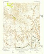
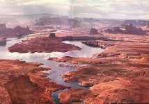
UT_Gunsight Butte_249675_1953_62500 - small.jpgSummer 1963 - Padre Canyon 3300-3370?.jpg
 
Last edited:
Old Friends that lived in Page before I arrived indicated that to launch a boat in Lake Powell in the early years, they had to drive a long dirt road into Padre Canyon. This was the closest launching area in the early days. It was beautiful back then, as it is now as well.
 
Very good JFR! I grew up in Kane County. My father, brother and I all worked at one time or another for movies being filmed there. There were many!! My father and brother worked on "The Greatest Story Ever Told". I've attached a photo from Christmas day, 1962. All the movie people from California had returned for the holidays and to let the snow melt so filming could resume.. My dad and brother would go out each day to feed and care for all the animals used on the set. The photo is my dad, Clyde, riding on one of the camels, also named Clyde. Turned out Clyde, the camel,, was a female and had a baby while on the set. The baby was named Utah.
Mom and I visited the set many times during filming. They had flame throwers to heat the rocks so the apostles could stand to walk on them barefoot. Much of the local sagebrush was spray painted to add color to the pictures. The Walls of Jerusalem were only a front, propped up in back by 2 x 4's and scaffolding. There was a whole road (chariot road that is) leading up to the walls with the "criminals" hanging on crosses. We could drive around the lake, past Lone Rock and further up in to Warm Creek.
We have a scrapbook that Mom put together about this film. I'll try to find it and post other information if you'd like.
View attachment 12759
I LOVE this!!1 What a fantastic and cherishable memory for sure!!! Please do share all you'd like!
 
Pure speculation on my part, but the road from Wahweap to Kane Wash might have been built/improved to allow boaters to pull out between Hite and Lees Ferry when the dam was under construction. I've seen mention of cattle rustlers using that general route and the Crossing of the Padres long before Lake Powell. (Wikipedia identifies that as part of the Armijo Route of the Old Spanish Trail.) I have a picture from 1962 at Hite with a sign reading:

"WARNING DANGER
Colorado River closed to boat traffic through construction zone Glen Canyon Dam 15 miles above Lees Ferry. No river exit facilities available between this point and Lees Ferry."

That wording implies no river take-out at Kane Wash, but JFRCalifornia's post shows an obvious road, and the Explore PDX Glen Canyon site has pictures of the takeout at Kane Wash, and also a gravel "ramp" at Halls Crossing at river level. The sign in the picture looked a bit faded in 1962.

It's interesting that the topo map labels "Alstrom Point" to the east of Gunsight Bay, while modern usage has Alstrom Point to the west of Gunsight Bay.
 
Last edited:
Pure speculation on my part, but the road from Wahweap to Kane Wash might have been built/improved to allow boaters to pull out between Hite and Lees Ferry when the dam was under construction. I've seen mention of cattle rustlers using that general route and the Crossing of the Padres long before Lake Powell. (Wikipedia identifies that as part of the Armijo Route of the Old Spanish Trail.) I have a picture from 1962 at Hite with a sign reading:

"WARNING DANGER
Colorado River closed to boat traffic through construction zone Glen Canyon Dam 15 miles above Lees Ferry. No river exit facilities available between this point and Lees Ferry."

That wording implies no river take-out at Kane Wash, but JFRCalifornia's post shows an obvious road, and the Explore PDX Glen Canyon site has pictures of the takeout at Kane Wash, and also a gravel "ramp" at Halls Crossing at river level. The sign in the picture looked a bit faded in 1962.

It's interesting that the topo map labels "Alstrom Point" to the east of Gunsight Bay, while modern usage has Alstrom Point to the west of Gunsight Bay.
I'm pretty sure you're right about the timing and purpose of the road to Kane Creek/Wash. What's clear is that from Katie Lee's river journals from 1954-57, it's only starting in 1956 that there was a sign at the mouth of Face Canyon warning all boaters they had to leave the river at Kane Creek, so the road would have been new and constructed because of the dam construction. From your 1962 photo, it seems that there was historically no road exit between Hite and Lees Ferry, but that by 1956, a road had been constructed to Kane Creek to allow (require) boaters to leave at that point. They just didn't remove (or change) the faded old sign at Hite, probably because so few people ever took to the river.

And yes, I also noticed the placement of Alstrom Point on that topo map, which is different than the place we know it today. On modern maps (National Geographic or even Kelsey's book), the point that the 1953 quad called "Alstrom Point" is now called "Little Alstrom Point", while the modern Alstrom Point west of Gunsight Bay is not labelled on the old topo map.
 
Last edited by a moderator:
Old Friends that lived in Page before I arrived indicated that to launch a boat in Lake Powell in the early years, they had to drive a long dirt road into Padre Canyon. This was the closest launching area in the early days. It was beautiful back then, as it is now as well.
I recently came across an extremely interesting document written in 1962 or very early 1963 called "The Outlook for Boating and Other Recreation in Glen Canyon National Recreation Area During 1963". The author is not listed, so I don't know who this was written by or for, but it is fascinating for many reasons. It's the only pre-Lake Powell document I've seen that actively predicts the mechanics of transforming the Colorado River into Lake Powell so close to the time it happened, and predicts/speculates with varying accuracy how it would play out in the near-term--that is, through 1963-64. Very clearly and simply written, the paper covers lots of topics, from boating, fishing, the rise of the lake, river dynamics, effects on existing canyon tours, lake access, and when various places along the river/lake would be inundated. For example, it goes into some detail about how and where you could launch a boat in the early days, including the role of the road to Kane Creek and Padre Canyon. And yes, it confirms what you say Wayne--you had to launch at Padre Canyon (referred to as "Navajo Canyon" on the 1953 USGS quad that covers the area) as the lake began to rise.

For those interested, I'm attaching the whole document (only 6 pages, worth reading the whole thing), but here's a few of the nuggets it contains:

1. The road to Kane Creek originated at Wahweap and was 25 miles long.

2. The short-term plan to launch boats in the early days of the lake was to do it from Padre Canyon via Kane Creek Road, until the road itself becgan to submerge under the lake, at which point you'd launch from the end of the road as it dipped underwater. (!)

3. After the road went under, launching would shift to Wahweap Creek (pre-marina), but launching there would only be possible once the lake rose 387 feet from baseline (or up to 3519). (Right there is a clue for the future operations at Wahweap...)

4. The original launch ramp at Wahweap was to be 1100 feet long (with a 500-foot gravel extension), and was to be 200 feet wide, at an 8.5% grade. The lowest edge of the permanent launch ramp at Wahweap would not be usable until the lake was 420 feet deep at the dam, or at elevation 3552. The paper speculates this level would be reached by the end of 1963, and "certainly by summer 1964". The paper got that wrong, as the lake didn't reach that level until May 1969! (And here we are again at that level today!) Drought is not a new phenomenon to the region--those years in the mid-1960s were (with the exception of 1965) well below average, and so those optimistic filling projections were way off base. In that sense, not much has changed. I doubt that many predicted in 1963 that it would take 17 years to reach full pool...

5. Canyon Tours, Inc. was the original concessionaire. That was Art Greene's outfit. Six other approved river guides are also listed.

6. Rafters leaving Hite in 1963 and unprepared to encounter Lake Powell were not warned they would eventually hit slack water, unless they somehow thought to call the Park Service in advance of their trip. (!)

7. The early emphasis of boating on Lake Powell was the trip to Rainbow Bridge, where it was assumed you could soon reach the narrows at Bridge Canyon then continue walking 1.7 miles to the Bridge. Bring your own gas and hope you don't encounter driftwood as the lake rose...

8. Fishing! They were planning to stock the new lake with 7 million trout and bass fingerlings in spring 1963. Below the dam, it was going to be larger catchable trout. The paper doesn't say how many.

9. No water skiing was to be allowed in 1963 because it was believed the lake wasn't wide enough to do that safely.

10. The NPS was planning marinas/facilities at Wahweap, Bullfrog, Halls Crossing, Hite, and... Hole-in-the-Rock (!)

Read the whole document. This is a valuable little slice into the first planning thoughts about recreation on the lake...

if it doesn’t load right, you can also grab it at:


Attachments

Last edited:
"The National Park Service has made plans to accomrnodate launching regardless of the elevation of the lake surface."
Therein lies the rub!
 
My neighbor 2 houses down survived. He is still disabled....lower right leg and foot. He can get around and even drive, but has endured severe physical pain all his life. A recent surgery has allowed him more mobility, but at age 72 he still has some PTSD. It was 58 years last month.
 
Since this thread is already hijacked (thank you JFR for all of your knowledge and research, your posts are always very interesting)…

Doesn’t this lend credence to my argument that there should be another launch ramp somewhere up lake? If not in Warm Creek then in Kane Creek?
 
Since this thread is already hijacked (thank you JFR for all of your knowledge and research, your posts are always very interesting)…

Doesn’t this lend credence to my argument that there should be another launch ramp somewhere up lake? If not in Warm Creek then in Kane Creek?
As long as all hostages are returned, I have no problem with hijacked threads... :)

Not sure Kane Creek would still work, not easily anyway. What made it possible in the pre-lake days was that you could build a road on the bench above the river across (or around) Wahweap Creek, Warm Creek, and Gunsight Creek without having to get way up on the mesa. But that bench is underwater now, so a road would now have to come from high above on the mesa, which is about 4400, then switchback down somehow to Kane Creek (or Padre Canyon) at let's call it 3600...

Warm Creek might work a little better...
 
Since my recent post about Planet of the Apes, it got me thinking about another slightly earlier movie that provides a completely different insight into Glen Canyon, in literally its last days before it transformed into Lake Powell.

The Greatest Story Ever Told was a classic 3-hour biblical epic, released in 1965. It was a pretty good story, but not really a great movie (my opinion), although it was beautifully shot, with gorgeous cinematography in a sort of Lawrence of Arabia kind of way. Originally, director George Stevens’ idea was to film it right there in Israel and Jordan, with the baptism scenes at the Jordan River, but once he took a look at the less-than-inspiring Jordan while scouting for possible locations in 1961, decided it just wasn’t dramatic enough for what he envisioned.

And that’s how they ended up filming those scenes at Glen Canyon. Now it was late 1962, and the Colorado River still flowed through the canyon, muddy and serene, a perfect setting against the red buttes and mesas. The problem the production crew faced was time—Glen Canyon Dam was scheduled for completion in early 1963, and they needed a river, not a lake, for the movie to work. And so they rushed to complete these scenes as the winter of 1962-63 took hold, finishing literally as the waters began to rise at the end of January 1963. What they captured on film between the faux Romans and Navajos posing as Bedouin shepherds was nothing less than the very last days of Glen Canyon as it had been known to that time.

In the attached stills from the movie, you can easily see Gunsight Butte, and the nearby sweeping turns of the Colorado River, in an area that would soon become Padre Bay. And there hip deep in the freezing water is no less than Charlton Heston as John the Baptist, hiding a wetsuit under his outfit to avoid shivering to death in the frigid Colorado River. It was only 5 years later he would be back to almost this exact same spot as one of the astronauts from Planet of the Apes, then paddling a raft on a lake that did not yet exist in 1962, depicting a future Earth alien enough to look unrecognizable to movie audiences of the late 1960s. And so it was in the winter of late 1962 that the same place could pass for the Holy Land of 2000 years ago, with the same actor in a very different role, with a very different setting, and yet the same dramatic backdrop.

If nothing else, the hidden legacy of The Greatest Story Ever Told is as a time capsule, a brief final look at a pre-Lake Powell Glen Canyon, literally days before the dam closed and the waters began to rise…

Here's a Dec 1962/Jan 1963 downstream view from the movie toward Gunsight Butte, with the mouth of Kane Creek Canyon doubling as a gathering spot for Charlton Heston as John the Baptist. This spot is very close to where Heston came ashore on Padre Bay with the other two astronauts in Planet of the Apes, filmed less than 5 years later...
View attachment 12674


Great pre-Lake Powell view along the Colorado River, Dec 1962/Jan 1963...
View attachment 12675

Perfect shot up along Gunsight Creek toward Gunsight Butte, in what would soon become Gunsight Bay, minus the Roman soldiers. Filmed in the winter of 1962/63.
View attachment 12676

Thanks to good sleuthing by drewsxmi (see subsequent post), this shot is not in Glen Canyon at all, but it's the Green River, and that's Turks Head in the middle... In the movie, they mixed this shot in with the ones from Glen Canyon. Thanks for the correction!
View attachment 12677

Charlton Heston as John the Baptist. He's probably scowling because he's freezing to death standing in the Colorado River in December 1962... Apparently he wore a wetsuit under the loin cloths...
View attachment 12678
Thanks for the info! Who knew, right?!
 
As long as all hostages are returned, I have no problem with hijacked threads... :)

Not sure Kane Creek would still work, not easily anyway. What made it possible in the pre-lake days was that you could build a road on the bench above the river across (or around) Wahweap Creek, Warm Creek, and Gunsight Creek without having to get way up on the mesa. But that bench is underwater now, so a road would now have to come from high above on the mesa, which is about 4400, then switchback down somehow to Kane Creek (or Padre Canyon) at let's call it 3600...

Warm Creek might work a little better...
Not sure what the official name of the road is, but you could use the road on the Warm Creek Bench from Big Water, which is well above the lake level (way up on the mesa as JFRCalifornia mentions), and continues to Grand Bench, where you could try to build a dugway down to the Friendship Cove area. There is fairly good terrain just west of Friendship Cove that might be suitable for a long ramp into the water. You would probably need to build a bridge across Little Valley Canyon (one of the branches of Last Chance Canyon) to get out onto Grand Bench (between Last Chance Bay and Rock Creek Bay). Warm Creek Bay has the problem of shallow water and pretty flat terrain. The road would require a lot of work to be able to accommodate large boat trailers. It would probably be cheaper just to extend the Stateline, Wahweap, and Halls Crossing ramps as lower water levels allowed.
 
Last edited:
So the 6 page govt doc posted by JFR (outlook for boating) at bottom of page 2 running into top of page 3 says Wahweap ramp has 500 foot gravel extension beyond pavement end. At 8% grade this should buy us 40 more feet of access below 3555. Am I missing something?
 
So the 6 page govt doc posted by JFR (outlook for boating) at bottom of page 2 running into top of page 3 says Wahweap ramp has 500 foot gravel extension beyond pavement end. At 8% grade this should buy us 40 more feet of access below 3555. Am I missing something?
I think you got that just about right, although I think that paper implies the bottom of the permanent ramp ends when the lake is 420 feet deep at the dam, which would mean 3561. So whether or not the permanent ramp has since been extended below 3561, the gravel ramp would end about 40 feet below 3561, or at 3521. I think.

That assumes the gravel ramp is still more or less intact. And the practical utility of that ramp for bigger boats also assumes that those boats could still get in and out of Wahweap Bay (no major obstacles near the mouth of the bay/creek) at very low lake levels...
 
Status
Not open for further replies.
Back
Top