A man called horse
Active Member
Looks like the market is down for house boats & up for skiffs


Thanks for re posting those great pics and pithy comments........Bill said he went 'ape' over them.....In case anybody wants a glimpse of what the near future might look like on Lake Powell, all you've got to do is watch the original Planet of the Apes. The lake scenes were filmed on 5-21-67, and that pretty much coincided with the low point of that year... 3502. Here's a link to a past thread with stills from that movie showing the lake. You'll notice the bathtub ring--that's because it had peaked as high as 3545 the previous summer...
I made a post a few years ago about original 1968 Planet of the Apes, but I recently learned something new that provides some insight and perspective we didn't have before. I was never certain exactly when the scenes at Lake Powell were filmed, but I suspected it had to have been in the summer of 1967. Turns out I was close, but just a little off: the filming actually took place on May 21, 1967. Now that date is significant for water geeks on this forum, because it almost perfectly coincides with the low water point for that year, and it was LOW--3502. In fact, this was the lowest the...
- JFRCalifornia
- Replies: 7
- Forum: Lake Powell Issues

 Your sleuthing the filming date of May '67....not '68 puts a whole new perspective on it..

The original dirt/gravel ramp where the Stateline Auxiliary Ramp is located should be useable down to about 3450 feet, according to the NPS on 8/12/2021. Then there is a steeper dropoff to about 3423, which is the flat bottom of Wahweap Bay.Thanks for re posting those great pics and pithy comments........Bill said he went 'ape' over them.....
You are so right...we still have a great lake @ 3502....
Question: At 3502, in the south, the only ramp usable was the one that now is VERY close to the docks.....is that accurate?
I'd bet somewhere there are pics of the rocket ship and camera gear being barged through Maytag....that had to be a fun scene to watch....
THAT I did not know....thx.....about 3423, which is the flat bottom of Wahweap Bay.
guess I just coulda looked at the depthfinder, tho....
That ramp by the docks "surfaced" as the water level was dropping, and was already paved. The Stateline Aux ramp was just graded dirt & gravel and needed to be concreted before it could be very useful.THAT I did not know....thx.....
Why do you suppose they used the ramp by the docks @ 3519? If memory serves, that was beyond inconvenient? But, as Mom always said....we shall see....

Not much.Does the talk of El Nino have any effect on this summer weather pattern?

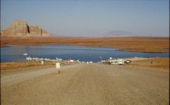
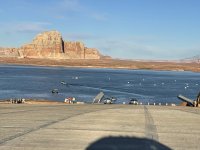
Regarding the main Wahweap ramp, I think the 500-foot extension is what currently shows at the end of the main ramp, and then the bottom drops away at a steeper angle, too steep for launching. The start of that slope might be exposed now.Here's a clue to what we might find at extremely low water in Wahweap. This photo was taken on 9-19-63, when the lake was at 3393. You can see they were already constructing Wahweap Marina, and there was already the beginning of at least some sort of rudimentary launch ramp...
View attachment 35153
And here's the other big clue to what to find at very low water. It's a passage that was written by the NPS in February 1964, when the lake was just over 3400. It seems clear from this that the NPS had once constructed temporary ramps that were usable down to that level (I presume it's what's shown in the photo), but they were always considered temporary. The permanent paved ramp they were building was intended to be usable down to about 3550, but a "500-foot extension" below that mark (gravel surfaced) was intended to deal with even lower water, which is more or less what we are facing now. The 8.5% grade of the ramp suggests the gravel ramp would be usable somewhere down to 3510-15 or so (someone check the math). I don't remember exactly what this actually looked like a few years ago when we reached 3519...
Here's the Feb 1964 NPS passage:
"The National Park Service has provided boat launching ramps to accommodate the visiting public at all stages of lake elevation. The ramps in use at the bottom of Wahweap Canyon will provide access during the formative days, are of a temporary nature, although designed to be safe and convenient. Such construction is practical since these ramps will soon be lost forever beneath the lake surface. They are both below the minimum pool storage level of the reservoir. When the surface of Lake Powell passes the 420 foot depth line at the dam, (it is at the 277 foot mark on February 1, 1964), its waves will be lapping at the lower edge of the permanent public launching ramp at Wahweap, and boating activities will center there. It is interesting to note that when this ramp comes into use, Lake Powell will be 170 feet deep in the middle of Wahweap Basin. The time the lake will reach this elevation is now unpredictable... This ramp has been designed and constructed to meet the modern demands of a heavily used marina. Its 1100 feet of asphalt surfaced pavement will extend well into the water at all normal lake elevations. A 500 foot extension at the lower end of the ramp has been constructed as an economical feature to continue launchings when the reservoir is at its very lowest permissible levels. The gravel surface of this lower prolongation is expected to be submerged except during rare periods in the life of the lake. The 200 foot width of the ramp will provide spacious room for the maneuvering of cars and boat trailers, and additionally, will be used as a parking area for the convenience of the boating public. Its 8.5% grade should permit easy launching of a boat from a trailer without the common annoyance of fully submerging the trailer (and often part of the towing car) as when on a flatter slope."

That has got to be one of the funniest pictures I’ve ever seen. Thanks John. SqHere's another very early piece of history about Wahweap. This photo was likely taken in June 1963, when the lake was somewhere in the neighborhood of 3340-3370 (depending on the date in June). This is the temporary launch ramp at Wahweap, such as it was at that time. This photo appears in the July 1963 issue of Desert magazine, and was part of the first ever published article about Lake Powell.
View attachment 35169
Maybe The first Lake Powell mutiny?Are they using a rifle to pull the boat in?
They’ve all got their life jackets on. That will protect them from the rifle!Are they using a rifle to pull the boat in?
I keep one on board to rescue swimmers......it's hilarious how fast they swim to shore when you start shooting.They’ve all got their life jackets on. That will protect them from the rifle!


Isn't his finger on the trigger too???Are they using a rifle to pull the boat in?
Aren't ours....many times?Isn't his finger on the trigger too???
Asking for a friend......