
You are using an out of date browser. It may not display this or other websites correctly.
You should upgrade or use an alternative browser.
You should upgrade or use an alternative browser.
Low water plans from NPS
- Thread starter Ryan
- Start date
- Status
- Not open for further replies.
Cross posting this to two relevant threads:
So sometime in the past few days NPS updated the minimum safe elevation for Bullfrog North to 3525' for all vessels (previously it was 3529'):
 www.nps.gov

This seems to better align with experience back when lake levels were that low. It is also the magic elevation that BoR claims it will try to maintain the lake at, though their current operational forecasts are for it to get a lot lower than that.
So sometime in the past few days NPS updated the minimum safe elevation for Bullfrog North to 3525' for all vessels (previously it was 3529'):
Changing Lake Levels - Glen Canyon National Recreation Area (U.S. National Park Service)
Changing lake levels
This seems to better align with experience back when lake levels were that low. It is also the magic elevation that BoR claims it will try to maintain the lake at, though their current operational forecasts are for it to get a lot lower than that.
Squirrel
Keeper of San Juan Secrets
Why in gods green earth would the NPS stop people from launching when everywhere there’s a launch ramp it says “Launch at Your Own Risk”. I’m hoping that we can chase the old road all the way down river bed at the primitive launch by the high and dry main ramp. SqDepends if NPS will allow it, that is big question as folks will drive around and try any spot to launch depending on vessel size..
kilojuliett
Active Member
Marina Bum,Thanks for posting Ryan, this is helpful. Sadly though none of the money from tiered boat passes was to go to dealing with lower water levels. The director said, when pressed in a meeting I sat in on almost two years ago that she was hoping to update the “Police Docks” with some of the revenue. (I opposed the fees, wrote a letter in during the comment phase, attended a meeting and wrote a long post about it at the time)
Their initial rational/justification for the increased fees at the time was that larger houseboats create more “erosion of the shoreline than smaller ones.” Also that they needed to make improvements to fuel docks and pump out stations to better accommodate the new super houseboats. Things like diesel fuel astride the fuel docks and reconfiguring or building larger berths at the pump out docks hence the “need” to charge them 10x more. The tiered money grab is looking like exactly what I expected, a tiered fee money grab. Apparently they think we have short memories and maybe they are right, we all seem to, new crisis, new day. In the end boating got more expensive for everyone and 75%of it is going to Washington DC where they know how to spend it best. (Sarcasm)
As per her pet project the “Police Docks” now located near Wahweap Ramp are in horrible condition and were built from left overs from the marina going back to at least the early 80’s. They should be replaced but we haven’t seen it yet. I hoped they would have used some of the money for that and that it would stay here and that they would shout about their achievement’s, about how they used some if it right here at Powell. (only a portion of the cash grab stays here, the rest goes into the PS General Fund, she said so in the meeting)
As far as erosion goes there is plenty to go around and I don’t see them doing much about that nor do I see any improvements to the potty or fuel docks. (Crap, I’d settle just to have every pump and hose reel even working, no trip hazards, cleats, the basics)
In the same meeting the director said that they’d been given a $160,000,000 grant to deal with the effects of lowering water levels. She also said that they were looking into spending 1/2 of that to realign and improve the ramp at Antelope.
OK then, wow? Isn’t there already a ramp 30 minutes away on the south end? One that has the capability of taking access down to 3450? Yes (State Line Auxiliary Ramp)
Question: So why then is it a priority to spend around $80,000,000 (the initial estimate) or 1/2 of the grant to chisel through solid rock on the South end when there is already a nearby option? (In Powell time, the lake is vast, everyone travels far to get here to begin with, 30 minutes is near by) It does not make a lot of sense especially when the North End is about to have nothing, no access. (I think I know why and maybe I’ll write about that later.)
In the meeting the director said they saw this happening, that her outlook was “ a return to a riparian environment within 5 years, actual dead pool, what comes in goes out.” I thought, well it’s her job to plan for the worst and I’m still hoping for the best, But why has it taken so long to act to keep access at both ends? And why for the love of Pete blow half the grant on a ramp that won’t end up very deep when there is another deeper one near by and why is it taking so long to get anything done? I think those are fair question.

I think your analysis is spot on. One thing that no one has mentioned is that Antelope Point Marina has the most expensive boats on the lake. From that I would think that all of these big money interests want to influence the budget decisions that NPS makes to their own advantage. I motor by the "Antelope Public Ramp" every time I go up lake in our houseboat (six times a year minimum.) I look at that ramp at current elevations levels and think it is ridiculous to spend that kind of money to make it work at current (or even lower) lake elevations levels. Antelope Point can no longer use their own "private ramp". They do not have the physical ramp pitch possibility to extend their own "private ramp" and probably do want to spend their own private money on it anyway. I would politely guess that the big money interests at Antelope Marina have been lobbying the NPS to spend public tax dollars to make the "Antelope Public Ramp" work for them. If anyone has been to Stateline ramp area recently you will see all the houseboats from Antelope Point Marina that are now stored in the Stateline upper parking so that they can do their routine out of water maintenance. The fact the Antelope Marina cannot haul out boats at their own ramp must really make the big money people at Antelope VERY unhappy. I am a south ender now but a Lake Powell lover. My first exposure (and first ten years) to the Lake was out of Bullfrog. NPS should drop any extension of the Antelope Public ramp and prioritize and spend that money on ramp access on the North End and continue concrete work on the Stateline Auxiliary ramp as water levels get lower.
My 2 cents, Kilojuliett
Why in gods green earth would the NPS stop people from launching when everywhere there’s a launch ramp it says “Launch at Your Own Risk”. I’m hoping that we can chase the old road all the way down river bed at the primitive launch by the high and dry main ramp. Sq
It says "Launch at Your Own Risk" for Non-motorized Vessels only. It clearly says "Closed" for all other vessels. And the "More Information" section usually has additional text doubling down on the fact they are closed to all motorized vessels.
It might come down to them wanting the ability to log what boats are going into the water for the muscle check process. I agree seems crazy they would not allow this, but just from prior comment.Why in gods green earth would the NPS stop people from launching when everywhere there’s a launch ramp it says “Launch at Your Own Risk”. I’m hoping that we can chase the old road all the way down river bed at the primitive launch by the high and dry main ramp. Sq
Slots-R-Us
Active Member
After the notification we were being moved I asked if they could tell me where the new location is. I received no reply. I have a little bit of appreciation for the situation and the task they are dealing with but wow! We have all paid significant fees and most of us have done it for many long years. There is no appreciation of that by Aramark (or I might add North Shore marina) it’s a shame the monopoly type position they command lets them fall into a pretty significant disregard for their customers. Who do we contact at Aramark to let our feelings be known?
Cheef Baconator
Active Member
I don't even want to imagine the cost of a crane that can reel in one of those big silly triple decker houseboats
darenstegelmeier
Active Member
Sending sympathies to all those that have lost their buoys and/or slips .. Happy to sign a petition to congressmen addressing this if someone wants to put it together ... I suppose that is the only way to get any action recourse on this decision.
Question for anyone in the know at Bullfrog. Is the NPS going to put in boiler plates for small boat launching between when the auxiliary ramp is out of water until we get the "Stanton Creek" ramp in place?
 www.nps.gov
when expanding the Bullfrog Launch Ramps here Project Updates - Glen Canyon National Recreation Area (U.S. National Park Service) you get this:

Question for anyone in the know at Bullfrog. Is the NPS going to put in boiler plates for small boat launching between when the auxiliary ramp is out of water until we get the "Stanton Creek" ramp in place?
Project Updates - Glen Canyon National Recreation Area (U.S. National Park Service)
Project Updates
when expanding the Bullfrog Launch Ramps here Project Updates - Glen Canyon National Recreation Area (U.S. National Park Service) you get this:
Question for anyone in the know at Bullfrog. Is the NPS going to put in boiler plates for small boat launching between when the auxiliary ramp is out of water until we get the "Stanton Creek" ramp in place?
Based solely on what they've done in the past, the answer is likely "yes." There have been no official announcements along those lines (that I'm aware of).
nzaugg
Keeper of San Juan Secrets
I am hopeful that there will be some kind of solution in place for allowing boats to launch, but what it will be is still a closely held NPS mystery. I am not optimistic about the Stanton prospects though, since the EA was supposed to be published 2/9/26 and the last published EA for the uptake area is from 2006.
darenstegelmeier
Active Member
I guess I made an assumption that they removed them when the water came back up. I suppose that would be hard to do, so they likely are there... It would be great if they are there, if someone notices that they are there, let the rest of us know.Aren’t the boiler plates already there? And maybe only a few vertical feet of new boiler plates able to be placed beyond the ones already there?
Dungee
Keeper of San Juan Secrets
It might come down to them wanting the ability to log what boats are going into the water for the muscle check process. I agree seems crazy they would not allow this, but just from prior comment.
There is ONE road into and out of Bullfrog, make a simple choke point check area right before the entrance station. You wouldn’t be missing any boats that had launched and or it would be unmanned just as well as any other check station is now. Easy solutions…
jeeps72
Active Member
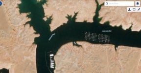
From 3/9, guessing they are getting serious about moving the Bullfrog marina. The old buoy field north of Halls has been removed and looks like any houseboat still on the water has been moved to the one remaining buoy field. Guessing again, that Bullfrog marina will soon be relocated north of Halls.
Attachments
A man called horse
Active Member
Just struck me that the only remaining north buoy field as adjacent to the ferry landing. Should we bet money on that as a saving grace?
Dungee
Keeper of San Juan Secrets
From 3/9, guessing they are getting serious about moving the Bullfrog marina. The old buoy field north of Halls has been removed and looks like any houseboat still on the water has been moved to the one remaining buoy field. Guessing again, that Bullfrog marina will soon be relocated north of Halls.
Yep, as we drove back down lake yesterday they had moved everything north from just a couple days before. Every buoy was taken and everything was neat. The emptiness of the more southern spot caught us off guard.
Mildog
Well-Known Member
Seems to me with no launching possible at bullfrog and no launch ramp at halls, doesn’t matter where they put the slips for boats you can’t get to them with out a boat unless you drive around to the slips at Halls but couldn’t have a fishing boat?? Now you are stranded at a slip paying fees and can’t get it pulled out of the lake!! I chose not to launch mine late last year for this potential outcome, I had approval for a slip at Halls but got nervous ! Sadly glad I didn’t launch!
- Status
- Not open for further replies.