I think the big problem still is going to be with difficulty seeing the water line and still shading the areas that are out of water as blue. Canyon ends will clearly be difficult as this will change based on siltation. Lake Genius has the most accurate bathymetry on the lake as its source data. If you wanted to do you own app with the same data it is out there and available, but even then there will be inaccuracies.
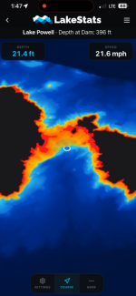
I’ve actually been building out a feature like this on my app LakeStats. I assume it uses the same bathymetric data that LakeGenius uses (a USGS survey from 2021). And I already am pulling the real-time lake level on LakeStats, so the map updates automatically.
It’s been accurate in mine and others testing, and the people testing report it being super helpful.
It’s still in beta, but if you have an iPhone and dm me I can send you the invite to join the beta version. I’d love to make this as helpful for other people as I can.
This site uses cookies to help personalise content, tailor your experience and to keep you logged in if you register.
By continuing to use this site, you are consenting to our use of cookies.