

JFRCalifornia
Keeper of San Juan Secrets
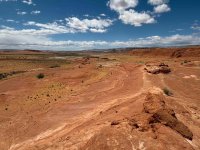
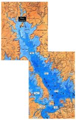
I don't have any aerial shots of what the Bullfrog area looked like at full pool from the angle in the 1962 photo, but it wouldn't be hard to add the shoreline. Suffice to say it covers most of the foreground. But here's a different perspective: this is a photo I took in May 2026 from a point far up Bullfrog Creek, about 5 miles upstream from the marina as the crow flies, facing more or less due south. You can reach this point with a short walk from a turnout along the lower end of the Burr Trail, just before it crosses Bullfrog Creek, which was at one time a good way to access the lake. Almost everything you see in this shot would have been underwater when the lake was full, and I would have been standing on a small island. In fact, I found a bunch of old boat artifacts laying around, including trash, discarded chairs, and old fire rings. On the attached map, I added a little annotation to show where I took the photo from...Any idea what full pool would have looked like in those old photos? How high up on those the ridges to the south and the flatter shallower grade to the north is 3700?
It’s been so long that I can’t remember. I just know in the 80’s and 90’s when I was much younger Bullfrog seemed massive to me.
Last edited:


