Thanks for the clarification

Heading down to Bullfrog Saturday... My boat is just an 18.5 foot runabout... Should hopefully still be okay for the upcoming week. Wish me luck!Thanks for the birds eye view. Very helpful. The shot of the Bullfrog South spur makes me wonder how long it will remain a viable option.
I launched a 18.5 solo at bullfrog last weekHeading down to Bullfrog Saturday... My boat is just an 18.5 foot runabout... Should hopefully still be okay for the upcoming week. Wish me luck!

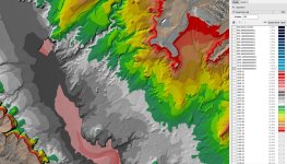
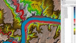
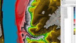
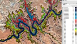
Here's a chart of the bathymetry around Bullfrog. The pink is approximately 3,490' with the third grey band in the 3,525' range. They have a good promontory with a steep slope into the water for the rental slips, but the whole bay starts getting too shallow somewhere around 3,500' elevation. The difficulty with the launch ramp is the shallow slope, although the spur is working well with launching off the side. I'll put up another image of the larger area in a few minutes.(Lake Powell: New ramp, new swim beach, and more)
This article implies a ramp at Bullfrog cannot go below 3,525' no matter how much money is thrown at it. That level will probably be reached around March, 2022. I do wonder what other alternatives are viable in, or around, Bullfrog Bay? If anyone has a link or information with regard to the bathymetry (i.e., sub-surface topography) for the Bullfrog Bay (including Hall's Marina on the south side of the 'river') it would be super-cool to, speculatively, wring one's hands over while drooling over the possibilities and dressed in a Dracula costume all at the same time, of course.
Lake Powell bathymetry data is at https://www.usgs.gov/core-science-s...ce_center_objects=0#qt-science_center_objects, then I use the Manifold Viewer Manifold Software - GIS, ETL, Data Science and Database Tools. Maybe if enough of us lobby Google we could get them to put that data set in Google Earth renderings instead of the lake surface.(Lake Powell: New ramp, new swim beach, and more)
This article implies a ramp at Bullfrog cannot go below 3,525' no matter how much money is thrown at it. That level will probably be reached around March, 2022. I do wonder what other alternatives are viable in, or around, Bullfrog Bay? If anyone has a link or information with regard to the bathymetry (i.e., sub-surface topography) for the Bullfrog Bay (including Hall's Marina on the south side of the 'river') it would be super-cool to, speculatively, wring one's hands over while drooling over the possibilities and dressed in a Dracula costume all at the same time, of course.
oh man this makes me very nervous. We are heading to Bullfrog Labor Day with our 24' v-hull and launch with our 40' DP motorhome. Can u please clarify if that "sweet spot" where the truck was launching is asphalt and if it is, how far does the asphalt go on that side? There is no way we can launch with a heavy motorhome in the dirt and like u said, the boilerplates look wayyyy too shallow to be able to get it off the trailer without drowning the coach.We just returned from Bullfrog and launching off the spur was no problem for our 24'. I wouldn't recommend the area between the cones on the boiler plate. You have to back too far out to make that work as can be seen in the aerial photo. The "sweet spot" is where you can see the truck launching/retrieving on the left with it's front tires still out of the water. Between the buoy to the left that boat and the boiler plat area is ideal. If you get too far to the left of the buoy it gets too flat and shallow. I saw a bunch of people backing in there and they couldn't get deep enough to float their boat.
When we were there two weeks ago, the "sweet spot" was asphalt into the water. I'm not sure how far out it goes. It is somewhat broken up in spots, but is still smooth and gives good traction getting into and out of the water. I felt like for us it was no more of a challenge putting in and taking out there than on the regular ramp. However I imaging everything is a little more challenging with a 40' motorhome. This isn't advice, but the conditions two weeks ago seemed like it would be possible to launce with a motorhome safely. Good luck!oh man this makes me very nervous. We are heading to Bullfrog Labor Day with our 24' v-hull and launch with our 40' DP motorhome. Can u please clarify if that "sweet spot" where the truck was launching is asphalt and if it is, how far does the asphalt go on that side? There is no way we can launch with a heavy motorhome in the dirt and like u said, the boilerplates look wayyyy too shallow to be able to get it off the trailer without drowning the coach.
OK cool ty very much.When we were there two weeks ago, the "sweet spot" was asphalt into the water. I'm not sure how far out it goes. It is somewhat broken up in spots, but is still smooth and gives good traction getting into and out of the water. I felt like for us it was no more of a challenge putting in and taking out there than on the regular ramp. However I imaging everything is a little more challenging with a 40' motorhome. This isn't advice, but the conditions two weeks ago seemed like it would be possible to launce with a motorhome safely. Good luck!