You are using an out of date browser. It may not display this or other websites correctly.
You should upgrade or use an alternative browser.
You should upgrade or use an alternative browser.
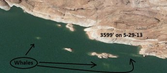
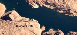
Watch out for the rocks toward the back of Navajo Canyon
- Thread starter Ken
- Start date
- Status
- Not open for further replies.
Littlesaltwash
Well-Known Member
I got the western lakemaster chip for fishing this spring. What a big time difference it makes with navigation. The $125 is worth every penny.
Basshound91
Active Member
Can you adjust lake levels with navionics map
Lake Powell gps Maps
Member
Those rocks catching our boat in Oak Creek Bay are what drove me to create "Lake Level Maps". Right now, I'd be using a "3600 Shallow Depth" giving you 9' of warning with the lake at 3609'.
If your interested take a look at the website: Oak Creek Bay Comparison These maps work on smartphones & tablets, laptops, Lowrance, and older Garmin units.
If your interested take a look at the website: Oak Creek Bay Comparison These maps work on smartphones & tablets, laptops, Lowrance, and older Garmin units.
Coho975
Well-Known Member
Short answer, No. You can set the shallow water highlight to whatever safety margin you feel comfortable with and add the current lake offset to that. It does not correct the contour lines, but it still somewhat useful.Can you adjust lake levels with navionics map
Littlesaltwash
Well-Known Member
I got the lakemaster after reading all the WW forum discussions re setting for lake level. I also wanted the future capability of using the I-pilot later when i upgrade the electric trolling motor. The map showed all of our routes dodging lower water levels. We stayed out one night late targeting walleyes and we just followed our route back to camp even though we couldn’t see anything but structure on the skyline.
Fursniper
Well-Known Member
So that's what whales are. I've always called them "sandstone torpedoes." When my prop gets dinged, I always blamed that on the hard water. 
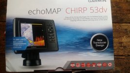
To avoid whales, sandstone torpedoes, and hard water, I recently installed a Garmin sonar unit that has topo maps, downscan imaging, and navigation capablilities for my bass boat. It came from the factory loaded with topo maps for inland waters. The Lake Powell topo map shows the lake bottom with contour lines at 10 foot intervals and allows shading different areas of depth. I have the bath tub ring shaded so the topo map coincides with the actual shoreline and a red zone for areas within 40 feet of the surface. Since everything within 40 feet of the surface is highlighted in red, I can see where potential obstacles are located ahead to avoid them. The red zone is also where fishing areas are located too. The unit updates my position 5 times/second when navigating.
When I navigate uplake about 40 miles, I do need to recalibrate the location of the shoreline and my red zone. It's quick and easy to adjust the shading of the different depth ranges if I need to. I have the deepest part of the main channel shaded dark blue so I can find the main channel without searching for the navigation buoys. It is way cool and no more taking a wrong turn.
Here is a picture of the unit. Cost is about $500.00 which is less than a prop for my boat. It has saved me a couple props already.


Last edited:
Gem Morris
Keeper of San Juan Secrets
When your prop hits that "hard water" what it leaves behind is propausaurus tracks 
Basshound91
Active Member
Are people really travelling that close to the shore. Why not travel middle of itsaw somebody else hit them again today
Ken
Active Member
They come out pretty far.. I'm talking about the last good open spot ('upstream' from the pics Goblin posted)Are people really travelling that close to the shore. Why not travel middle of it
Basshound91
Active Member
Can you Google map it
Ken
Active Member
Last edited:
Basshound91
Active Member
Holy crap. How far under the water are they
Basshound91
Active Member
How fast are these people going when they hit them.
The bad whales are just after the big sand dune. They are slightly closer to the sand dune side of the canyon so about a third of the way out in the travel lane on the right side heading upstream. Once past the dune there are some more hazards on the left side closer to shore. From here on just stay in the middle on the travel lane and you will be fine. The first map photos by Ken and Goblin show the rocks well.
- Status
- Not open for further replies.


