View from Trail Ridge Road

Status
Not open for further replies.
According to the local Fox News station Face Book feed it was today, and came from the NPS stating that road was finally open for travel.

Trail Ridge Road is in Rocky Mountain NP and runs across the Continental Divide between Estes Park and Granby.
 
And I thouht there was a lot of snow left in the Park City area! That's an insane amount. How great for Powell.
I don't know which side of the continental divide this picture was taken on...but remember the East side drainage does NOT get to Lake Powell. At any rate it is a lot of snow for sure!
 
I don't know which side of the continental divide this picture was taken on...but remember the East side drainage does NOT get to Lake Powell. At any rate it is a lot of snow for sure!


It sounds like the big snow is on the East side so likely the Eastern drainage - though isn't the headwaters for the Colorado in Rocky Mountain National Park?

ROCKY MOUNTAIN NATIONAL PARK, Colo. — Trail Ridge Road through Rocky Mountain National Park opened for the season Wednesday, but because of melting snow, visitors should expect icy conditions.

Park staff are still clearing snow from some areas and expect to open the Alpine Visitor Center and Trail Ridge Store later this week.

Since weather conditions in the park can change rapidly, officials encourage visitors to call the Trail Ridge Road recorded phone line at 970-586-1222 for updates.

Trail Ridge Road is the highest continuous paved road in the U.S. and historically opens on Memorial Day weekend.

But on May 18 and May 19, a major snowstorm hit the east side of the park, dropping more than 3 feet of snow in lower elevations.


Plow operators faced 8 to 14 feet of snow at higher elevations, hampering efforts to open the road by the holiday weekend.
 
https://www.nps.gov/romo/planyourvisit/trail_ridge_road.htm

Trail Ridge Road
TrailRidgeRoad_Banner_688x250.jpg

NPS


Trail_Ridge_Road.jpg

Trail Ridge Road, Rocky Mountain National Park's heavily traveled highway to the sky, inspired awe before the first motorist ever traveled it. "It is hard to describe what a sensation this new road is going to make," predicted Horace Albright, director of the National Park Service, in 1931 during the road's construction. "You will have the whole sweep of the Rockies before you in all directions."

The next year, Rocky Mountain National Park's lofty wilderness interior was introduced to the first travelers along an auto route the Rocky Mountain News called a "scenic wonder road of the world."

Was all this just enthusiastic exaggeration? Hardly.

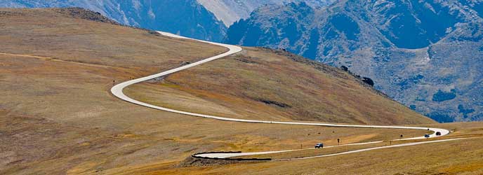
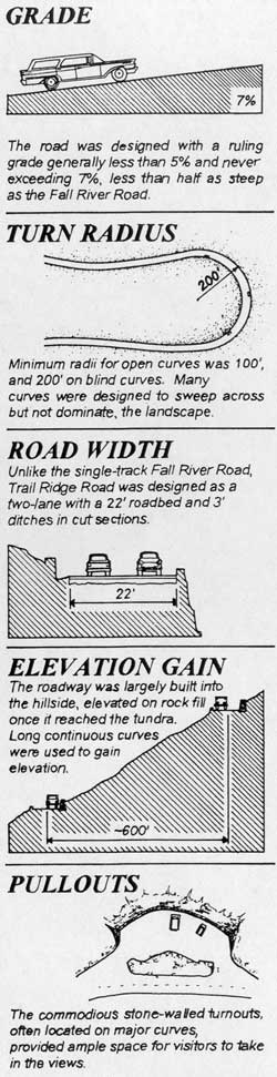
Covering the 48 miles between Estes Park on the park's east side and Grand Lake on the west, Trail Ridge Road more than lives up to its advanced billing. Eleven miles of this high highway travel above treeline, the elevation near 11,500 feet where the park's evergreen forests come to a halt. As it winds across the tundra's vastness to its high point at 12,183 feet elevation, Trail Ridge Road (U.S. 34) offers visitors thrilling views, wildlife sightings and spectacular alpine wildflower exhibitions, all from the comfort of their car.


Whether they begin their journey at Estes Park or Grand Lake, Trail Ridge Road travelers climb some 4,000 feet in a matter of minutes. The changes that occur en route are fascinating to observe. A drive that may begin in montane forests of aspen and ponderosa pine soon enters thick subalpine forests of fir and spruce. At treeline, the last stunted, wind-battered trees yield to the alpine tundra.


Up on that windswept alpine world, conditions resemble those found in the Canadian or Alaskan Arctic. It's normally windy and 20 to 30 degrees colder than Estes Park or Grand Lake. The sun beats down with high- ultraviolet intensity. The vistas, best enjoyed from one of several marked road pullovers, are extravagant, sweeping north to Wyoming, east across the Front Range cities and Great Plains, south and west into the heart of the Rockies.

But for all its harshness, the Trail Ridge tundra is a place of vibrant life and vivid colors. Pikas, marmots, ptarmigans and bighorn sheep are commonly seen. About 200 species of tiny alpine plants hug the ground. Despite a growing season that may last just 40 days, many bloom exuberantly, adorning the green summer tundra with swatches of yellow, red, pink, blue, purple and white. All are seen from the Tundra World Nature Trail, a half-hour walk beginning near the parking area at Rock Cut.

Most Trail Ridge Road travelers drive to treeline with a certain amount of urgency. They are advised not to ignore all that awaits in the verdant country below the alpine tundra. Forested moraines, great heaps of earth and rock debris left behind by melting Ice Age glaciers, rise above lush mountain meadows. The Continental Divide, where streamflows are separated east from west, is crossed at Milner Pass, located at a surprisingly low 10,758 feet elevation. Moose munch greenery in the upper reaches of the Colorado River, which flows through the scenic Kawuneeche Valley. Grazing elk greet sunrise and sunset in many of the forest-rimmed meadows found around the park.

At all elevations, the drive on Trail Ridge Road is a memorable adventure. Put aside at least a half day for the trip. Longer, if possible. The experience, as Horace Albright suggested more than a half century ago, is hard to describe.

Trail Ridge Road is one of ten America's Byways in Colorado and a national designated All American Road. Like to see as many byways as you can? On the outskirts of Rocky is the oldest Colorado Scenic Byway, Peak to Peak, and another America's Byway, the Colorado River Headwaters. To learn more about other Colorado Scenic Byways click here.
 
I don't know which side of the continental divide this picture was taken on...but remember the East side drainage does NOT get to Lake Powell. At any rate it is a lot of snow for sure!
Having been over Trail Ridge quite a few times I would say that more than 5o% off what you see there is going into the Colorado. What is impressive to me is the amount of snow on the peaks in the background. And it is a safe bet that most of that snow is going to the Colorado.
 
Having been over Trail Ridge quite a few times I would say that more than 5o% off what you see there is going into the Colorado. What is impressive to me is the amount of snow on the peaks in the background. And it is a safe bet that most of that snow is going to the Colorado.
I agree Randy, the West Side of the Continental Divide is "upslope", so it definitely gets more snow during normal weather situations. We still have significantly more snow than normal in the High Country of SW Colorado as well. The last week has certainly warmed up, and I suspect the Colorado runoff will be responding shortly.(Fingers Crossed)
 
I think I need to see that! I have a problem with heights sometimes. Did not have a problem with Going to the Sun Road in Glacier. Should I do east to west, or west to east?
 
I love it both ways. It has a different feel in each direction. I suppose you could do it in both directions in one day if you started early and avoided weekends. In that case I would drive east to west first so your not fighting the sun glare in early morning and late afternoon.

We have also driven the Going to the Sun Road in Glacier. They have similar characteristics, but Trail Ridge gives you a little more of the being on top of everything feel, while the Going to the Sun Road has the gorgeous views with the two lakes.

To be honest, I felt more uncomfortable driving parts of the highway from Boulder (Utah) to Escalante than I did on either of these roads. I am sure you would do fine.


~LOL~ the drive on the Escalante to Boulder road is interesting... my husband was afraid of heights - made him very uncomfortable.. but it is very pretty looking down and seeing Boulder sitting down there.......... we stopped at a Chevron Station there for gas and asked the best route to Halls Crossing [George had always gone to Wahweap prior to this late 70's trip]..... this old guy literally chewing on a piece of hay says oh you need to take the Burr Trail... "you might have to cog it down a bit, but it's the best way." All I can say is we wondered how many unsuspecting people he sent on that route - because we were barely out of Bullfrog before it was a washboard road, then before we knew it surrounded by the high cliffs and George explains to me this is a example of what to expect at Lake Powell [he had already been many times, I'd never been].... and then we get to a dry river bed with high red sand lining the bed on either side... - oh and we were driving my Monte Carlo - not a 4-wheel drive - so he backs up, guns it and like Dukes of Hazard the car literally jumps the river bed... only one problem - the window on my side was half rolled down........ sand pours into the car through the open window! then we get to a switchback - at one point we had to back up to go around the corner - at the bottom George sees a sign in his mirror and asks me what it said - it says 4-wheel only. Having no idea which way to go at a Y we go right - after a while there is a box from the NPS and we look inside and find a map! [little late].... we continued and eventually reached pavement! Sitting on the side of the road was a NPS ranger - he looks at us - and the car covered in red sand and just shakes his head....

We ended up on that route by per happenstance, but it was an adventure and one we never forgot...... as most unplanned adventures are - and I still vividly remember the road from Escalante as the pavement literally became red slickrock at one point.
 
Taking that Monte Carlo on that road with a video would get a million hits on youtube now a days. That has to be a wonderful memory. Mainly cause you made it out alive.
 
Taking that Monte Carlo on that road with a video would get a million hits on youtube now a days. That has to be a wonderful memory. Mainly cause you made it out alive.


I kind of left out the funniest part....... I was very naive back in those days and clueless about camping-related things...... and keep in mind there was not a single living soul on this road - not even a bird [which was a little eerie] Anyway, at one point George said he sure would enjoy a cold beer about now....... well the frozen food cooler happened to be on the back seat of the car.... and I replied that there was cold beer - I had packed it on top of the dry ice and it was right behind him in the back seat. He looked at me with this look of amazement on his face that I could possibly be that dumb, did not say a word, stopped the car, got out and started taking frozen solid beer out of the cooler and placing it on the dashboard in the sunshine.. got back in and still not saying a word continued on...... I was thinking oops... guess that wasn't such a great idea... I learned about dry ice that day.
 
I love it both ways. It has a different feel in each direction. I suppose you could do it in both directions in one day if you started early and avoided weekends. In that case I would drive east to west first so your not fighting the sun glare in early morning and late afternoon.

We have also driven the Going to the Sun Road in Glacier. They have similar characteristics, but Trail Ridge gives you a little more of the being on top of everything feel, while the Going to the Sun Road has the gorgeous views with the two lakes.

To be honest, I felt more uncomfortable driving parts of the highway from Boulder (Utah) to Escalante than I did on either of these roads. I am sure you would do fine.
So, no guardrails or the little rock walls, like Going to the Sun? We used to go jeeping in Silverton, but I don't know if I could do the road into Silverton anymore.
 
Status
Not open for further replies.
Back
Top