Unlocking the "Secret" of Secret Canyon

Status
Not open for further replies.
JFR,
I found this thread interesting. I fished Oak/Secret on Tuesday. If you compare the Stan Jones and Fish n Map Co. maps they reverse the names of Secret and Oak. A misprint or the result of the confusion in names that you are describing?
That's not a misprint.

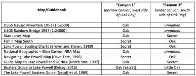
Yes, there's a lot of confusion over the names of those two canyons, and it's not only on the Stan Jones and Fish n Map Co's maps. I've got about 10 different maps of the lake, and they are all over the place. On the attached image, I've made a list of where they all land on naming those canyons... To make it easier to follow, I'm calling the skinny little canyon on the west entrance of Oak Bay "Canyon 1", and the wider one in the back of (south side of) Oak Bay "Canyon 2"...

A few interesting things come out of all this. For one, there is no consensus about what to call those two canyons. But it is is clear that the USGS maps, both before and after Lake Powell, call the skinny canyon "Oak Canyon". They don't have a name for the wider canyon. And to them, there is no "Secret" Canyon. National Geographic follows the USGS naming convention. Maybe this is the most "accurate way" to name them, but that's not how other mapmakers (and the public) have seen it.

A few of the maps (Stan Jones and and a couple others) kept the USGS convention for Oak Canyon, but added the name "Secret" to the wider canyon. Not sure why. But it seems that the more common use of the name "Secret" was applied to the narrow canyon, not the one Jones calls "Secret", and several of the maps show that, and switch Oak to the wider canyon. How and why it's hard to say. Your guess is as good as mine.

Michael Kelsey tries something novel in the later editions of his book, acknowledging the USGS name of Oak Canyon, but calling it "Secret" in parentheses because he knows a lot of maps label it that way. He then calls the wider canyon "Little Oak Canyon", the only map to do that. And to add to his own confusing logic, he acknowledges that the earlier editions of his book called the skinny canyon "Secret Canyon".

No wonder everyone was (and still is) confused!!

And just to put an exclamation mark on all this, Katie Lee in her river journals of the mid-1950s, gave the skinny canyon (the only canyon with a mouth at the river) the name "Wishbone Canyon". I actually can understand that name, because the way the canyon entered the river does look a little like the way the forks of a wishbone join. But no one has really called it "Wishbone" since...

I guess we can take a vote...

Personally, I think the name Secret Canyon makes sense for the narrow canyon, but I understand that's not its original name. But it just feels right to me. But one thing's for sure--"Secret" makes no sense at all for the wider canyon... not sure what Stan Jones and others were thinking... there's nothing Secret about it, especially when all the houseboats start jockeying for portion in the back of Oak Bay... And that canyon in the back of Oak Bay just sounds like it should be "Oak Canyon"...
Confusion over Secret and Oak Canyon.jpg
 
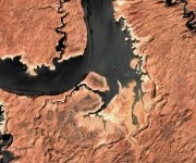
Here's an up-to-date low-res image of Oak Bay, taken 5-13-21, lake level 3561. Not much of a bay left, but clearly you can now see the original path of "Oak Canyon" (or is it "Secret Canyon"?), and now that's pretty much the way you'll need to take a boat if you're going that direction...

Houseboat camping potential in that area is going to be limited this summer...

Oak Bay 3561 05-13-21.jpg
 
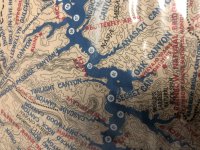
The Stan Jones map adds one more layer of mystery and confusion to this story. On the map, he labels the narrow canyon on the west side of Oak Bay as "Oak Canyon", and the wider one on the south side of the bay as "Secret Canyon". Now he's not the only one to do that, but what's really strange is that if you flip over his map and read the descriptions of the canyons (I know, who does that?), here's what it says about Secret Canyon:

"To the extreme west of Oak Canyon's mouth this tiny gorge has walls so close together that, in places, the sky cannot be seen above. One small boat can cruise a significant distance to the end. Beyond lake water the chasm can be hiked across a floor of river rock and into small grottos with interesting geology..."

That is a perfect description of the narrow canyon on the west of Oak Bay, one that many maps call Secret Canyon... except the Stan Jones map labels it as Oak Canyon! So his description and map don't match. His phrase "to the extreme west of Oak Canyon's mouth" is also curious... does he mean "at the extreme west end of Oak Bay"? Probably. Or does it mean he is actually describing Oak Canyon as labelled on the map, but for some reason it's listed as Secret Canyon on the back? Confusing.

Of course, to liberally paraphrase Shakespeare from Romeo and Juliet, what's in a name? That which we call a canyon by any other name would look the same...
 
JFR- just excellent analysis as always.......... my Stan Jones mapView attachment 13002 shows the larger one labeled Oak and marks Navajo Stairs and Moki Steps (so we call it Stairs and Steps Canyon) I walked back for 1 hour along the little stream and it has Cottonwoods/Willows and shade along the way- very nice hike
That's interesting! And different from my Stan Jones map (see below--the labels for Oak and Secret are switched!). This map isn't dated, but is post-2004 for sure. It's also called the "Stan Jones & Steve Ward" map...

So there's some differences even among the various versions of the Stan Jones map...hmm...

IMG_6337.jpg
 
My map is 1992 I think. It still has price tag 3.95 and has the ‘proposed’ site of antelope point marina

now JFR- please start new thread and give me story on my favorite hike- Aleson arch /elephant arch/something eagle arch - shown in different places on different maps. I come upriver from oak bay and park in little cove at about MM78 past rincon - Love to hear your analysis when you have time
 
That's interesting! And different from my Stan Jones map (see below--the labels for Oak and Secret are switched!). This map isn't dated, but is post-2004 for sure. It's also called the "Stan Jones & Steve Ward" map...

So there's some differences even among the various versions of the Stan Jones map...hmm...

View attachment 13003
My 1986 AAA map lists Secret canyon in the index map location E-7 same as oak but it’s not displayed on the map. Oak canyon is described as “short beautiful canyon on the south end of the wide bay”
 
Status
Not open for further replies.
Back
Top