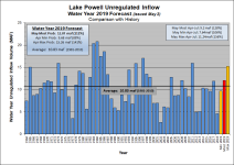
And if I'm reading this right, and that we can expect a total of 9.2 MAF +/- inflow, here's what it means for lake level rise. Since we know the BOR plans to release 9.0 MAF for water year 2019, and they've already released 5.6 MAF, that means they still need to release another 3.4 MAF by Sept 30. We also have already accumulated 2.8 MAF out of the projected 9.2 MAF inflow, so there's still 6.4 MAF left to come into the lake this season. So if you subtract 3.4 (projected outflow) from 6.4 (projected inflow) you get a likely net inflow of 3.0 MAF from now till the end of Sept. That translates to a total lake volume of 13.0 MAF at the end of September, which is about elevation 3612.
But I'd guess that we'll see a lake level peak a bit higher than that, because most of the inflow will happen between now and the middle of July, whereas releases will happen more steadily through September. Let's make some assumptions. If we assume 50% of the 3.4 MAF release from now to Sept 30 will happen in Aug-Sept, that would mean net release through July would be 1.7 MAF... and assume 80% of the projected remaining 6.4 MAF inflow to the end up Sept happens through July--this would be 5.1 MAF. In this case, net inflow by the end of July would be about 5.1-1.7 = 3.4 MAF... And if that holds true, you've got a peak lake volume of 13.4 MAF at the end of July, which is about 3617.
All rough back of the napkin guesses, but probably in the ballpark.
Of course, if it keeps snowing...