Stateline Aux Ramp - 2021/2022 w/Pictures

Rivergoer

Keeper of San Juan Secrets
Here’s a look back at 2021-2022 when the lake elevation reached a low of approx 3,519’. Today, the lake is 6’ higher than the low point back in May 2022. At current rate of decline, the lake will again reach that level in 6 weeks (around mid-Aug). Hopefully these images will help folks visualize/anticipate conditions as they plan trips this summer into Fall 2026.

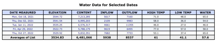
Photos below were taken on the dates shown in this table
IMG_2029.jpeg

It’s important to note the 26-week elevation change from October 2021 through end of April 2022 was -22’ or a little under -1’ per week on average.

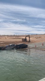
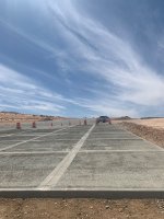
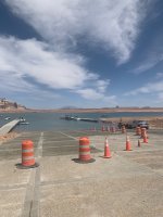
Here’s Stateline Aux October 18, 2021 Elevation 3,544’. This was before pouring of new concrete extensions, launching on steel boiler plates no problem.
IMG_3742.jpeg

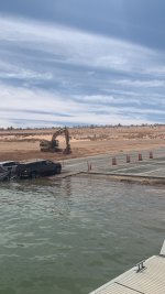
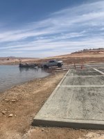
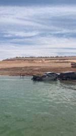
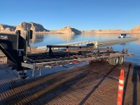
December 2, 2021 Elevation 3,441’. Three feet lower, large houseboat launches completely on boiler plate with no issues. Still pre-ramp extension.
IMG_3841.jpeg

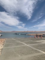
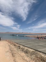
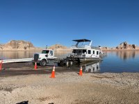
January 11, 2022 Elevation 3,535’. Three months since October, the lake is now 9’ lower, concrete extensions in-progress. Single-lane launching still available to all vessels on boiler plates.
IMG_3958.jpeg

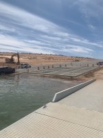
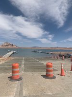
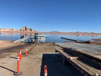
April 29, 2022 Elevation 3,522’
NOTE this was 3’ LOWER than current lake elevation is today (3,525’). The Aux ramp will again look like this by the end of July to 1st week in August 2026. Concrete ramp extension complete, shoreline exposed a few feet below end of concrete, steel boiler plates installed the entire width. We had just launched our 36’ houseboat toward the right (south) side of the photo, no problem at all.
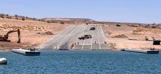
IMG_4532.jpeg

So, the big question is how far down does the natural terrain go? It’s been stated elsewhere on the forum the grade continues quite a ways further. If that’s true, it shouldn’t be a problem to repeat the above concrete extension/boiler plate process Fall/Winter 2026-2027. Fingers crossed…🤞🤞
 
Here’s a look back at 2021-2022 when the lake elevation reached a low of approx 3,519’. Today, the lake is 6’ higher than the low point back in May 2022. At current rate of decline, the lake will again reach that level in 6 weeks (around mid-Aug). Hopefully these images will help folks visualize/anticipate conditions as they plan trips this summer into Fall 2026.

Photos below were taken on the dates shown in this table
View attachment 36087

It’s important to note the 26-week elevation change from October 2021 through end of April 2022 was -22’ or a little under -1’ per week on average.

Here’s Stateline Aux October 18, 2021 Elevation 3,544’. This was before pouring of new concrete extensions, launching on steel boiler plates no problem.
View attachment 36088

December 2, 2021 Elevation 3,441’. Three feet lower, large houseboat launches completely on boiler plate with no issues. Still pre-ramp extension.
View attachment 36089

January 11, 2022 Elevation 3,535’. Three months since October, the lake is now 9’ lower, concrete extensions in-progress. Single-lane launching still available to all vessels on boiler plates.
View attachment 36090

April 29, 2022 Elevation 3,522’
NOTE this was 3’ LOWER than current lake elevation is today (3,525’). The Aux ramp will again look like this by the end of July to 1st week in August 2026. Concrete ramp extension complete, shoreline exposed a few feet below end of concrete, steel boiler plates installed the entire width. We had just launched our 36’ houseboat toward the right (south) side of the photo, no problem at all.
View attachment 36091

So, the big question is how far down does the natural terrain go? It’s been stated elsewhere on the forum the grade continues quite a ways further. If that’s true, it shouldn’t be a problem to repeat the above concrete extension/boiler plate process Fall/Winter 2026-2027. Fingers crossed…🤞🤞
We concur, we were there,the thing that realy concerns and scares us is the amount of trucks/trailers in the parking lot !!
 
Here’s a look back at 2021-2022 when the lake elevation reached a low of approx 3,519’. Today, the lake is 6’ higher than the low point back in May 2022. At current rate of decline, the lake will again reach that level in 6 weeks (around mid-Aug). Hopefully these images will help folks visualize/anticipate conditions as they plan trips this summer into Fall 2026.

Photos below were taken on the dates shown in this table
View attachment 36087

It’s important to note the 26-week elevation change from October 2021 through end of April 2022 was -22’ or a little under -1’ per week on average.

Here’s Stateline Aux October 18, 2021 Elevation 3,544’. This was before pouring of new concrete extensions, launching on steel boiler plates no problem.
View attachment 36088

December 2, 2021 Elevation 3,441’. Three feet lower, large houseboat launches completely on boiler plate with no issues. Still pre-ramp extension.
View attachment 36089

January 11, 2022 Elevation 3,535’. Three months since October, the lake is now 9’ lower, concrete extensions in-progress. Single-lane launching still available to all vessels on boiler plates.
View attachment 36090

April 29, 2022 Elevation 3,522’
NOTE this was 3’ LOWER than current lake elevation is today (3,525’). The Aux ramp will again look like this by the end of July to 1st week in August 2026. Concrete ramp extension complete, shoreline exposed a few feet below end of concrete, steel boiler plates installed the entire width. We had just launched our 36’ houseboat toward the right (south) side of the photo, no problem at all.
View attachment 36091

So, the big question is how far down does the natural terrain go? It’s been stated elsewhere on the forum the grade continues quite a ways further. If that’s true, it shouldn’t be a problem to repeat the above concrete extension/boiler plate process Fall/Winter 2026-2027. Fingers crossed…🤞🤞
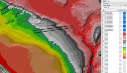
Back in August, 2021 the NPS said that the Stateline Auxiliary Ramp could be extended all of the way down to 3,450' elevation. The bathymetric surveys show a steep drop at the end down to about 3,423' elevation. That elevation is approximately the bottom of Waheap Bay. The attached photo is a visualization of the bathymetric data that I did a few years ago (July 2021), with elevations in meters listed on the side with a color key.

Remember that there is not a whole lot of volume change between 3,450' and 3,370' (official dead pool). But the reservoir would still reach to Moqui Canyon at that level.
 

Attachments

  • WahweapContour4Annotated.jpg
    WahweapContour4Annotated.jpg
    206.8 KB · Views: 30
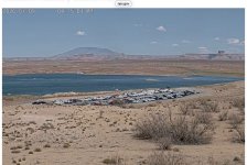
I don’t recall seeing any plans to expand the lower Aux parking lot. If true, given ramp closures at Wahweap, AP and Lone Rock, one can reasonably assume the parking lot will continue to look just like it does in the webcam right now at least through Labor Day…pretty much full.

There’s still ample parking up top in the paved Stateline Main parking area but it’s a LOONNG walk! IMG_2030.jpeg
 
Back
Top