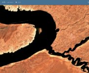
Shallow Area - Main Channel - Opposite Moki Canyon

Status
Not open for further replies.
The shallow in front of Moki has now appeared. We saw it just below the surface last Sunday. A 21' I/O went over the top of the shallow and abruptly slowed once they saw their depth gauge. When I came back on Friday, there was sand showing in the waves. A houseboat coming up lake was headed straight for it until they saw it and diverted quickly toward the channel marker. There is a deeper section as you approach the shoreline, but I think to be safe, it should be avoided entirely and everyone should pass up toward the channel marker.IMG_5061.jpeg
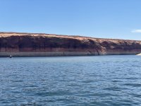
 
This is the area I reported on May 21 -- at that time it surprised me but there was still 4-5 feet--- at that time -- Good pics shows the unexpected as you head up river -- We all use to cut that corner -- not anymore
 
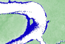
The depth data shows a huge shallow area, so you want to stay in the eastern 1/3 of the full pool channel until you are north of the south shoreline running east-west uplake from Moki Canyon. On the bright side, that area will be fully exposed soon, and the bottom drops off sharply outside that shelf.
 
It’s a web based service called Sentinel Hub. The link is on the home page. Great service, but the maps are fairly pixelated.
First time I have played with it! It seems like some additional value can be found in looking at the different spectra. You can see that the whale at Moki is more than it seems, since there is a lot more underwater...
Screen Shot 2021-08-27 at 3.20.34 PM.png
 
You can see that the whale at Moki is more than it seems
Yes, when it was only "yellow water" earlier in the year you could tell that it was a very large mud plain that was just below the surface. Definitely want to follow the channel markers and not cut corners(pretty much anywhere). New features that haven't been seen in 50-60 years are being exposed every day.
 
It’s a web based service called Sentinel Hub. The link is on the home page. Great service, but the maps are fairly pixelated.
I am huge fan of Sentinel Hub, learned about it here on WW (thanks whoever that was that provided the link)!

It seems some satellites give a better images than others, and the ones that give an image for a particular time period seems to change. Some of the images are quite detailed, others are pixelated as you said. The website takes some messing around to get familiar with it, but it is pretty awesome to have nearly real-time satellite images!
 
Yes, when it was only "yellow water" earlier in the year you could tell that it was a very large mud plain that was just below the surface. Definitely want to follow the channel markers and not cut corners(pretty much anywhere). New features that haven't been seen in 50-60 years are being exposed every day.
Seeing it in person it is very apparent that there is shallow water everywhere on that corner. As I mentioned earlier in the thread, we saw boats as we headed up and down lake that weren't quite as aware that they needed to head all the way to the channel marker.
 
Status
Not open for further replies.
Back
Top