Wayne's Words Archive
Active Member
October 7, 2006 - Mike and Janna O'Loughlin (MoJo)
Lake Elevation: 3602
Peekaboo Arch - San Juan

Mike and Janna O'Loughlin (MoJo) hiked Peekaboo Arch on Oct 7, 2006. We're happy to share our perspective and experience with you. Peekaboo is a rim arch found along the San Juan arm just past Deep Canyon. The 4.2 mile R/T hike will take you between 4-5 hours and has a terrain rise of 880 feet. I highly recommend standard hiking boots rather than your river sandals. Also, pack along your normal hiking gear (water, hat, sunscreen... we found a rope came in handy). You'll find a log journal in the bowl of the arch so all those successful can tag their victory. Two other hikers I offer as reference guides are Tony Ferris and Alan Silverstein, without their information we could not have made the hike.

GPS N37 11.051 W110 45.110 Beach your boat here.
Start the hike by walking east up the wash about 30-50 yards. Turn right/south and head for the ridge. You'll be able to find your own passage way up the ridge. At the top, mark your waypoint (or use cairn) - you'll want to be able to find it on the return.

GPS N37 10.965 W110 45.018 Once on top you should be about here.
Head east, the terrain is mostly flat.
Walk to the south of the base of these mountains.

This is the view looking south towards Navajo Mountain.

GPS N37 10.855 W110 44.393 You'll start your switchback up this rocky ridge. There are cairns along the way and you'll be able to recognize a trail if you look for it. The GPS is the approximate location of the first cairn.

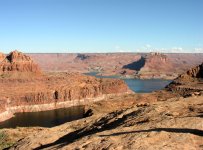
GPS N37 11.029 W110 44.377 View from the top.

From the top of this 2nd ridge you'll skirt back to the left/west for about 70 yards before heading north. This is the view to the north. You'll recognize and follow a sheep/deer trail most of the way before your next course change back to the east.

GPS N37 11.447 W110 44.224 When you make the turn back to the east you'll cross over two slick rock ridges. Look for the cairns.

View from the top -- you're almost there.

Look for the Flintstones back door. Climb down into the water hole and enter the arch through the "back door". The day we made the hike the water hole was full of water (day after the "Big Flood of Oct 2006"). We couldn't get in. So, please sign our names in proxy!

GPS N37 11.491 W110 43.874 You made it!! Congratulations!!!
Lake Elevation: 3602
Peekaboo Arch - San Juan

Mike and Janna O'Loughlin (MoJo) hiked Peekaboo Arch on Oct 7, 2006. We're happy to share our perspective and experience with you. Peekaboo is a rim arch found along the San Juan arm just past Deep Canyon. The 4.2 mile R/T hike will take you between 4-5 hours and has a terrain rise of 880 feet. I highly recommend standard hiking boots rather than your river sandals. Also, pack along your normal hiking gear (water, hat, sunscreen... we found a rope came in handy). You'll find a log journal in the bowl of the arch so all those successful can tag their victory. Two other hikers I offer as reference guides are Tony Ferris and Alan Silverstein, without their information we could not have made the hike.

GPS N37 11.051 W110 45.110 Beach your boat here.
Start the hike by walking east up the wash about 30-50 yards. Turn right/south and head for the ridge. You'll be able to find your own passage way up the ridge. At the top, mark your waypoint (or use cairn) - you'll want to be able to find it on the return.

GPS N37 10.965 W110 45.018 Once on top you should be about here.
Head east, the terrain is mostly flat.
Walk to the south of the base of these mountains.

This is the view looking south towards Navajo Mountain.

GPS N37 10.855 W110 44.393 You'll start your switchback up this rocky ridge. There are cairns along the way and you'll be able to recognize a trail if you look for it. The GPS is the approximate location of the first cairn.

GPS N37 11.029 W110 44.377 View from the top.

From the top of this 2nd ridge you'll skirt back to the left/west for about 70 yards before heading north. This is the view to the north. You'll recognize and follow a sheep/deer trail most of the way before your next course change back to the east.

GPS N37 11.447 W110 44.224 When you make the turn back to the east you'll cross over two slick rock ridges. Look for the cairns.

View from the top -- you're almost there.

Look for the Flintstones back door. Climb down into the water hole and enter the arch through the "back door". The day we made the hike the water hole was full of water (day after the "Big Flood of Oct 2006"). We couldn't get in. So, please sign our names in proxy!

GPS N37 11.491 W110 43.874 You made it!! Congratulations!!!
