Houseboat fuel and range

Status
Not open for further replies.
We fish and have three fishing boats. We usually go to Paiute Canyon in the San Juan arm so we're used to distances that require extra fuel. Will not go to DR in the middle of a trip because of the lost fishing time and the fuel used to get fuel. We have taken as much as 70 gallons. Don't suggest you take that much but 20 or thirty gallons will be appreciated sooner or later. We take a hose and a cheap hand pump that fits the hose. Since the fuel is on the top deck, it doesn't take much to get the flow started. Have some one with brains holding the hose down below so as not to overfill a fuel tank. You will here the timbre change when it gets close to being filled. The guy up top just pulls the hose out of the container when told. Any fuel we have left goes into the engine or gen tanks. It is not uncommon for the houseboat fuel tanks to be low when you leave the dock. Trust me, I worked there for 10 years. And yes, JFR is right, top-off is free. By the way, a little grease on the gears goes a long way. They work hard for little pay...Pick a friendly porter, tell them your expectations and you will be light years ahead of someone who t ries to get management in the office to help you. I always watch the porters style for a few minutes, you will know who you want to tip. If someone is grumpy, move on to the next. There is always one or two who stand out. Such is life. Fishing off the back of your houseboat will be a gas. Throw out some chum to get started. I've never been confronted about fuel on the top deck but we don't flaunt it. We use quality containers that seal well. This year we plan on hanging closer, probably Padre area.. Take one of your power boats with a vhs radio and a chair or something/someone to leave on a beach of your choosing. You probably will be surprized how hard it can be to find a suitable beach and a powerboat will be much faster scouting with. Good luck.
 
Thanks again! More great info. Yeah I can see that it can’t hurt to have some extra fuel. I’ll see what containers we can get together before the trip.

Agree with you about tipping porters well—I’m sure they work hard and should be taken care of. I guess we might arrive after closing time for pre-board, so I assume the bulk of the porter work will be done by us! ;)

As for Last Chance, we’re not married to the idea. Just combing the maps it looked like there are some neat areas to explore and camp in. But if you’ve Gad experience with it filling up and possibly some bad winds, it may not be the only option we’re up for. It’s just about the right distance away from Wahweap without straining fuel too bad, but maybe we could go a little past.

Been looking at West and Rock Creek as possible options too.
 
Not many beaches in West until the back. Some nice places and good fishing in Rock Creek. Study Google earth on years with similar water level. Any part of the lake can get plenty windy but what a great feeling when you're anchored well or better yet tied to big rocks and you feel safe.
 
Not many beaches in West until the back. Some nice places and good fishing in Rock Creek. Study Google earth on years with similar water level. Any part of the lake can get plenty windy but what a great feeling when you're anchored well or better yet tied to big rocks and you feel safe.
The area outside the entrance to West Canyon usually has pretty reliable beach areas at lower lake levels, either on the northeast side (opposite Gregory Butte), or even right along the base of Gregory Butte. Friendship Cove should have something. Rock Creek could work. The mouth of Dungeon could work too, but at such low lake levels, your options there become much more limited. As for checking GoogleEarth imagery for years with similar lake levels, that's a really good idea, but there isn't much there to simulate current lake levels. There are over 30 different dates of imagery from 1992-2019 taken that cover at least part of the lake, but only a few of those cover the whole lake. Here's the most common images they have with the best overall coverage, and the lake levels they were taken at:

8-24-04 - 3574
4-6-15 - 3591
5-29-13 - 3598
7-12-06 - 3609
6-22-09 - 3638
9-14-11 - 3655

By far the best (easiest to see the details) imagery in that group are the 2013 and 2015 images, and the 2011 image isn't bad. The 2004 images, which are closest to current lake levels, are just okay, and hard to see the details when you get in close. But if you look at the 2015 image, it'll at least give you a rough idea of what to expect.
 
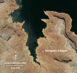
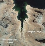
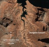
...and just to illustrate what lower lake levels can do to beach potential, Dungeon Canyon is Exhibit A. The three images attached cover the exact area, showing Dungeon Canyon at 3558, 3591 and 3655. At higher levels, there's all sorts of beach area. But a dramatic difference when it's low...

...on the other hand, there will no doubt be places on the lake (mostly smaller coves here and there) where small beaches are revealed at the new lower levels, but that will require some scouting and a keen eye...

By the way, there are a few parts of the lake (especially in the southern end) where there's imagery taken on 3-7-05, when the lake was at 3558. Dungeon Canyon happens to be one of those places. That imagery is your best crystal ball for the immediate future, though unfortunately there's just not much aerial coverage at this level.
 

Attachments

  • Dungeon 3655.jpg
    Dungeon 3655.jpg
    334 KB · Views: 45
  • Dungeon 3591.jpg
    Dungeon 3591.jpg
    347.7 KB · Views: 45
  • Dungeon 3558.jpg
    Dungeon 3558.jpg
    350.5 KB · Views: 45
...and just to illustrate what lower lake levels can do to beach potential, Dungeon Canyon is Exhibit A. The three images attached cover the exact area, showing Dungeon Canyon at 3558, 3591 and 3655. At higher levels, there's all sorts of beach area. But a dramatic difference when it's low...

...on the other hand, there will no doubt be places on the lake (mostly smaller coves here and there) where small beaches are revealed at the new lower levels, but that will require some scouting and a keen eye...

By the way, there are a few parts of the lake (especially in the southern end) where there's imagery taken on 3-7-05, when the lake was at 3558. Dungeon Canyon happens to be one of those places. That imagery is your best crystal ball for the immediate future, though unfortunately there's just not much aerial coverage at this level.
Great demonstration of the satellite imagery! Thanks for the tips. By the way, can you compare timeline imagery like that on the Google Earth mobile app? Or is it desktop only? I can’t find the best way to find specific dates.
 
Great demonstration of the satellite imagery! Thanks for the tips. By the way, can you compare timeline imagery like that on the Google Earth mobile app? Or is it desktop only? I can’t find the best way to find specific dates.
I don't have the mobile app, so don't have the answer. But on the desktop, it's pretty easy to scroll through historic imagery using the little clock face icon with the green arrow up in the toolbar... then I just correlate the dates shown on the images to the water database to get lake levels...
 
One other thing. We have multiple beach locations plotted in areas we can go for different wind scenarios... The week before you go on the trip the wind directions each day will start to firm up and then you can choose one of the beach locations that best suit that wind direction. For example a wind out of the west would find us on the west side of a canyon with fishing structure that will allow us to still fish in heavy winds because we would be on the leeward side of the canyon. Think Last Chance. If the winds will be out of the north think Padre Canyon. We have fished in 30 mph winds because we were protected. We are going for a week on May 7th so we are already discussing this years plans. That is half the fun of these trips. JFR has now got me thinking about West.
 
Hey all. Been using this site for a while for great info, thank you much. Found this post researching actual 48' Navigator numbers as I'll be out of Bullfrog with one in a couple of weeks. Thought I'd leave actual numbers here that I logged on our last trip in the 46' Voyager in case anyone finds and can use them.

They advertise the Voyager with 60hp engines and a 4kW gen; 8-12mph @ 14gph (I assume total) and 1-2gph on gen.

My actual numbers after refueling twice, keeping detailed logs on gen usage and cruise times and same results both times was engines 3gph total (2.3mpg) with estimated .5gph on gen. Ridiculously lower than advertised.

8hrs cruising/7hr gen = 23gals at fill up.
7.25hrs cruising/17hrs gen = 32gals

Same engines on the Navigator but heavier, etc with a 8kW gen so even doubling those numbers is well below advertised of 10gph each and 4gph on gen.
 
We’ve got our very first houseboat trip planned for the end of May, and we’re trying to figure out our range for areas to target camping. I thought some of the experts on here could help with the planning process!

We’re leaving out of Wahweap, and we have a 48’ navigator. Also a 19’ powerboat.

I assume the cut will be closed. And with that in mind, we’re hoping to target Last Chance as our destination. Just not sure we’ll have enough fuel to make it there and back, plus the generator running each day.

So our rental has a 115 gal main tank, and a 115 gal toy tank. The houseboat motors run 10 gallons per hour EACH, and I estimate around 10 mph average. So that’s 0.5 miles per gallon.

Generator is estimated at 4 gallons per hour...

We’ll be departing on a Thursday, returning the following Wednesday. Now I just have to calculate the safe range of this rig! :unsure:
Just returned from our trip on a 48 Navigator. The gen is spec'd at 1gph for the 8kWH: https://www.westerbeke.com/operator's manual/49735 rev 6 operators manual.pdf

The 60 Merc engines are spec'd at 2.6gph each/4,000 rpm:

I used 57.7gals out of the left tank that feeds both engines and gen. Total engine time running from Bullfrog to Davis Gulch (off Escalante) returning and various putting in between was 15.9 hours @ 4,000rpm/5.5mph cruising towing a wave runner, running generator 16.2hrs.

So, averaged 3.2gph total and .5gph on gen or 2.6gph total with 1gph on gen. Hard to believe but they're accurate numbers.
 
If going to Last Chance we usually have good luck with beaches in Powell Bay...... 37.115405, -111.289668
Thank you! Good info
Just returned from our trip on a 48 Navigator. The gen is spec'd at 1gph for the 8kWH: https://www.westerbeke.com/operator's manual/49735 rev 6 operators manual.pdf

The 60 Merc engines are spec'd at 2.6gph each/4,000 rpm:

I used 57.7gals out of the left tank that feeds both engines and gen. Total engine time running from Bullfrog to Davis Gulch (off Escalante) returning and various putting in between was 15.9 hours @ 4,000rpm/5.5mph cruising towing a wave runner, running generator 16.2hrs.

So, averaged 3.2gph total and .5gph on gen or 2.6gph total with 1gph on gen. Hard to believe but they're accurate numbers.
Excellent info, thank you! That’s encouraging about the usage. I’m hoping we won’t have any problems camping around last chance and getting back to Wahweap on a single fill up.
 
Looks like it was damaged by the wind last night.... the fuel dock is pushed off to the side a lot...
 
BigBassMan - winds can be bad, and as a general rule more likely in the afternoon, evening. We try to anchor by 2-3PM at the latest . Another good reason to anchor that first day close to the marina and find your spot on day 2.

We've found it's much more relaxing and enjoyable by taking some of the pressure off that first day. There's enough to do with getting to Powell, unloading your vehicles, getting everything put away in the boat. We're fortunate in that we've always had a buoy or slip, so it's really easy to stay put the first night - go for a swim, take the speedboat to see a few sights, get to bed early, and then head out at first light the next morning
 
BigBassMan - winds can be bad, and as a general rule more likely in the afternoon, evening. We try to anchor by 2-3PM at the latest . Another good reason to anchor that first day close to the marina and find your spot on day 2.

We've found it's much more relaxing and enjoyable by taking some of the pressure off that first day. There's enough to do with getting to Powell, unloading your vehicles, getting everything put away in the boat. We're fortunate in that we've always had a buoy or slip, so it's really easy to stay put the first night - go for a swim, take the speedboat to see a few sights, get to bed early, and then head out at first light the next morning
Great advice, thank you! Yeah, we're leaning toward staying put the first day/night. We can take the powerboat out and explore the dam area, and maybe even make a practice run through Antelope. And maybe fish a bit! Does anyone know if anchoring south of the marina in wahweap bay is a possibility right now with lake levels so low? Or maybe just stay put in the marina if they allow it for one night!
 
I'd just stay put in the marina if you don't plan to head up lake the first day. Why go through the hassle of anchoring if you don't have too...
 
Great advice, thank you! Yeah, we're leaning toward staying put the first day/night. We can take the powerboat out and explore the dam area, and maybe even make a practice run through Antelope. And maybe fish a bit! Does anyone know if anchoring south of the marina in wahweap bay is a possibility right now with lake levels so low? Or maybe just stay put in the marina if they allow it for one night!
This morning, Lots of houseboats were parked in the coves on the east side of Wahweap bay between Wahweap Marina and the main channel.
 
I'd just stay put in the marina if you don't plan to head up lake the first day. Why go through the hassle of anchoring if you don't have too...
Yep, that's what we were worried about, the pain of anchoring. But it would be good practice, at least! But it could be nice to just stay put.
This morning, Lots of houseboats were parked in the coves on the east side of Wahweap bay between Wahweap Marina and the main channel.
Thanks, Wayne!
 
That boat has 60 hp 4 strokes on it and an 8.5 westerbeke. You'll have plenty of fuel but we always take some extra cans on the top deck just so not to pay 5.30$ a gallon on the return. That boat has a nice invertor system so you only need to run the gen long enough to keep the batteries up which is usually done at night while preparing dinner and a short while in the morning during breakfast. about 4-6 hours each day. Did you consider a pre-board? We consistently get 20% off the preboard price. You have to whine and cry a little about being first timers but I'd bet you could get it. That would put the preboard cost at about 380$. If you get an instructor to check you out on the afternoon you get the boat you can leave at daybreak, missing a lot of traffic. Find a motivated, friendly porter on the dock, tip them well and you will get your boat in enough time to get your instruction that afternoon. The office will give you the spiel about no guarantees to get the boat before 8 pm but the real service is done on the dock. The porters and instructors know the deal. If you do pre-board get there around 3 in the afternoon, get your paperwork done in the office and then go to the boarding dock to start greasing the wheels. I always tell my dock contact up front my expectations and start with a 20 dollar bill to show I'm real. Good luck. Yeah it says no extra fuel but this is at least my 30th rental and never has a porter said a word. We have brought as many as 16 cans for our trips to the upper San Juan. We run between 3000 and 3500 rpm but honestly the boat is so slow that 3500 is the norm.
 
Status
Not open for further replies.
Back
Top