Sampson767
Active Member
I'm anxiously awaiting your trip and report! I am also a HB newbie, seeing you go for the 75 footer with a big group on your first trip is inspiring! Hope you guys have a blast.


The west side of Last Chance is a good choice.Lots of good advice here. I think for your huge group and "Big Trip" you can't really beat Last Chance for its grandeur and its protection from storms in July. Plus there are a lot of spaces to park, it's huge. It's also less traveled being past Padre Bay especially since there is no fuel at Dangling Rope now. Conventional wisdom among a lot of us would be to grab a spot facing West against the huge cliffs because many of us Powell Heads feel like the worst Monsoons blow in from that direction.
Range should not be an issue especially if you run the engines at 70% instead of wide open as is the temptation. You maybe get another one or two miles per hour in a big houseboat WOT but your fuel consumption goes up dramatically, like almost double. So leave early, slow down and take it all in.
If I had any advice it's not to let the planning get it the way of having fun. "Plans work until the shooting starts" Eisenhower. Big outings on Powell are unpredictable and adapting and overcoming can be part of the fun but in some sense you have to go with the flow. In a way we have to go to Powell she doesn't come to us. I hope you have a great time!

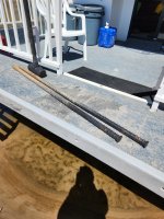
Kind of interesting - similar to people that drill into the rock (don't do that), and assuming the sand is able to provide enough resistance, it's a partially proven concept.When we rented a houseboat at lake Mead this year, the houseboat came with 4 1" diameter x 4' long pieces of rebar and a sledge hammer to anchor the boat with. The boat was 50' so only two ropes provided to anchor with. No anchors on board.....only rebar. You pound them in at 45 degree angles to form an X. Then you pull the rope tight from the back cleat of the boat and tie it to the rebar. The X acts like a cleat and you tie the rope the same way as you would normally use a cleat. The instructions said to drive the rebar in until about 1' was sticking up. Pulling them back out was way easier than I thought it would be and much quicker and easier than digging holes. I'm thinking of trying this next time I go to Powell.


Hmmm, ok that's a bummer if there is a do not pass line...I will check that. Hopefully not...Double check, I went last week and they drew a fat marker on a map and said "don't go past that line" and had me sign. I did not know that and had to adjust on the fly. I wish I had kept it, but the line was basically near the end of Padre and the mouth of West. Apparently, their mechanics can't get much farther without Dangling Rope or something. I mean technically I could have went farther, but I suppose you assume mechanical risk. Maybe it's different with a bigger boat though.
A good beach is crap shoot though with all the other houseboats and changing water levels. #1 thing is you or someone else leave the houseboat relatively soon and scout ahead. I found 4 'decent' spots and we ended up in a small offshoot near the front of Face Canyon. It actually turned out to be an amazing spot.
View attachment 28160

That’s interesting about “the line on the map.” I’ve never encountered anybody doing that when I’ve rented a boat out of Wahweap in recent years, but then again, I haven’t rented anything bigger than 53 feet. In my experience, I’ve never had any trouble taking a 46- or 53-foot houseboat from Wahweap to the Escalante and back, no refueling. Might be different for larger boats. I know they don’t want a lot of people running out of gas in remote areas, but there should be no issue at all going as far as Rock Creek and back, even Rainbow Bridge IMO.Apparently, their mechanics can't get much farther without Dangling Rope or something. I mean technically I could have went farther, but I suppose you assume mechanical risk
Hoping this is the case. I may not be an experienced houseboater but, I am an experienced boater… and I’ve studied and I’m studying this lake to the point of obsession.That’s interesting about “the line on the map.” I’ve never encountered anybody doing that when I’ve rented a boat out of Wahweap in recent years, but then again, I haven’t rented anything bigger than 53 feet. In my experience, I’ve never had any trouble taking a 46- or 53-foot houseboat from Wahweap to the Escalante and back, no refueling. Might be different for larger boats. I know they don’t want a lot of people running out of gas in remote areas, but there should be no issue at all going as far as Rock Creek and back, even Rainbow Bridge IMO.
As for the difficulty of mechanics reaching past Dangling Rope, I learned something interesting from the mechanic who recently rescued me when I ran out of gas just south of Moqui. He said that Bullfrog-based mechanics cover the north end and all the way down to Rainbow Bridge. Wahweap-based mechanics cover the south end all the way up to Rainbow Bridge. So the lake is covered. It might take a while to be rescued if you’re in mid-lake, but it’s covered.
I do think it matters what kind of tone you use when you rent the boat. If you sound confident about where you’re going and project experience and familiarity with the lake, they don’t even bring up things like the “line on the map”, which to me is really more intended to keep inexperienced boaters out of trouble…
Yeah I've never had that happen before. My two previous spots were Wetherill and Oak Canyon/Bay. I don't think I give off an inexperienced vibe, but... Maybe it was the particular boat we got or they've had some issues lately.That’s interesting about “the line on the map.” I’ve never encountered anybody doing that when I’ve rented a boat out of Wahweap in recent years, but then again, I haven’t rented anything bigger than 53 feet. In my experience, I’ve never had any trouble taking a 46- or 53-foot houseboat from Wahweap to the Escalante and back, no refueling. Might be different for larger boats. I know they don’t want a lot of people running out of gas in remote areas, but there should be no issue at all going as far as Rock Creek and back, even Rainbow Bridge IMO.
As for the difficulty of mechanics reaching past Dangling Rope, I learned something interesting from the mechanic who recently rescued me when I ran out of gas just south of Moqui. He said that Bullfrog-based mechanics cover the north end and all the way down to Rainbow Bridge. Wahweap-based mechanics cover the south end all the way up to Rainbow Bridge. So the lake is covered. It might take a while to be rescued if you’re in mid-lake, but it’s covered.
I do think it matters what kind of tone you use when you rent the boat. If you sound confident about where you’re going and project experience and familiarity with the lake, they don’t even bring up things like the “line on the map”, which to me is really more intended to keep inexperienced boaters out of trouble…
We tighten our anchor ropes in a similar way. We dig the anchor holes and then after setting the anchor we dig it in by using the boat engines to move the boat to the side away from the anchor. We pull on the anchor until it no longer moves. This simulates the pull that the boat would experience from a strong side wind. When all the anchors are dug in, we manually tighten them so they are equally taut. We set 4 anchors for our 75 ft houseboat when the forecast calls for maximum wind gusts in the 20 to 25 mph range. If they are above that, we set the two bow anchors as well. On rare occasions when the wind is exceptionally strong from one direction we will we will skip the bow anchors and use that anchor to buttress the side experiencing the high winds.Anchorage is as personal a taste almost as food. Ask ten guys get 7different opinions. I go with sandy beach just at the wet line where wet meets dry sand and the sand is hard like concrete. I just put out four, two on each side as wide as I can. I tighten them up and stretch the ropes on one side with the motors and then use the cleats while still under power to tighten the other side. Then I pull power and they both snap tight. Keeping them tight is your best bet, wiggle room will start a tug of war and can lead to dislodged anchors. Mixing in a convenient huge bolder or two is also good but tight lines is still the key to me. Your rental will have ropes and anchors which should be adequate if you use them well.
Your experience with rentals about the line is a bummer. Going past lines on the map is the basis of most all of human progress. I hope you ignored it. One of my best trips ever to Maui my wife and I were given such a map, don't go past the Seven Sacred Pools in your rental car we won't come help you they said. So I did exactly that and saw the 7 climate zones of Maui on a dirt road from a Trans Am convertible. It was incredible, views of the rainforest and the big Maui Rainbows over them, grasslands leading to the blue ocean, black sand beaches and even cactus.Double check, I went last week and they drew a fat marker on a map and said "don't go past that line" and had me sign. I did not know that and had to adjust on the fly. I wish I had kept it, but the line was basically near the end of Padre and the mouth of West. Apparently, their mechanics can't get much farther without Dangling Rope or something. I mean technically I could have went farther, but I suppose you assume mechanical risk. Maybe it's different with a bigger boat though.
A good beach is crap shoot though with all the other houseboats and changing water levels. #1 thing is you or someone else leave the houseboat relatively soon and scout ahead. I found 4 'decent' spots and we ended up in a small offshoot near the front of Face Canyon. It actually turned out to be an amazing spot.
View attachment 28160
I agree, take "the line" with a grain of salt and don't be afraid to take calculated risks in general. I scouted spots past the line to the front of Last Chance, and just past West (which was my original planned area) but actually found a great spot in Face Canyon... so I settled for their little rule. Which turned out OK because it was quite a nice spot and I've never really hung out in the Padre Bay area so I was able to explore some new areas.Your experience with rentals about the line is a bummer. Going past lines on the map is the basis of most all of human progress. I hope you ignored it. One of my best trips ever to Maui my wife and I were given such a map, don't go past the Seven Sacred Pools in your rental car we won't come help you. So I did exactly that and saw the 7 climate zones of Maui on a dirt road from a Trans Am convertible. It was incredible, views of the rainforest and the big Maui Rainbows over them, grasslands and even cactus.
To me that is exactly why you go, the trepidatious won't. Destiny dances with the daring. It's D Day for heavens sake! I say ignore the line on the map, this is their one big trip, a year of planning. Go out and see what Powell really tastes like! BTW I think Last chance is at the line, it's just around the corner from Padre
Better to have an extra anchor out and not need it that to need it and not gave it out. You'll only do it wrong a few times, I learned the hard way swimming in the dark in a bad storm trying to get that extra line out.We tighten our anchor ropes in a similar way. We dig the anchor holes and then after setting the anchor we dig it in by using the boat engines to move the boat to the side away from the anchor. We pull on the anchor until it no longer moves. This simulates the pull that the boat would experience from a strong side wind. When all the anchors are dug in, we manually tighten them so they are equally taut. We set 4 anchors for our 75 ft houseboat when the forecast calls for maximum wind gusts in the 20 to 25 mph range. If they are above that, we set the two bow anchors as well. On rare occasions when the wind is exceptionally strong from one direction we will we will skip the bow anchors and use that anchor to buttress the side experiencing the high winds.
Too funny…I did the exact same thing in Maui with my wife…in a convertible mustang. Drive all the way around the road to Hana and then kept going (where the rental car company said was a no-go zone). We had exactly the same experience. I admit it was sketchy where it was a dirt road carved into the side of a cliff on the southwestern side of a volcano…no people or structures or any sign of civilization in sight for over an hour. But it was a great memory…Your experience with rentals about the line is a bummer. Going past lines on the map is the basis of most all of human progress. I hope you ignored it. One of my best trips ever to Maui my wife and I were given such a map, don't go past the Seven Sacred Pools in your rental car we won't come help you they said. So I did exactly that and saw the 7 climate zones of Maui on a dirt road from a Trans Am convertible. It was incredible, views of the rainforest and the big Maui Rainbows over them, grasslands leading to the blue ocean, black sand beaches and even cactus.
To me that is exactly why you go, the trepidatious won't. Destiny dances with the daring. It's D Day for heavens sake! I say ignore the line on the map, this is their one big trip, a year of planning. Go out and see what Powell really tastes like! BTW I think Last chance is at the line, it's just around the corner from the end of Padre

That will save a bunch of $$$ on fuel cost and time.Too funny…I did the exact same thing in Maui with my wife…in a convertible mustang. Drive all the way around the road to Hana and then kept going (where the rental car company said was a no-go zone). We had exactly the same experience. I admit it was sketchy where it was a dirt road carved into the side of a cliff on the southwestern side of a volcano…no people or structures or any sign of civilization in sight for over an hour. But it was a great memory…
That said, I am not a typical risk taker and usually follow the rules (I even succumbed to “the man” by buying an Utah AIS stamp even though many said don’t bother). Sounds like Last Chance might be the place to go. I’m also starting to wonder about even considering Wahweap bay itself. Seems like from the satellite views, there are houseboats beached on the north side of the that bay. I’m sure there are tons of people which likely makes that unadvisable though.
Wahweap Bay would be busy and roughToo funny…I did the exact same thing in Maui with my wife…in a convertible mustang. Drive all the way around the road to Hana and then kept going (where the rental car company said was a no-go zone). We had exactly the same experience. I admit it was sketchy where it was a dirt road carved into the side of a cliff on the southwestern side of a volcano…no people or structures or any sign of civilization in sight for over an hour. But it was a great memory…
That said, I am not a typical risk taker and usually follow the rules (I even succumbed to “the man” by buying a Utah AIS stamp even though many said don’t bother). Sounds like Last Chance might be the place to go. I’m also starting to wonder about even considering Wahweap bay itself. Seems like from the satellite views, there are houseboats beached on the north side of the that bay. I’m sure there are tons of people which likely makes that unadvisable though.