HAZARDS IN BULLFROG BAY

Status
Not open for further replies.
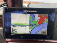
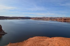
This was what it looked like back in Febuary. You actually need to stay southeast and hug the last point before crossing towards Halls marina. when heading north out of Bullfrog. If you shoot straight across towards Moki you will nail it. If there is not already some of it above the surface, it is with in inches of being there. If you compare it to the photo above it is huge.


FD25BBD1-62E7-4620-96B4-397F5AB3BBB5.jpeg
 
Last edited:
928-614-0820 is a TEXT ONLY # for violations, the other 2#’s are voice lines the NPS in Page. I think everyone should have the “Violation Text #” available. Sq
 
Last edited:
Thanks again gents.

Just to clarify, I guess what I'm asking, I have, and use, a Garmin InReach, no voice. If I need to get a "text" to the NPS for some kind of an emergency, is there another number, besides 928-614-0820, that I should send a text message to.

Sorry to be a pain.
 
Last edited:
I personally wouldn't trust a text message to NPS for an emergency. I'd talk to a a friend / coworker and tell text them and ask for them to call NPS. But that is just me.
 
I have an in reach, the sos function will go their emergency center. They call the local emergency services with your gps location.
I know this because I somehow hit the sos button when packing my elk out last fall (it was in my pack jammed in with 60 pounds of elk meat). They called me and I was able to tell them it was a false alarm, but they responded immediately!!!! They were about to call out search and rescue 😳.
So in a real emergency you could text NPS and hit the sos button just in case....
 
I'm sure most have heard by now but the hazard past the public ramp and north of the Hall's Creek Marina right next to the channel is collecting lots of props, underwater units and anguish for a lot of fishermen. Why doesn't NPS mark those, what are they doing waiting for someone to get killed then mark it??? This hazard is very close to a mid channel marker so PLEASE be careful!!! A friend of mine pre fishing upcoming tournament just lost his underwater unit on a 250 hp Verado.
Who can we call to get something done about these?
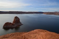
DSC_0489.JPGDSC_0490.JPG
 
This shoal/island surfaces 1100 feet off of Haystack Rock at the 3622-4 water level. It is scary. If you come downriver from the north and make a turn at Buoy 95 to head towards Bullfrog Marina you pass right over it. Has anyone grounded on this thing or known anyone who has?
 
Last edited:
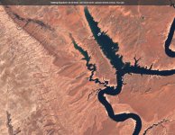
Here is the barely submerged hazard in question. You can see it sticking out prominently at the mouth of Bullfrog bay. Looks like cutting across the mouth of the bay is no longer a wise option, unless of course you want to chill out on the rocks a bit. The image was pulled from the following site: Sentinel-hub EO-Browser3. Lots of great current satellite imagery here. You can just zoom in only so far.

2021-04-30-00_00_2021-04-30-23_59_Landsat_8_(USGS_archive)_True_color.jpg
 
Status
Not open for further replies.
Back
Top