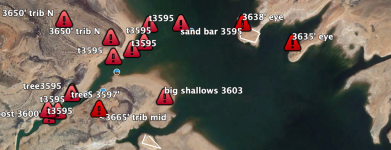
Halls Creek Whale

Status
Not open for further replies.
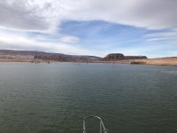
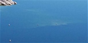
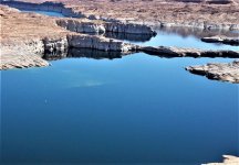
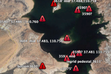
View attachment 11821
Just keep using the Navionics boating app. It shows clearly on the app when you set the water levels correctly along with your shallow water indicator. I have nearly hit the high point of this area a couple times when trying to cut the corner with a houseboat. It's a little spooky when you see the water color abruptly change, but at the same time I could tell there was plenty of clearance. We missed that troubles with lower water in 2019 since our boat was waiting for major pontoon repairs and it completely killed our summer house boating for the entire crew.
The newer charts are great. I've run Navionics and Lake Master side by side for the last several years. They are both good, but neither one is perfect, they both have misses that can ruin a trip and be expensive. These pictures and others experiences are invaluable to share.
 
Last edited:
Man, I had the same thought. Antelope opened in, what, ‘06? Maybe a few went to antelope, and some picked up spots at Wahweap as boats there went to Antelope.
We have watched the buoy field at Halls slowly decrease in number over the past 10 years. I think many of the boats that were on buoys were older and have been retired. Additionally, Bullfrog has expanded their slip capacity pretty significantly and are opening a whole bunch of additional slips this summer.

The newer charts are great. I've run Navionics and Lake Master side by side for the last several years. They are both good, but neither one is perfect, they both have misses that can ruin a trip and be expensive. These pictures and others experiences are invaluable to share.
I agree. Nothing like the experience of the group on this forum to help identify trouble spots. I wouldn't have even thought about the need for paying attention to the charts as you come out of Bullfrog Bay until I saw the thread in 2019.
 
most the tops of the cottonwoods on the west side tributaries of Halls sit at about 3608' and below. There one right at the mouth of the trib across from the Eye that few people notice.
 
Man, I had the same thought. Antelope opened in, what, ‘06? Maybe a few went to antelope, and some picked up spots at Wahweap as boats there went to Antelope.
A lot of the older boats in the Hall’s buoy field lost insurance in the last couple of years. We were able to maintain insurance on the condition we moved to a slip. Aramark also pulled a number of the buoy’s, which may have forced boats to Bullfrog, or to land based storage
 
Years ago there was a group of us that about 4 boats when we would go in the spring on fishing camping trips up the Juan . We all would save our milk jugs from home and buy a roll of Masonry twine . We would mark the hazards as we saw them and add some extra twine so when the lake rose up they would be seen . Saved our bacon and others lower units as well . If we all did it , we would be making a safer trip for all of us . Maybe the NPS would wake up and participate . We would pick them up after the lake would rise and find them in coves and picked up other people's trash at the same time . We would also put a date on the jug . Probably illegal to do . But it saved some long tow trips and saved some fishing trips. Tuft lines brothers . Biffers
 
Well let's all do it . And make spring time fishing safer and if we all put our names on it we could post it and talk about fishing tips in that area at that time . And help pick them up when the lake rises and share where they were found . Was in Bullfrog bay this morning . 4" double tail jigs in green with a brown skirt and a chartruse 1/4 oz wide gap lead jig head on 6 # test in 15 foot of water off points we caught some fat bass late in the afternoon. Happy fishing everyone . It's going to be a dangerous year for buried treasures . Let's help each other . Bif
 
What do you use to weight the jugs? We have tried marking spots in the past, those just below the surface whales, but generally have a hard time getting them to stay in place
 
Status
Not open for further replies.
Back
Top