Wayne's Words Archive
Active Member
June 16, 2007 - Hikers: Mitch and Kevin Lanyon from Cahone, Colorado
Lake Elevation: 3,611.05
Temperature: 100 degrees
Hike distance: approx. 1.3 miles
Geologic Feature: Hall's Creek Bay Arch
I've also seen this one referred to as Baker Ranch Natural Bridge.

My son Mitch and I recently made the hike to Hall's Creek Bay Arch and wanted to share the details with your readers.
GPS N 37 30.058' W110 47.215'

This hike was a short one for me and I would consider it "mild". However, we hike a lot and we're in reasonably good shape. So, due to the heat, change in elevation and terrain, I'm going to err on the side of caution and call it moderate. As I said, this is a fairly short hike and well worth the effort. It took us about 4 hours but we stop a lot to check things out and take photos. Remember to take plenty of water!!!
This arch is very difficult to spot from the lake but it can be done depending on your vantage point and if you know right where to look. Come into Hall's Creek Bay and work your way to the far end. Look for a "finger" on the left that goes back in quite a way. If you have a GPS this will be a much easier task. The finger is just past a couple of huge rock structures right at water's edge. You should have no problem finding a spot to beach your boat.
Photo 2 shows the route that we took. There are no cairns but you won't need them. You're going to walk along the top edge of the drainage. The right side is the easiest. Stay out of the drainage. It's a total jungle in places and you'll eventually come to huge cliff. You won't be able to climb out and you'll have to back track to get out.

You won't need a rope but we always carry hiking sticks and find them very handy. Other normal hiking gear is recommended e.g. boots, hat that provides shade, a knife or leatherman tool etc. Also, be sure to let some folks know where you'll be in case you become injured or lost.

Photos 3, 4, 5 & 6
GPS N 37 29.776' W 110 47.715'

We took a short break here. We peaked into the drainage to check things out and found this beautiful water fall. I was surprised to see so much water in the middle of June. Make the effort to stop and find this spot. It's drop dead gorgeous and well worth it.

GPS N 37 29.633' W 110 48.283'

You're almost there at this point. Photo 7 shows a shot of Mitch up on the rim.

Photo 8 shows the cliff I spoke of and why you don't want to be down in the drainage. There is where you'd have to turn back if you were down in the bottom.

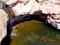
Photo 9 shows Mitch with a small diameter plunge pool. This one is more than 6 feet deep. Continue on staying on the edge of the drainage. You'll go up and around the corner and the arch will appear. You can't miss it.

Photos 10, 11 & 12
GPS N 37 29.587' W 110 48.495'
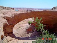
This is it! As you can see the arch is quite high and comes down to a beautiful plunge pool. You can hike up and get around to the back side. I'd suggest taking the left side but it's steep as well so be careful. There is no book or journal to sign your name. Some people carve up the rock. I'm not into that. Just tag this one in your personal journal and call it good. That's it. Have a great hike. Take your time and enjoy the sights along the way. It may look like a bunch of desolate rock but take a closer look and you'll be fascinated I guarantee it!!!


Lake Elevation: 3,611.05
Temperature: 100 degrees
Hike distance: approx. 1.3 miles
Geologic Feature: Hall's Creek Bay Arch
I've also seen this one referred to as Baker Ranch Natural Bridge.

My son Mitch and I recently made the hike to Hall's Creek Bay Arch and wanted to share the details with your readers.
GPS N 37 30.058' W110 47.215'

This hike was a short one for me and I would consider it "mild". However, we hike a lot and we're in reasonably good shape. So, due to the heat, change in elevation and terrain, I'm going to err on the side of caution and call it moderate. As I said, this is a fairly short hike and well worth the effort. It took us about 4 hours but we stop a lot to check things out and take photos. Remember to take plenty of water!!!
This arch is very difficult to spot from the lake but it can be done depending on your vantage point and if you know right where to look. Come into Hall's Creek Bay and work your way to the far end. Look for a "finger" on the left that goes back in quite a way. If you have a GPS this will be a much easier task. The finger is just past a couple of huge rock structures right at water's edge. You should have no problem finding a spot to beach your boat.
Photo 2 shows the route that we took. There are no cairns but you won't need them. You're going to walk along the top edge of the drainage. The right side is the easiest. Stay out of the drainage. It's a total jungle in places and you'll eventually come to huge cliff. You won't be able to climb out and you'll have to back track to get out.

You won't need a rope but we always carry hiking sticks and find them very handy. Other normal hiking gear is recommended e.g. boots, hat that provides shade, a knife or leatherman tool etc. Also, be sure to let some folks know where you'll be in case you become injured or lost.

Photos 3, 4, 5 & 6
GPS N 37 29.776' W 110 47.715'

We took a short break here. We peaked into the drainage to check things out and found this beautiful water fall. I was surprised to see so much water in the middle of June. Make the effort to stop and find this spot. It's drop dead gorgeous and well worth it.

GPS N 37 29.633' W 110 48.283'

You're almost there at this point. Photo 7 shows a shot of Mitch up on the rim.

Photo 8 shows the cliff I spoke of and why you don't want to be down in the drainage. There is where you'd have to turn back if you were down in the bottom.

Photo 9 shows Mitch with a small diameter plunge pool. This one is more than 6 feet deep. Continue on staying on the edge of the drainage. You'll go up and around the corner and the arch will appear. You can't miss it.

Photos 10, 11 & 12
GPS N 37 29.587' W 110 48.495'
This is it! As you can see the arch is quite high and comes down to a beautiful plunge pool. You can hike up and get around to the back side. I'd suggest taking the left side but it's steep as well so be careful. There is no book or journal to sign your name. Some people carve up the rock. I'm not into that. Just tag this one in your personal journal and call it good. That's it. Have a great hike. Take your time and enjoy the sights along the way. It may look like a bunch of desolate rock but take a closer look and you'll be fascinated I guarantee it!!!


