Ever Wonder Why It's Called Forgotten Canyon?

JFRCalifornia

Keeper of San Juan Secrets
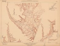
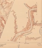
It's you've ever been to Defiance House Ruin, you've traveled up Forgotten Canyon. In spite of its name, it's got to be one of the more popular places to visit in the north end of Lake Powell. For such a popular destination, how did it get its name "Forgotten Canyon"? Well, for that you have to go back to the USGS river surveys of the early 1920s. When they came through Glen Canyon in 1921, what they left behind was a fantastic series of survey maps of the river, showing great detail with 20-foot contour intervals. They published these in 1922, and they ultimately proved useful for the future consideration of possible dam sites along the river. Although the USGS focused on the Colorado River itself in their survey work, they also mapped the portions of side canyons closest to the river. But somehow, they overlooked the canyon straight across from the mouth of Smith Fork. You can see it on this attached map (the second image is detail from the first map):
small - plate-I Smith Warm Sprngs 131 to 137.jpgplate-I Smith Warm Sprngs 131 to 137 - detail.jpg

Right there at Mile 132, there should be an entrance to a canyon, heading to the east. But there isn't. It had been overlooked. Forgotten.

In 1951, during a river trip down Glen Canyon, river runner Harry Aleson suggested calling it "No Name Canyon". But on that same trip, Dudy Thomas thought it would be better to call it Forgotten Canyon. They all agreed that was a better name. And so the name stuck.
 
I'm curious - do you have any knowledge of how surveyors were able to determine elevations of contours in 1921? Do they just eyeball it and estimate? Or are they actually walking across all those mountains and surveying the elevations?
 
I'm curious - do you have any knowledge of how surveyors were able to determine elevations of contours in 1921? Do they just eyeball it and estimate? Or are they actually walking across all those mountains and surveying the elevations?

You can read many details here:


Note the photo is actually the survey of Glen Canyon in 1921!

And here’s the actual USGS manual for doing surveys from 1901:


Most of which would be the same in 1921.

I believe stereographic aerial surveys would have been the next big change to topographical measurement methods.

EDIT: Sorry, didn’t answer your specific question! They did “eyeball” or sketch details between a network of surveyed points up until the 1930s. So the map is based on a skeleton of accurate measurements then connected “by eye”. Once they had aerial stereo photography they could connect those surveyed points with much higher fidelity.
 
Last edited:
And here’s the actual USGS manual for doing surveys from 1901:


Most of which would be the same in 1921.

I believe stereographic aerial surveys would have been the next big change to topographical measurement methods.

EDIT: Sorry, didn’t answer your specific question! They did “eyeball” or sketch details between a network of surveyed points up until the 1930s. So the map is based on a skeleton of accurate measurements then connected “by eye”. Once they had aerial stereo photography they could connect those surveyed points with much higher fidelity.

Interesting manual. Thanks
 
I'm curious - do you have any knowledge of how surveyors were able to determine elevations of contours in 1921? Do they just eyeball it and estimate? Or are they actually walking across all those mountains and surveying the elevations?
John Wesley Powell's expeditions were collecting altitude readings of the river and surrounding terrain 50 years prior with nothing but barometers, sextants, stars, and math (until they broke all their equipment, that is)

Not as detailed as this survey but the methods have existed for a long time.
 
Back
Top