FishnFly
Well-Known Member
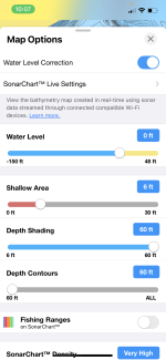
Just downloaded Navionics on my iPhone. Was playing around with it, specifically at the Fishing Ranges and Water Level settings. It appears there is no way to plug in a current elevation number (3524). Instead you have to do some math to come up with a specific number of feet lower or higher than 0.Yep screenshot from phone navionics. It’s not an exact science as that shelf ran from about 12 feet to 26 feet at that time with different humps and stuff not shown on the map. So don’t just pull up trusting it 100%. Even on better mapped lakes I’ve pulled up on “12 foot ledges” and they’ve been sand bars sticking out of the water. So use some discretion when pulling up on these shallow flats.
My question is, what lake level at Lake Powell on Navionics is considered 0 (the elevation starting point to measure from). If it’s full pool of 3700 then the slider allows one to adjust downward by 150 feet but we are currently 175’ish feet lower than full pool of 3700.
I actually called Navionics and they were unable to give me a direct answer about this dilemma. They told me that each lakes elevation is based off of full pool Elevation.
Any advice on this from anyone would be very helpful. I know this thing is not 100% accurate but I would hope I could get it closer than the 25 foot offset I think I have if 0 is based on 3700MSL elevation with a lake level of 3525msl.