
You are using an out of date browser. It may not display this or other websites correctly.
You should upgrade or use an alternative browser.
You should upgrade or use an alternative browser.
Bullfrog and Hite Low Water Ramps
- Thread starter Ryan
- Start date


RobertGosselin
Well-Known Member
Stanton Creek has been proposed as the site for the new permanent ramp at Bullfrog in the past. I haven't seen any new proposals.I wonder where this ramp at Bullfrog is to be located? It makes sense that they will utilize the old public ramp to help a
facilitate this. The road maybe meaning from the end of that ramp to new concrete one. Primitive is what the existing ramp is called.
Thanks Ryan.


Trix
Keeper of San Juan Secrets
I hate to rake business away from JFR, but GPT has this take on about 50 feet NEXT year.
If you mean what 2027 water-year unregulated inflow would be needed to raise Lake Powell from the projected end-of-2026 level to about 3,560 feet by the end of 2027, the answer is roughly 12 million acre-feet (MAF).
Here’s the calculation:
**4.52 MAF needed for elevation gain
How unusual would that be?
Reclamation’s August 2026 forecast puts the 2027 most-probable inflow at only 7.30 MAF, or 76% of average. The maximum-probable scenario is 14.30 MAF (149% of average).
So ~11.6 MAF would be a very wet year—roughly 120% of the long-term average—but not unprecedented. It would be considerably wetter than the current forecast.
Interestingly, that means 3,560 ft is actually achievable with a substantially above-average 2027 runoff year, rather than requiring an extraordinary once-in-a-century event.
If you mean what 2027 water-year unregulated inflow would be needed to raise Lake Powell from the projected end-of-2026 level to about 3,560 feet by the end of 2027, the answer is roughly 12 million acre-feet (MAF).
Here’s the calculation:
- Reclamation’s current projection for September 30, 2026 is about 3,515.9 ft, with 5.03 MAF in storage.
- At 3,560 ft, the USGS 2018 elevation-storage curve shows about 9.55 MAF of storage.
- So the lake needs roughly 4.52 MAF of net additional storage.
- During 2027, however, water will be released downstream. Under the new 2027–28 operating guidelines, with Powell starting below 3,525 ft, the expected 2027 release is 6–7 MAF.
- Reservoir evaporation and other losses add roughly another 0.5–0.7 MAF.
**4.52 MAF needed for elevation gain
- 6.5 MAF release
- ~0.6 MAF evaporation/losses
= ~11.6 MAF inflow**
How unusual would that be?
Reclamation’s August 2026 forecast puts the 2027 most-probable inflow at only 7.30 MAF, or 76% of average. The maximum-probable scenario is 14.30 MAF (149% of average).
So ~11.6 MAF would be a very wet year—roughly 120% of the long-term average—but not unprecedented. It would be considerably wetter than the current forecast.
Interestingly, that means 3,560 ft is actually achievable with a substantially above-average 2027 runoff year, rather than requiring an extraordinary once-in-a-century event.

dallas massie
Escalante-Class Member
dallas massie
Escalante-Class Member
dallas massie
Escalante-Class Member
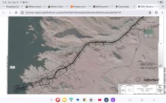
Hopefully somebody with better computer skills can post this better. The new ramp is in the main channel straight across from where the ferry is parked. The marina is never going back to where it was , it will be moved to this ramp , project is 14 months long , has not started.
Attachments
Last edited:
dallas massie
Escalante-Class Member


Makes me think thats in their master plan!!!! Which has been in my head for years.If they are planning the Stanton Creek site for the new marina/launch ramp area, has someone already decided that the lake will never get another 50’+ of elevation? Sq
dallas massie
Escalante-Class Member
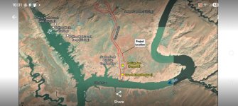

I recall seeing somewhere that the contractor for the project won’t be selected until Dec 2026. That plus 14 month project, plus contractors time to schedule the project once they have a contact—-we are definitely looking at mid 2028 at best
I find one of the sentences in their announcement to be troubling. What type of "unauthorized shoreline use" are they trying to stop in this Recreation Area in the name of "reducing resource impacts"? The only one that comes to mind is driving on land to the water's edge which is or was authorized. In all of my years enjoying the resource, I'm not aware of or seen any use by the public that would cause any lasting impact to the shoreline. What other uses are of such a concern that they need to be stopped? Wouldn't a sign, like they tried at the Blue Notch a few years ago, be more cost effective than a new road and ramp?
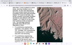
What exactly are they proposing up at Hite? Are they talking about the, already primitive, Glencove aka North Wash access or the left bank where the concrete ramp is situated? There is so much sediment deposited in that area and the river is carving down through it at a rate of 8-10 feet each year. How do you plan for that? Just upstream from the Glencove ramp there are rocks appearing and rapids forming because the river is so far out of its original channel and is now exposing the bedrock.
On the other side the huge concrete ramp descends to ~3650 and for good reason. There are two substantial 'cliffs' between the end of the ramp and the historic river channel, elevation ~3460, all now infilled with sediment. There is no way you could provide reliable access on that left bank.
In short, I'm not sure NPS can do anything to improve river/reservoir access in the Hite area. Apart from pray for snow, I suppose.
I realize all this but in 2022 they sent out the same plans but never did anything, So is there hope that this statement means they will get started on Stanton Creek? Last I heard they would not start until after the first of the year.That's why I thought this might be improvements to existing "primitive ramp".

JFRCalifornia
Keeper of San Juan Secrets
Here's the plan for Hite, from the NEPA document prepared to address this project...What exactly are they proposing up at Hite? Are they talking about the, already primitive, Glencove aka North Wash access or the left bank where the concrete ramp is situated? There is so much sediment deposited in that area and the river is carving down through it at a rate of 8-10 feet each year. How do you plan for that? Just upstream from the Glencove ramp there are rocks appearing and rapids forming because the river is so far out of its original channel and is now exposing the bedrock.
On the other side the huge concrete ramp descends to ~3650 and for good reason. There are two substantial 'cliffs' between the end of the ramp and the historic river channel, elevation ~3460, all now infilled with sediment. There is no way you could provide reliable access on that left bank.
In short, I'm not sure NPS can do anything to improve river/reservoir access in the Hite area. Apart from pray for snow, I suppose.
******
Overview
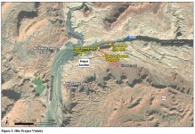
The new ramp would be upstream of the Dirty Devil River, the existing Hite ramp, and the North Wash takeout near the SR 95 bridge on the south side of the river (Figure 3). The proposed action would include improving the existing dirt road, constructing upper and lower parking areas, and constructing a primitive fixed launch/retrieval ramp as described as follows. No utilities or other amenities are included at this location.
Staging and stockpiling would take place within the parking areas and other previously disturbed areas inside the project footprint, avoiding environmentally sensitive areas. Temporary fencing would be installed before construction. Areas not required for ongoing operation of the launch ramp and access road would be reclaimed and returned to their pre-construction contours following completion of construction. During construction, BMPs would be used along the road and ramp to minimize erosion and sedimentation. Surplus rock and gravel material would be incorporated in site construction to the extent possible and graded to promote proper drainage. Construction at Hite is expected to take approximately 21 months to complete. Construction will be continuous once started and will take place during daylight hours. Air quality requirements described for Bullfrog would also be applicable to Hite.
Access Road
The proposed access road would improve and extend an existing primitive road from its intersection with the Hite Marina Road for approximately 0.5 mile. Beyond the existing road, a new road would be constructed for 0.8 mile to reach the river. The road would be approximately 18 feet wide, and although primarily designed for one-way traffic, the width would allow two vehicles to pass at the same time. The two parking areas included along the road can be used to accommodate the passage of wider truck and trailer combinations.
Extension of the road would include grading, vegetation removal, and drainage improvements. Stormwater flowing beneath the roadway would be directed through reinforced concrete pipes or box culverts, maintaining existing flow patterns. The pipes and box culverts would be designed to handle different volumes of water depending on the specific needs of the area. No paving is included for the Hite access road, which will be composed of rock and gravel from construction. Blasting to remove rock may be required along portions of the road to achieve the desired alignment and grade.
Parking Areas
Two parking areas are proposed at the new Hite ramp: an upper parking area of approximately 5.25 acres and a lower parking area of approximately 0.7 acre. Both would accommodate boat trailers and trucks/passenger vehicles. Construction of the parking areas would involve clearing vegetation and leveling the ground/adding fill to achieve the desired contour and grade. The gravel parking areas would be constructed from the surplus rock and gravel generated onsite through blasting and cutting for the ramp construction to the maximum extent practical. Parking areas would be outside of the ordinary high water mark.
Launch Ramp
The new 1,025-foot-long launch ramp would be approximately 35 feet wide and constructed on a 16 percent grade. Ramp construction would require blasting or excavation of cut areas, followed by installation of precast planks for in-water work, cast-in-place concrete sections for out of water work and cast-in-place concrete planks in the water to create the ramp surface. In-water work may include grading, blasting, dredging, installing a turbidity curtain, creating a cofferdam, placing gravel, dewatering, and installing concrete planks. The parking areas and launch ramp may also be used for materials processing during construction, including crushing rock for road fill and surfacing aggregate. The proposed project is estimated to require removal of approximately 250,000 cubic yards of rock via blasting to facilitate adequate ramp grade to the water. Sediment would be disposed of at a location identified during final design and not used in construction. The new launch ramp would include broadcasted weather warnings and instructional signage at for ramp users.
JFRCalifornia
Keeper of San Juan Secrets
Yes indeed, ChatGPT can be your friend. And those numbers are accurate. It certainly seems reasonable to achieve an unregulated flow of 11-12 maf, since it's happened many times before. That said, the average unregulated inflow from 2000-2025 is about 8.4 maf. A better figure to look at is the "natural flow" of the river system, which USGS tracks. That's the total flow of the river before any diversions are considered, including any use by the upper basin. The average natural flow of the river since Powell was formed in 1963 is about 13.8 maf. Since 2000, it's about 12.2 maf. Since 2018, it's 11.1 maf.I hate to rake business away from JFR, but GPT has this take on about 50 feet NEXT year.
If you mean what 2027 water-year unregulated inflow would be needed to raise Lake Powell from the projected end-of-2026 level to about 3,560 feet by the end of 2027, the answer is roughly 12 million acre-feet (MAF).
Here’s the calculation:
So, approximately:
- Reclamation’s current projection for September 30, 2026 is about 3,515.9 ft, with 5.03 MAF in storage.
- At 3,560 ft, the USGS 2018 elevation-storage curve shows about 9.55 MAF of storage.
- So the lake needs roughly 4.52 MAF of net additional storage.
- During 2027, however, water will be released downstream. Under the new 2027–28 operating guidelines, with Powell starting below 3,525 ft, the expected 2027 release is 6–7 MAF.
- Reservoir evaporation and other losses add roughly another 0.5–0.7 MAF.
**4.52 MAF needed for elevation gain
I’d therefore use about 11.5–12 MAF of unregulated inflow in WY2027 as the ballpark needed to finish 2027 near 3,560 ft.
- 6.5 MAF release
- ~0.6 MAF evaporation/losses
= ~11.6 MAF inflow**
How unusual would that be?
Reclamation’s August 2026 forecast puts the 2027 most-probable inflow at only 7.30 MAF, or 76% of average. The maximum-probable scenario is 14.30 MAF (149% of average).
So ~11.6 MAF would be a very wet year—roughly 120% of the long-term average—but not unprecedented. It would be considerably wetter than the current forecast.
Interestingly, that means 3,560 ft is actually achievable with a substantially above-average 2027 runoff year, rather than requiring an extraordinary once-in-a-century event.
Whichever of those figures you start with, lop off about 4-4.5 maf for upper basin use, and then maybe another 0.5-1.0 for losses from evaporation and seepage. If you're using the 1963-2025 average, that brings you down to an average of about 8.3-9.3 maf available for storage in Powell or the upper reservoirs... less 6-7 maf through GCD, and you've got a net of 2-3 maf or so in Lake Powell. But if you use the 2000-25 average natural flow of 12.2 maf, an average runoff year nets you less than 2 maf for new storage in Powell. Once the lake hits its low in March, a 2 maf rise would bring the lake from its low around 3510 to about 3545.
It's gonna take a well-above average runoff to get us to 3560. Could happen, hope it does.
So yeah, I agree with ChatGPT. I guess I can retire now.
Last edited:
Trix
Keeper of San Juan Secrets
Don’t you dare.I guess I can retire now
Nice one, JFR. That is quite interesting.Here's the plan for Hite, from the NEPA document prepared to address this project...
******
Overview
The new ramp would be upstream of the Dirty Devil River, the existing Hite ramp, and the North Wash takeout near the SR 95 bridge on the south side of the river (Figure 3). The proposed action would include improving the existing dirt road, constructing upper and lower parking areas, and constructing a primitive fixed launch/retrieval ramp as described as follows. No utilities or other amenities are included at this location.
Staging and stockpiling would take place within the parking areas and other previously disturbed areas inside the project footprint, avoiding environmentally sensitive areas. Temporary fencing would be installed before construction. Areas not required for ongoing operation of the launch ramp and access road would be reclaimed and returned to their pre-construction contours following completion of construction. During construction, BMPs would be used along the road and ramp to minimize erosion and sedimentation. Surplus rock and gravel material would be incorporated in site construction to the extent possible and graded to promote proper drainage. Construction at Hite is expected to take approximately 21 months to complete. Construction will be continuous once started and will take place during daylight hours. Air quality requirements described for Bullfrog would also be applicable to Hite.
Access Road
The proposed access road would improve and extend an existing primitive road from its intersection with the Hite Marina Road for approximately 0.5 mile. Beyond the existing road, a new road would be constructed for 0.8 mile to reach the river. The road would be approximately 18 feet wide, and although primarily designed for one-way traffic, the width would allow two vehicles to pass at the same time. The two parking areas included along the road can be used to accommodate the passage of wider truck and trailer combinations.
Extension of the road would include grading, vegetation removal, and drainage improvements. Stormwater flowing beneath the roadway would be directed through reinforced concrete pipes or box culverts, maintaining existing flow patterns. The pipes and box culverts would be designed to handle different volumes of water depending on the specific needs of the area. No paving is included for the Hite access road, which will be composed of rock and gravel from construction. Blasting to remove rock may be required along portions of the road to achieve the desired alignment and grade.
Parking Areas
Two parking areas are proposed at the new Hite ramp: an upper parking area of approximately 5.25 acres and a lower parking area of approximately 0.7 acre. Both would accommodate boat trailers and trucks/passenger vehicles. Construction of the parking areas would involve clearing vegetation and leveling the ground/adding fill to achieve the desired contour and grade. The gravel parking areas would be constructed from the surplus rock and gravel generated onsite through blasting and cutting for the ramp construction to the maximum extent practical. Parking areas would be outside of the ordinary high water mark.
Launch Ramp
The new 1,025-foot-long launch ramp would be approximately 35 feet wide and constructed on a 16 percent grade. Ramp construction would require blasting or excavation of cut areas, followed by installation of precast planks for in-water work, cast-in-place concrete sections for out of water work and cast-in-place concrete planks in the water to create the ramp surface. In-water work may include grading, blasting, dredging, installing a turbidity curtain, creating a cofferdam, placing gravel, dewatering, and installing concrete planks. The parking areas and launch ramp may also be used for materials processing during construction, including crushing rock for road fill and surfacing aggregate. The proposed project is estimated to require removal of approximately 250,000 cubic yards of rock via blasting to facilitate adequate ramp grade to the water. Sediment would be disposed of at a location identified during final design and not used in construction. The new launch ramp would include broadcasted weather warnings and instructional signage at for ramp users.
View attachment 36552
Yeah, have a little lie down until next April. We'll cope somehow.Yes indeed, ChatGPT can be your friend. And those numbers are accurate. It certainly seems reasonable to achieve an unregulated flow of 11-12 maf, since it's happened many times before. That said, the average unregulated inflow from 2000-2025 is about 8.4 maf. A better figure to look at is the "natural flow" of the river system, which USGS tracks. That's the total flow of the river before any diversions are considered, including any use by the upper basin. The average natural flow of the river since Powell was formed in 1963 is about 13.8 maf. Since 2000, it's about 12.2 maf. Since 2018, it's 11.1 maf.
Whichever of those figures you start with, lop off about 4-4.5 maf for upper basin use, and then maybe another 0.5-1.0 for losses from evaporation and seepage. If you're using the 1963-2025 average, that brings you down to an average of about 8.3-9.3 maf available for storage in Powell or the upper reservoirs... less 6-7 maf through GCD, and you've got a net of 2-3 maf or so in Lake Powell. But if you use the 2000-25 average natural flow of 12.2 maf, an average runoff year nets you less than 2 maf for new storage in Powell. Once the lake hits its low in March, a 2 maf rise would bring the lake from its low around 3510 to about 3545.
It's gonna take a well-above average runoff to get us to 3560. Could happen, hope it does.
So yeah, I agree with ChatGPT. I guess I can retire now.