The New Water Year 2025-2026

flowerbug

Escalante-Class Member
It has been interesting so far that is for sure and with the recent storm mostly going north it reminds me of how much can change just from one good hit from the Pineapple Express.

I'm waiting to see how much of an impact this storm has on inflow amounts. Hoping for a bunch!

I like to keep the totals in mind when looking at the system as whole, here are the current upstream reservoir total as kept by the water database nice people: :)

List Totals2025-10-2510,344,6407,215,54869.75 %


And then these two biggies:

Lake Powell is 28% of Full Pool (24,322,000 af)
Lake Mead is 31.88% of Full Pool (25,877,000 af)


They are currently draining Lake Mead more than Lake Powell.

Powell water storage has risen by 62,384 AF and total inflows have exceeded total outflows by 82,741 AF

Lake Mead water storage has fallen by 462,686 AF


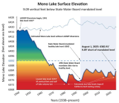
I also keep an eye on how California water reservoirs are doing along with the Tulare basin, Mono Lake, Owens Lake and the Salton Sea. Plus the Great Salt Lake is interesting too so I'm usually checking that out from time to time.
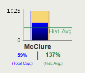
Just in case you didn't know, here is a dashboard of California Reservoirs: Major Water Supply Reservoirs

They are all around their historical averages.

You mentioned Owens Lake, and I thought that was just a dry lake. And it mostly is. But apparently there is also an Owens Reservoir on the other side of the Sierra Nevada range. That one is also basically empty right now. I guess that is managed by the US Army Corps of Engineers, so isn't on the California dashboard I posted. It's here: Water Data - U.S. Army Corps of Engineers
 
Just in case you didn't know, here is a dashboard of California Reservoirs: Major Water Supply Reservoirs

Yes, i've got that one bookmarked and have been following it. Since it is not really directly related to Lake Powell or the Colorado River basin I didn't inlcude it here.


They are all around their historical averages.

You mentioned Owens Lake, and I thought that was just a dry lake. And it mostly is. But apparently there is also an Owens Reservoir on the other side of the Sierra Nevada range. That one is also basically empty right now. I guess that is managed by the US Army Corps of Engineers, so isn't on the California dashboard I posted. It's here: Water Data - U.S. Army Corps of Engineers

I follow Owens Lake because it is similar to The Salton Sea and The Great Salt Lake and Lake Owens (all lakes which have no exit flows so they accumulate salts) and it is one of the worst disasters in California which has cost a lot of $ so far to moderate the emissions of dust (which is what it would be like for The Salton Sea or The Great Salt Lake). None of them are easy to deal with but even worse to ignore.
 
I concur. Drove along the north side of Mono Lake, through Lee Vining, Yosemite, Lake McClure/Lake McSwain (McSwain is a forebay) and back via Tonopah/Rachel,NV a few weeks ago. Not surprisingly, very low water levels / very high human population drawing on the resources.

[As an aside, the longest single straight-as-a-die stretch of highway I have thus far travelled in western States is CA167 along the north shore of Mono Lake (approx. 20 mile stretch and one can see its entire length, virtually). Beautiful and fun!]
 
Yes, i've got that one bookmarked and have been following it. Since it is not really directly related to Lake Powell or the Colorado River basin I didn't inlcude it here.


I follow Owens Lake because it is similar to The Salton Sea and The Great Salt Lake and Lake Owens (all lakes which have no exit flows so they accumulate salts) and it is one of the worst disasters in California which has cost a lot of $ so far to moderate the emissions of dust (which is what it would be like for The Salton Sea or The Great Salt Lake). None of them are easy to deal with but even worse to ignore.
I own property that abuts the GSL shoreline.
It is sad to not even be able to see the water anymore.
 
I concur. Drove along the north side of Mono Lake, through Lee Vining, Yosemite, Lake McClure/Lake McSwain (McSwain is a forebay) and back via Tonopah/Rachel,NV a few weeks ago. Not surprisingly, very low water levels / very high human population drawing on the resources.

[As an aside, the longest single straight-as-a-die stretch of highway I have thus far travelled in western States is CA167 along the north shore of Mono Lake (approx. 20 mile stretch and one can see its entire length, virtually). Beautiful and fun!]
Conversely, the south shore of Mono Lake has perhaps the most fun road I have ever driven, CA120, which is an absolute roller coaster of a road.
Mono Mills, CA - Roller Coaster Road
 
Conversely, the south shore of Mono Lake has perhaps the most fun road I have ever driven, CA120, which is an absolute roller coaster of a road.
Mono Mills, CA - Roller Coaster Road
Yes. I drove the full loop around Mono Lake about 10 years ago in my Jeep. The south side was challenging especially due to about 2 miles of diagonal ridges which cause a side-to-side violent rocking. Have you ever seen the delicate sand tufa on the south side?
 
Yes. I drove the full loop around Mono Lake about 10 years ago in my Jeep. The south side was challenging especially due to about 2 miles of diagonal ridges which cause a side-to-side violent rocking. Have you ever seen the delicate sand tufa on the south side?
Whoops, wrong road. I was on the dirt road that encircles Mono Lake.
 
I own property that abuts the GSL shoreline.
It is sad to not even be able to see the water anymore.

I didn't know that anyone could even do that there! Amazing! Sorry about the poor situation recently. How did it go a while back when the water level was really high and they put those pumps in?
 
Back
Top