
You are using an out of date browser. It may not display this or other websites correctly.
You should upgrade or use an alternative browser.
You should upgrade or use an alternative browser.
Lake Powell - Photos from the Early Years
- Thread starter JFRCalifornia
- Start date


JFRCalifornia
Keeper of San Juan Secrets
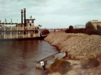
Here's a rare shot of Lake Powell on the rise in May 1964, just as it's reached the mouth of Forgotten Canyon...

JFRCalifornia
Keeper of San Juan Secrets
Here's another perspective from another era. This is a 1966 shot of the brand new bridge over the Colorado River, with Highway 95 still unpaved leading up to the bridge from either end. It wouldn't be paved all the way from Hanksville to near Blanding until 1976.
Although you can't tell from the photo, it's worth noting that even as early as 1966, Lake Powell extended well upstream beyond the Colorado River bridge, even though the lake was only at at somewhere around 3540, or about 30 feet lower than today in 2025. That goes to show how much sediment has been deposited at the upper end of the lake since then...

Although you can't tell from the photo, it's worth noting that even as early as 1966, Lake Powell extended well upstream beyond the Colorado River bridge, even though the lake was only at at somewhere around 3540, or about 30 feet lower than today in 2025. That goes to show how much sediment has been deposited at the upper end of the lake since then...
Rainbowbridge
Keeper of San Juan Secrets
Great find, & great Pic. While I SO love our Lake, seeing the inevitable encroaching 'inundation'...... you can kinda feel what Katie Lee and the other early river runners felt.....Here's a rare shot of Lake Powell on the rise in May 1964, just as it's reached the mouth of Forgotten Canyon...
View attachment 31342

JFRCalifornia
Keeper of San Juan Secrets
This is one of the oldest known photos of a boat on Lake Powell, taken in spring 1963. This remarkable shot just upstream of the dam appeared in the July 1963 issue of Desert Magazine. Although the resolution is poor, it's possible to see the outlet structures through the dam, which the lake had not yet reached. You can also see the dam is still unfinished at the top; the last of the concrete wouldn’t be poured until September 1963.
Best guess is that the lake at this point is no more than 100-150 feet deep at the base of the dam. It needs to be about 240 feet deep to reach "dead pool", and then about 360 feet deep to produce power, a depth the lake did not reach until August 1965. When full, it is about 570 feet deep... Although early Bureau estimates projected the lake would fill by 1970, it took another 10 years to reach that milestone...

Best guess is that the lake at this point is no more than 100-150 feet deep at the base of the dam. It needs to be about 240 feet deep to reach "dead pool", and then about 360 feet deep to produce power, a depth the lake did not reach until August 1965. When full, it is about 570 feet deep... Although early Bureau estimates projected the lake would fill by 1970, it took another 10 years to reach that milestone...
Last edited:
Jan Hertzen
Well-Known Member
You can still see the cofferdam stretching from wall-to-wall. And look at the dust in the air. Don't get too close or they'll start shooting arrows from the turrets!This is one of the oldest known photos of a boat on Lake Powell, taken in spring 1963. This remarkable shot just upstream of the dam appeared in the July 1963 issue of Desert Magazine. Although the resolution is poor, it's possible to see the outlet structures through the dam, which the lake had not yet reached. You can also see the dam is still unfinished at the top; the last of the concrete wouldn’t be poured until September 1963.
Best guess is that the lake at this point is no more than 100-150 feet deep at the base of the dam. It needs to be about 240 feet deep to reach "dead pool", and then about 360 feet deep to produce power, a depth the lake did not reach until August 1965. When full, it is about 570 feet deep... Although early Bureau estimates projected the lake would fill by 1970, it took another 10 years to reach that milestone...
View attachment 31772
Rainbowbridge
Keeper of San Juan Secrets
Great pic, JFR....and those are some brave folks. An inboard & wooden hull......with no depth finder......could be very unforgiving..... 
Marina Bum
Escalante-Class Member
cool photo but I had to look twice, could gave almost been some of us out there in 2022
Last edited:
Rainbowbridge
Keeper of San Juan Secrets
So JFR, in spring '63, there was no Wahweap, and these intrepid souls would have launched at Kane Creek and boated through what we now call the narrows past Antelope point to get to the dam? Is that about right?This is one of the oldest known photos of a boat on Lake Powell, taken in spring 1963. This remarkable shot just upstream of the dam appeared in the July 1963 issue of Desert Magazine. Although the resolution is poor, it's possible to see the outlet structures through the dam, which the lake had not yet reached. You can also see the dam is still unfinished at the top; the last of the concrete wouldn’t be poured until September 1963.
Best guess is that the lake at this point is no more than 100-150 feet deep at the base of the dam. It needs to be about 240 feet deep to reach "dead pool", and then about 360 feet deep to produce power, a depth the lake did not reach until August 1965. When full, it is about 570 feet deep... Although early Bureau estimates projected the lake would fill by 1970, it took another 10 years to reach that milestone...
View attachment 31772

Cuz you be our Lake Powell Wikipedia....
") ......when did the wahweap marina & launch ramp open?
......when did the wahweap marina & launch ramp open? Thanks!
")
JFRCalifornia
Keeper of San Juan Secrets
Great question.So JFR, in spring '63, there was no Wahweap, and these intrepid souls would have launched at Kane Creek and boated through what we now call the narrows past Antelope point to get to the dam? Is that about right?
Cuz you be our Lake Powell Wikipedia....
Thanks!
Well, here's an excerpt from the July 1963 article in Desert magazine that sheds some light on all this. Seems they had already constructed a temporary launch ramp at Wahweap by then (!), so I guess that was the way to get on the lake. Keep in mind that at the time the article was written the lake probably had not yet reached Kane Creek, so a boat launch there intended to access the lake would not have been possible, except as a short river trip ending up in the lake. Notably, there is no mention of Kane Creek in the article, either as a temporary or permanent launch site. They were probably trying to discourage folks from trying to use that road, since its days were numbered... At the same time, they were wildly overoptimistic that a launch site at Castle Butte (!) would be possible by the time the article appeared. The lake would not reach Castle Butte until 1964.
See the attached map in the article describing possible future launch and access locations.
Here's the excerpt from the article, full of interesting details, including some things that never happened:
With headquarters at Wahweap, seven miles from Page, Superintendent James Eden and his able staff of the National Park Service are doing a superior job, considering the many unknown factors such as estimating how rapidly the water will rise and to what height at a given time.
"Public desire and demand for immediate development and expansion of recreational facilities to permit beneficial use of the maximum amount of Lake Powell's 186 miles of length is a real force," Mr. Eden explained.
"To meet this obligation, the National Park Service has planned for access, facilities, and services on the lakeshore at seven widely spaced locations: Wahweap, Warm Creek, Hole-in-the-Rock, Oil Seep Bar, Hall's Crossing, and Hite. In addition, floating docks and other public-use installations will be provided at the Rainbow Bridge landing, where visitors may disembark for the relatively short hike to Rainbow Bridge. Accessible now only by a combination of boat and hiking travel or a long horseback ride, this world famous natural attraction will receive vastly increased visitation as the filling of Lake Powell makes convenient travel by boat a reality."
It is estimated that $16,000,000 will be spent during the next 10 years for the development of government facilities in the area. This does not include hundreds of thousands of dollars which will be spent by concessions for the development of the marinas at the six boat landings mentioned by Mr. Eden.
For a lake which will eventually stretch 186 miles—with 1800 miles of shoreline—six major boating facilities, plus smaller emergency areas, does not seem many. The problem, officials explain, is getting to the launching sites by road. The Colorado canyonlands is one of the most rugged areas in the world. It is a land of sawcut canyons, towers, buttes, spires, sheer cliffs and domes carved from colorful sandstone formations by the forces of erosion through centuries of time. Anyone who visits the area will return, for it is breathtakingly beautiful. But for engineers it is not conducive to the building of roads. Hence, the relatively small number of launching sites.
As this article appears, temporary boat launching facilities are available on the north shore at Wahweap, seven miles from Page, Arizona, site of the Glen Canyon Dam. Art Greene, veteran river-runner and owner of Glen Canyon Tours, Inc., which will operate the Wahweap concession, has built a floating boat landing which will gradually move as the lake fills until it reaches an area where he is building a permanent marina, to be one of the largest in the Southwest. He recently completed a new motel overlooking the lake site and a restaurant and lounge to be leased by well-known restauranteur Whit Parry, who also operates Parry Lodge in Kanab. Overnight accommodations are also available at Page.
Public camping grounds, parking areas, picnic areas and other facilities for visitors and campers are available at Wahweap through the National Park Service. These will increase as other areas develop.
It is possible that Castle Butte boating site, 147 miles upstream from the dam, may be in operation when this article appears. When water reaches this point it will have covered Hite, former site for launching river boats. For information relative to this area, contact the National Park Service, Glen Canyon National Recreation Area, Page, Arizona, or the professional guides listed in that area.
As stated before, professional guides will continue to arrange river-runs in this area for the final year during the summer of 1963.

Last edited:
Rainbowbridge
Keeper of San Juan Secrets
fascinating history.....As always, we wordlings are indeed indebted to you....Great question.
Well, here's an excerpt from the July 1963 article in Desert magazine that sheds some light on all this. Seems they had already constructed a temporary launch ramp at Wahweap by then (!), so I guess that was the way to get on the lake. Keep in mind that at the time the article was written the lake probably had not yet reached Kane Creek, so a boat launch there would not have been possible, except as a short river trip ending up in the lake. Notably, there is no mention of Kane Creek in the article, either as a temporary or permanent launch site. They were probably trying to discourage folks from trying to use that road, since its days were numbered... At the same time, they were wildly overoptimistic that a launch site at Castle Butte (!) would be possible by the time the article appeared. The lake would not reach Castle Butte until 1964.
See the attached map in the article describing possible future launch and access locations.
Here's the excerpt from the article, full of interesting details, including some things that never happened:
With headquarters at Wahweap, seven miles from Page, Superintendent James Eden and his able staff of the National Park Service are doing a superior job, considering the many unknown factors such as estimating how rapidly the water will rise and to what height at a given time.
"Public desire and demand for immediate development and expansion of recreational facilities to permit beneficial use of the maximum amount of Lake Powell's 186 miles of length is a real force," Mr. Eden explained.
"To meet this obligation, the National Park Service has planned for access, facilities, and services on the lakeshore at seven widely spaced locations: Wahweap, Warm Creek, Hole-in-the-Rock, Oil Seep Bar, Hall's Crossing, and Hite. In addition, floating docks and other public-use installations will be provided at the Rainbow Bridge landing, where visitors may disembark for the relatively short hike to Rainbow Bridge. Accessible now only by a combination of boat and hiking travel or a long horseback ride, this world famous natural attraction will receive vastly increased visitation as the filling of Lake Powell makes convenient travel by boat a reality."
It is estimated that $16,000,000 will be spent during the next 10 years for the development of government facilities in the area. This does not include hundreds of thousands of dollars which will be spent by concessions for the development of the marinas at the six boat landings mentioned by Mr. Eden.
For a lake which will eventually stretch 186 miles—with 1800 miles of shoreline—six major boating facilities, plus smaller emergency areas, does not seem many. The problem, officials explain, is getting to the launching sites by road. The Colorado canyonlands is one of the most rugged areas in the world. It is a land of sawcut canyons, towers, buttes, spires, sheer cliffs and domes carved from colorful sandstone formations by the forces of erosion through centuries of time. Anyone who visits the area will return, for it is breathtakingly beautiful. But for engineers it is not conducive to the building of roads. Hence, the relatively small number of launching sites.
As this article appears, temporary boat launching facilities are available on the north shore at Wahweap, seven miles from Page, Arizona, site of the Glen Canyon Dam. Art Greene, veteran river-runner and owner of Glen Canyon Tours, Inc., which will operate the Wahweap concession, has built a floating boat landing which will gradually move as the lake fills until it reaches an area where he is building a permanent marina, to be one of the largest in the Southwest. He recently completed a new motel overlooking the lake site and a restaurant and lounge to be leased by well-known restauranteur Whit Parry, who also operates Parry Lodge in Kanab. Overnight accommodations are also available at Page.
Public camping grounds, parking areas, picnic areas and other facilities for visitors and campers are available at Wahweap through the National Park Service. These will increase as other areas develop.
It is possible that Castle Butte boating site, 147 miles upstream from the dam, may be in operation when this article appears. When water reaches this point it will have covered Hite, former site for launching river boats. For information relative to this area, contact the National Park Service, Glen Canyon National Recreation Area, Page, Arizona, or the professional guides listed in that area.
As stated before, professional guides will continue to arrange river-runs in this area for the final year during the summer of 1963.
View attachment 31802
Jan Hertzen
Well-Known Member
Thanks for taking the time and effort to present this historical document to us, JFR. Those people had big plans for us. Now it seems they are indifferent to us and to the lake. It's very disappointing.Great question.
Well, here's an excerpt from the July 1963 article in Desert magazine that sheds some light on all this. Seems they had already constructed a temporary launch ramp at Wahweap by then (!), so I guess that was the way to get on the lake. Keep in mind that at the time the article was written the lake probably had not yet reached Kane Creek, so a boat launch there intended to access the lake would not have been possible, except as a short river trip ending up in the lake. Notably, there is no mention of Kane Creek in the article, either as a temporary or permanent launch site. They were probably trying to discourage folks from trying to use that road, since its days were numbered... At the same time, they were wildly overoptimistic that a launch site at Castle Butte (!) would be possible by the time the article appeared. The lake would not reach Castle Butte until 1964.
See the attached map in the article describing possible future launch and access locations.
Here's the excerpt from the article, full of interesting details, including some things that never happened:
With headquarters at Wahweap, seven miles from Page, Superintendent James Eden and his able staff of the National Park Service are doing a superior job, considering the many unknown factors such as estimating how rapidly the water will rise and to what height at a given time.
"Public desire and demand for immediate development and expansion of recreational facilities to permit beneficial use of the maximum amount of Lake Powell's 186 miles of length is a real force," Mr. Eden explained.
"To meet this obligation, the National Park Service has planned for access, facilities, and services on the lakeshore at seven widely spaced locations: Wahweap, Warm Creek, Hole-in-the-Rock, Oil Seep Bar, Hall's Crossing, and Hite. In addition, floating docks and other public-use installations will be provided at the Rainbow Bridge landing, where visitors may disembark for the relatively short hike to Rainbow Bridge. Accessible now only by a combination of boat and hiking travel or a long horseback ride, this world famous natural attraction will receive vastly increased visitation as the filling of Lake Powell makes convenient travel by boat a reality."
It is estimated that $16,000,000 will be spent during the next 10 years for the development of government facilities in the area. This does not include hundreds of thousands of dollars which will be spent by concessions for the development of the marinas at the six boat landings mentioned by Mr. Eden.
For a lake which will eventually stretch 186 miles—with 1800 miles of shoreline—six major boating facilities, plus smaller emergency areas, does not seem many. The problem, officials explain, is getting to the launching sites by road. The Colorado canyonlands is one of the most rugged areas in the world. It is a land of sawcut canyons, towers, buttes, spires, sheer cliffs and domes carved from colorful sandstone formations by the forces of erosion through centuries of time. Anyone who visits the area will return, for it is breathtakingly beautiful. But for engineers it is not conducive to the building of roads. Hence, the relatively small number of launching sites.
As this article appears, temporary boat launching facilities are available on the north shore at Wahweap, seven miles from Page, Arizona, site of the Glen Canyon Dam. Art Greene, veteran river-runner and owner of Glen Canyon Tours, Inc., which will operate the Wahweap concession, has built a floating boat landing which will gradually move as the lake fills until it reaches an area where he is building a permanent marina, to be one of the largest in the Southwest. He recently completed a new motel overlooking the lake site and a restaurant and lounge to be leased by well-known restauranteur Whit Parry, who also operates Parry Lodge in Kanab. Overnight accommodations are also available at Page.
Public camping grounds, parking areas, picnic areas and other facilities for visitors and campers are available at Wahweap through the National Park Service. These will increase as other areas develop.
It is possible that Castle Butte boating site, 147 miles upstream from the dam, may be in operation when this article appears. When water reaches this point it will have covered Hite, former site for launching river boats. For information relative to this area, contact the National Park Service, Glen Canyon National Recreation Area, Page, Arizona, or the professional guides listed in that area.
As stated before, professional guides will continue to arrange river-runs in this area for the final year during the summer of 1963.
View attachment 31802
RichieW13
Well-Known Member
Maybe Mark Twain's quote should be update to: 'There are four kinds of lies: lies, damned lies, statistics and Bureau of Reclamation Estimates.'Although early Bureau estimates projected the lake would fill by 1970, it took another 10 years to reach that milestone...
The recreation area management back then seems to have a mission to provide access and recreation wherever they could to serve the public. What happened to their mission and who in the world changed it? It would be interesting to know went it was done, if it was changed, when and by who.Great question.
Well, here's an excerpt from the July 1963 article in Desert magazine that sheds some light on all this. Seems they had already constructed a temporary launch ramp at Wahweap by then (!), so I guess that was the way to get on the lake. Keep in mind that at the time the article was written the lake probably had not yet reached Kane Creek, so a boat launch there intended to access the lake would not have been possible, except as a short river trip ending up in the lake. Notably, there is no mention of Kane Creek in the article, either as a temporary or permanent launch site. They were probably trying to discourage folks from trying to use that road, since its days were numbered... At the same time, they were wildly overoptimistic that a launch site at Castle Butte (!) would be possible by the time the article appeared. The lake would not reach Castle Butte until 1964.
See the attached map in the article describing possible future launch and access locations.
Here's the excerpt from the article, full of interesting details, including some things that never happened:
With headquarters at Wahweap, seven miles from Page, Superintendent James Eden and his able staff of the National Park Service are doing a superior job, considering the many unknown factors such as estimating how rapidly the water will rise and to what height at a given time.
"Public desire and demand for immediate development and expansion of recreational facilities to permit beneficial use of the maximum amount of Lake Powell's 186 miles of length is a real force," Mr. Eden explained.
"To meet this obligation, the National Park Service has planned for access, facilities, and services on the lakeshore at seven widely spaced locations: Wahweap, Warm Creek, Hole-in-the-Rock, Oil Seep Bar, Hall's Crossing, and Hite. In addition, floating docks and other public-use installations will be provided at the Rainbow Bridge landing, where visitors may disembark for the relatively short hike to Rainbow Bridge. Accessible now only by a combination of boat and hiking travel or a long horseback ride, this world famous natural attraction will receive vastly increased visitation as the filling of Lake Powell makes convenient travel by boat a reality."
It is estimated that $16,000,000 will be spent during the next 10 years for the development of government facilities in the area. This does not include hundreds of thousands of dollars which will be spent by concessions for the development of the marinas at the six boat landings mentioned by Mr. Eden.
For a lake which will eventually stretch 186 miles—with 1800 miles of shoreline—six major boating facilities, plus smaller emergency areas, does not seem many. The problem, officials explain, is getting to the launching sites by road. The Colorado canyonlands is one of the most rugged areas in the world. It is a land of sawcut canyons, towers, buttes, spires, sheer cliffs and domes carved from colorful sandstone formations by the forces of erosion through centuries of time. Anyone who visits the area will return, for it is breathtakingly beautiful. But for engineers it is not conducive to the building of roads. Hence, the relatively small number of launching sites.
As this article appears, temporary boat launching facilities are available on the north shore at Wahweap, seven miles from Page, Arizona, site of the Glen Canyon Dam. Art Greene, veteran river-runner and owner of Glen Canyon Tours, Inc., which will operate the Wahweap concession, has built a floating boat landing which will gradually move as the lake fills until it reaches an area where he is building a permanent marina, to be one of the largest in the Southwest. He recently completed a new motel overlooking the lake site and a restaurant and lounge to be leased by well-known restauranteur Whit Parry, who also operates Parry Lodge in Kanab. Overnight accommodations are also available at Page.
Public camping grounds, parking areas, picnic areas and other facilities for visitors and campers are available at Wahweap through the National Park Service. These will increase as other areas develop.
It is possible that Castle Butte boating site, 147 miles upstream from the dam, may be in operation when this article appears. When water reaches this point it will have covered Hite, former site for launching river boats. For information relative to this area, contact the National Park Service, Glen Canyon National Recreation Area, Page, Arizona, or the professional guides listed in that area.
As stated before, professional guides will continue to arrange river-runs in this area for the final year during the summer of 1963.
View attachment 31802
JFRCalifornia
Keeper of San Juan Secrets
Here's a 1963 shot looking south along what was then part of Highway 95, as it hugged the west side of the canyon along the Colorado River between North Wash and the old Hite Ferry crossing located between the mouths of White Canyon and Trachyte Canyon. The lake was on the rise, but had not yet reached the north end. The ferry would remain operational until mid-1964...
Last edited:
Rivergoer
Keeper of San Juan Secrets
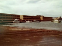
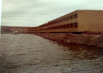
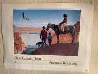
Over 15 years ago, while preparing to launch at Antelope Main Ramp, we found this Norman Rockwell Poster.
There’s probably a lot of excellent documented history about the painting. Maybe some of you even have personal insight. This link provides a good start…

There’s probably a lot of excellent documented history about the painting. Maybe some of you even have personal insight. This link provides a good start…
Norman Rockwell and his Dam Painting
Today’s post is written by Cody White, Archivist at the National Archives at Denver. “That’s a mechanical drawing . . . where’s some human interest?” posed the famous artist as he took in the vista…
text-message.blogs.archives.gov
Attachments
Rainbowbridge
Keeper of San Juan Secrets
"His Dam Painting"...... 
JFRCalifornia
Keeper of San Juan Secrets
Here's the mouth of Moqui Canyon, in October 1923...
