You are using an out of date browser. It may not display this or other websites correctly.
You should upgrade or use an alternative browser.
You should upgrade or use an alternative browser.
Fort Moki
- Thread starter topoman
- Start date
- Status
- Not open for further replies.
capt-capsaicin
Active Member
Did you find the walls of the fort?
No, It would have been in the photo I believe, all gone. Could have been a flash flood from White Canyon that maybe did it in or maybe just time.Did you find the walls of the fort?
THX! J
jayfromtexas
Well-Known Member
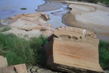
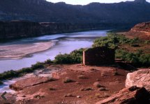
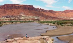
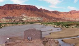
Here's the same point at the mouth of White Canyon. The 2021 image was taken recently by Tom Martin and the second image is a composite/collage I made from Mr. Martin's photograph and an earlier image credited to Hallan Neil Marsh family. These were also posted to an earlier thread about the White Canyon ruins. But sad to say they were most assuredly destroyed by the river.


bob london
Well-Known Member
Here's the same point at the mouth of White Canyon. The 2021 image was taken recently by Tom Martin and the second image is a composite/collage I made from Mr. Martin's photograph and an earlier image credited to Hallan Neil Marsh family. These were also posted to an earlier thread about the White Canyon ruins. But sad to say they were most assuredly destroyed by the river.
View attachment 15374View attachment 15375
You have too much time on your hands, jay. Who's the chubby bird in blue?
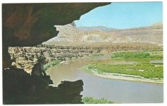
Hi Jay, We've been out to look for Fort Moki Several times starting in 2014 when the the lake was at 3570ish and it was not visible. I have the ruin at 3555 more or less. Having just walked the site last Thursday, the bench is sure washed clean!...Maybe a flash flood from White Canyon??? I wonder it anyone has an old slide of the Petroglyph panel that is still visible. Tom McCourt says that there were many inscriptions and I have an old Photo of Powell's from 1872. FUN stuff! THX! JohnHere's the same point at the mouth of White Canyon. The 2021 image was taken recently by Tom Martin and the second image is a composite/collage I made from Mr. Martin's photograph and an earlier image credited to Hallan Neil Marsh family. These were also posted to an earlier thread about the White Canyon ruins. But sad to say they were most assuredly destroyed by the river.
View attachment 15374View attachment 15375
jayfromtexas
Well-Known Member
Hi John,Hi Jay, We've been out to look for Fort Moki Several times starting in 2014 when the the lake was at 3570ish and it was not visible. I have the ruin at 3555 more or less. Having just walked the site last Thursday, the bench is sure washed clean!...Maybe a flash flood from White Canyon??? I wonder it anyone has an old slide of the Petroglyph panel that is still visible. Tom McCourt says that there were many inscriptions and I have an old Photo of Powell's from 1872. FUN stuff! THX! John
You're welcome! Yes, I'm afraid the bench that Fort Moki was perched on has been washed quite clean. If you look at Google Earth images over the last several years it appears that the river channel was flowing over the site a couple years ago and scoured it clear off. I think someone mentioned on here somewhere not too long ago that ruins sat at an elevation of approximately 3570.
Jay
jayfromtexas
Well-Known Member
Bob,You have too much time on your hands, jay. Who's the chubby bird in blue?
Haha! I don't know who the bird in blue is, I would hazard a guess she is an acquaintance of Mr. Martin.
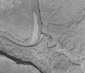
I Have a 1952 Aerial Photo that shows the area very well, including the old town. I'll try to post it.Hi John,
You're welcome! Yes, I'm afraid the bench that Fort Moki was perched on has been washed quite clean. If you look at Google Earth images over the last several years it appears that the river channel was flowing over the site a couple years ago and scoured it clear off. I think someone mentioned on here somewhere not too long ago that ruins sat at an elevation of approximately 3570.
Jay
jayfromtexas
Well-Known Member
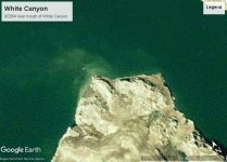
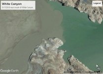
Would love to see those historical photos! This is from Google Earth in 2004 (unfortunately they don't have anything from March 2005) that shows a barely submerged white rectangle that may be the White Canyon ruins. The second image shows the river blasting through the same area around 2016I Have a 1952 Aerial Photo that shows the area very well, including the old town. I'll try to post it.
.
bob london
Well-Known Member
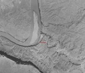
Here Goes...1952 before LP! Hope you can zoom in as there's a lot of detail.View attachment 15409
Excellent find, topoman ! Thanks for sharing. Yup, zoomed right in to wallow in the detail. Love it !
Chaffin must have been an extraordinarily dogged fellow. That low-water causeway for his ferry must have been regularly flushed away during times of high flow. Every year no doubt, once the spring runoff had passed, he must have been bulldozing more material into the river to keep the crossing operational.
Let us not forget that he also instigated, and ultimately bulldozed, the road down North Wash to connect Hite with Hanksville and later did the same up Farley Canyon and beyond to reach Blanding, thus creating U-95. Obviously, the ferry was to be the catch point to monetise his efforts.
Upon learning that the Hite Ferry site would be flooded by the the rising waters behind Glen Canyon dam, he sold the business on and set about recompense from the powers that be. I believe, eventually, he was awarded $8000 for the loss of his land, property and business. A great Utahn pioneer was told his 30, and some, years' efforts to open up that area to Joe Public was worth, a miserly, eight grand.
It's sad that this little community, 170 miles from the dam, was sacrificed for the 'greater good' and it's hard to fathom that this area would eventually end up under 260 feet of water. As of 4th October 2021, and without the 150 feet-deep sedimentary deposits, this place would still be 100 feet under water.
But it isn't. This is a dead zone. I doubt the reservoir will ever again trouble the mouth of Farley Canyon. The concrete ramp at Hite marina is a half mile from the river (does anyone know when that was poured?).
Oh dear, I've reverted to my gloom and doom mode again
Here's topo's picture with Fort Moki arrowed. Thanks again.
JFRCalifornia
Keeper of San Juan Secrets
Rainbowbridge
Escalante-Class Member
Now Bob, She's the Blue Bird of Happiness.....You have too much time on your hands, jay. Who's the chubby bird in blue?
Tiff Mapel
Escalante-Class Member
Wow, what a difference! I'm so bummed I never got to see Fort Moki in person. I rarely ever get to that end of the lake. Next, I'd like to see Wasp House in Lake Canyon. It's a similar square-shaped ruin that's tucked up into an alcove on a wall. Not sure the water elevation in which it would be visible? Anyone know?Here's the same point at the mouth of White Canyon. The 2021 image was taken recently by Tom Martin and the second image is a composite/collage I made from Mr. Martin's photograph and an earlier image credited to Hallan Neil Marsh family. These were also posted to an earlier thread about the White Canyon ruins. But sad to say they were most assuredly destroyed by the river.
View attachment 15374View attachment 15375
Tiff
JFRCalifornia
Keeper of San Juan Secrets
Tiff--Wow, what a difference! I'm so bummed I never got to see Fort Moki in person. I rarely ever get to that end of the lake. Next, I'd like to see Wasp House in Lake Canyon. It's a similar square-shaped ruin that's tucked up into an alcove on a wall. Not sure the water elevation in which it would be visible? Anyone know?
Tiff
Not entirely sure the elevation of Wasp House, but these two photos taken in June 1964 provide a clue. You can see the rising lake in the foreground on one of them, maybe 25-30 feet below the base of the ruin. The only problem in trying to estimate the lake level is that the lake rose quickly that month--it was at 3437 on June 1, but all the way up to 3472 on June 30! And I don't know which day the photos were taken. But assuming the midpoint of about 3455, then I'd guess Wasp House is at about 3480-3485. But could be as high as 3500, or as low as 3470. Either way, it's still underwater...and possibly under silt...
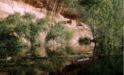
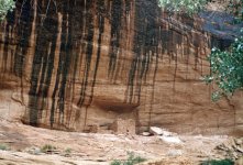
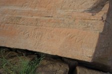
Hi Fort Moki aficionadas, Now that we found the exact location of the now extinct "Ft Moki" we need to find where this is! It was located "near the ruin". Last Thursday we located the petroglyph panel behind the ruin with many of the Glyphs still visible after almost 60 years underwater! Tom McCourt says there are many pioneer names there but we couldn't make them out. Anybody out there got an old slide? WAY Fun stuff!!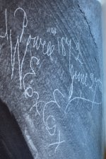

Tiff Mapel
Escalante-Class Member
I don't know if this has been mentioned yet, but a good read is White Canyon by Tom McCourt. In fact, Tom has a number of really great books on the desert southwest. Cass Hite - King of the Colorado is another good one.
Tiff
Tiff
bob london
Well-Known Member
- Status
- Not open for further replies.

